Here’s a look at our Thursday late evening planner for the DFW Metroplex.

Here’s a look at our Thursday late evening planner for the DFW Metroplex.
Here is a look at Actual Highs from around North Texas today.

Actual Highs from around the Dallas – Fort Worth Metroplex today.

Today’s complete DFW Almanac.

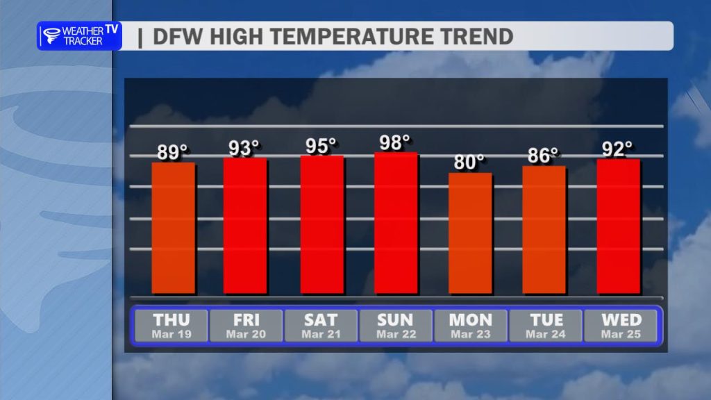
Here’s a look at the Thursday evening planner for the DFW Metroplex.

A warm and quiet night is ahead for the Metroplex. Skies will stay clear with light south winds, and temperatures will settle comfortably into the upper 50s by early Friday morning.
Friday brings even more heat. Expect full sunshine with afternoon highs climbing into the lower 90s across Dallas–Fort Worth. Winds will stay light out of the south to southwest, adding to that early taste of summer. Friday night remains clear and mild, with lows in the lower 60s.
The weekend turns downright hot for March. Highs surge into the mid 90s Saturday and upper 90s Sunday under wall-to-wall sunshine. If you have outdoor plans, be prepared for unseasonably warm conditions and take extra breaks in the shade.
A slight cooldown arrives Monday with highs backing into the mid 80s, followed by a steady warming trend into the upper 80s and lower 90s through midweek. Rain chances remain near zero, and the dry stretch continues.
Plan for summer-like heat this weekend, especially Sunday afternoon.
Stay with William Cole & Weather Tracker TV.
Let’s stay safe together.
Tonight

Tonight – Precipitation

Tomorrow

Tomorrow – Precipitation

Here’s a look at our Thursday evening commute in the DFW Metroplex.


Here’s a look at Live Temperatures across North Texas, MesoScan Radar and the Updated Forecast Map.
DFW TODAY Sunny, warmer with highs in the upper 80s. Southwest winds 5 to 10 mph. -William

Good Thursday morning, North Texas!
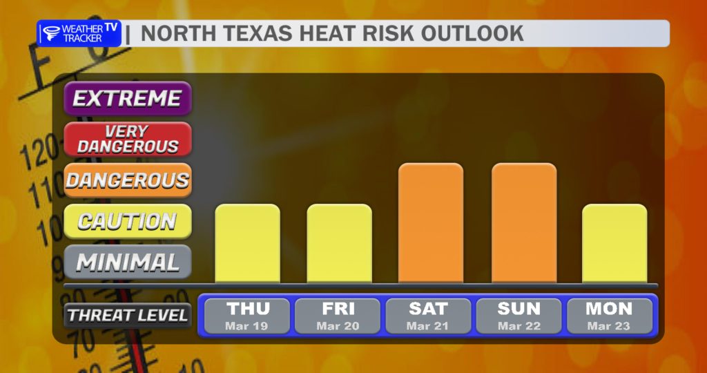
We’re heading into a hot stretch of weather across the region as a strong ridge of high pressure builds overhead. This will set the stage for a mini heat wave through the upcoming weekend, with temperatures climbing higher each day.
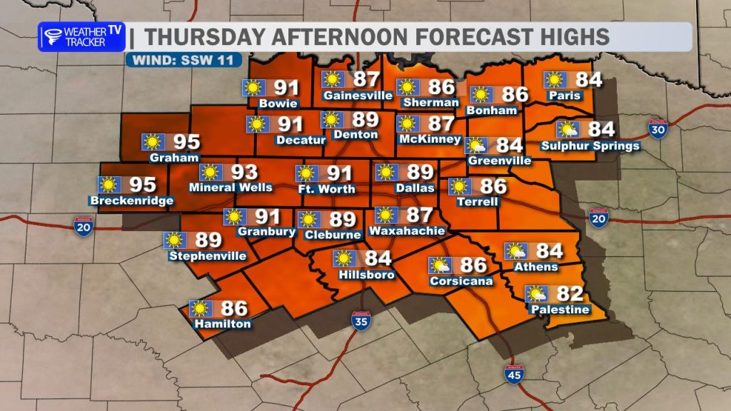
That warming trend begins today. Afternoon highs will push close to 90 degrees across the Metroplex, with a few mid-90s possible in our western counties. Plenty of sunshine and a developing southerly breeze will help fuel the heat.
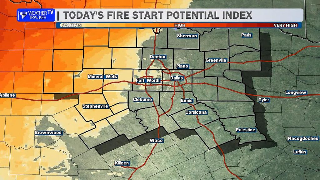
The forecast remains dry through the weekend, but that brings an increased concern for fire danger. Hot temperatures, dry vegetation, and gusty south winds will create elevated to potentially critical fire weather conditions—especially west of Interstate 35. It’s important to avoid any outdoor burning or activities that could create sparks. Fires that develop in these conditions can spread quickly.
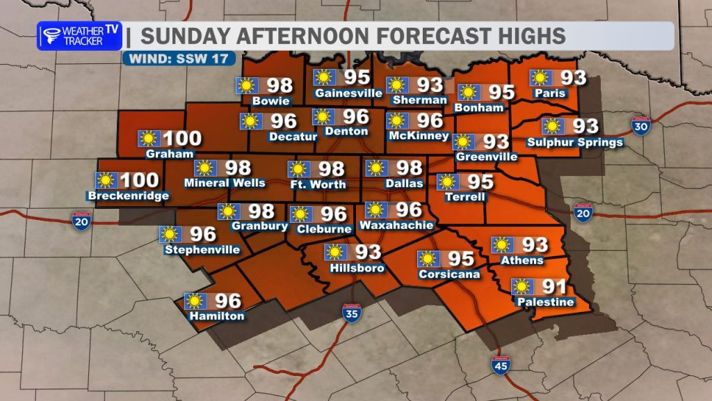
As we head into the weekend, the heat intensifies. Saturday will be hot, but Sunday looks to be the peak of this stretch. High temperatures may approach or even reach 100 degrees in parts of western North Texas and the Big Country, with mid to upper 90s elsewhere. If you have outdoor plans, be sure to stay hydrated and take breaks from the heat.
A cold front is expected to arrive late Sunday, bringing at least some relief. While rain chances look limited at this time, the front will help knock temperatures down heading into early next week.
By Monday, highs fall back into the 80s with slightly cooler mornings—offering a noticeable break from the weekend heat.
Here is a look at Actual Lows from around North Texas this morning.

Actual Lows from around the Dallas – Fort Worth Metroplex this morning.

Here’s a look at our Thursday planner for the DFW Metroplex.

After a cool start earlier this week, North Texas is heating up in a hurry.
Today will be sunny and much warmer across the Dallas–Fort Worth Metroplex. Afternoon highs climb into the upper 80s with a light southwest breeze around 5 to 10 mph. It’ll feel more like late May than mid-March by the time you head home.
Tonight stays clear and mild, with lows dipping into the upper 50s. Winds remain light out of the south.
Tomorrow turns even hotter. Expect full sunshine again with highs reaching the lower 90s area-wide. Southwest winds stay light, but the warming trend continues.
Looking ahead, we only get hotter this weekend. Mid to upper 90s are likely Saturday and Sunday under mainly sunny skies. A cold front arrives Monday, knocking highs back into the upper 70s to low 80s with cooler mornings in the 50s early next week.
It’s an early taste of summer, so stay hydrated and take it easy during the afternoon heat.
Stay with William Cole & Weather Tracker TV.
Let’s stay safe together.
Today
Today – Precipitation
Tonight

Tomorrow
