Mini Heat Wave Grips North Texas This Weekend

Good Saturday morning, North Texas!

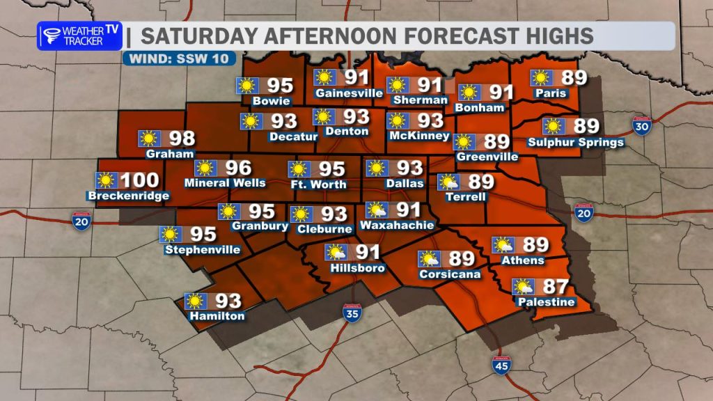
We’re kicking off the weekend with a taste of summer as a mini heat wave settles across the region. Expect a hot afternoon with high temperatures climbing well into the 90s for most of North Texas. Out west, especially across the Big Country, a few spots could approach the 100-degree mark. Skies will remain sunny with a steady south breeze adding to that early-season summer feel.

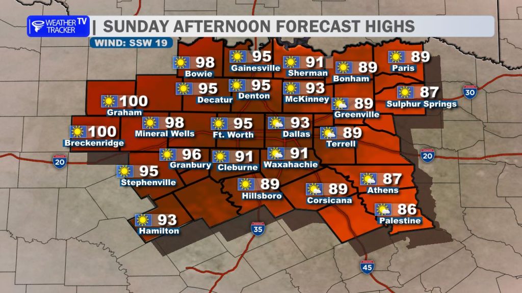
The heat only intensifies heading into Sunday, which looks to be the hottest day of the weekend. Highs will once again soar into the 90s area-wide, with upper 90s to near 100 degrees possible in our western counties. With plenty of sunshine and a continued south wind, a record high temperature at DFW is certainly within reach.

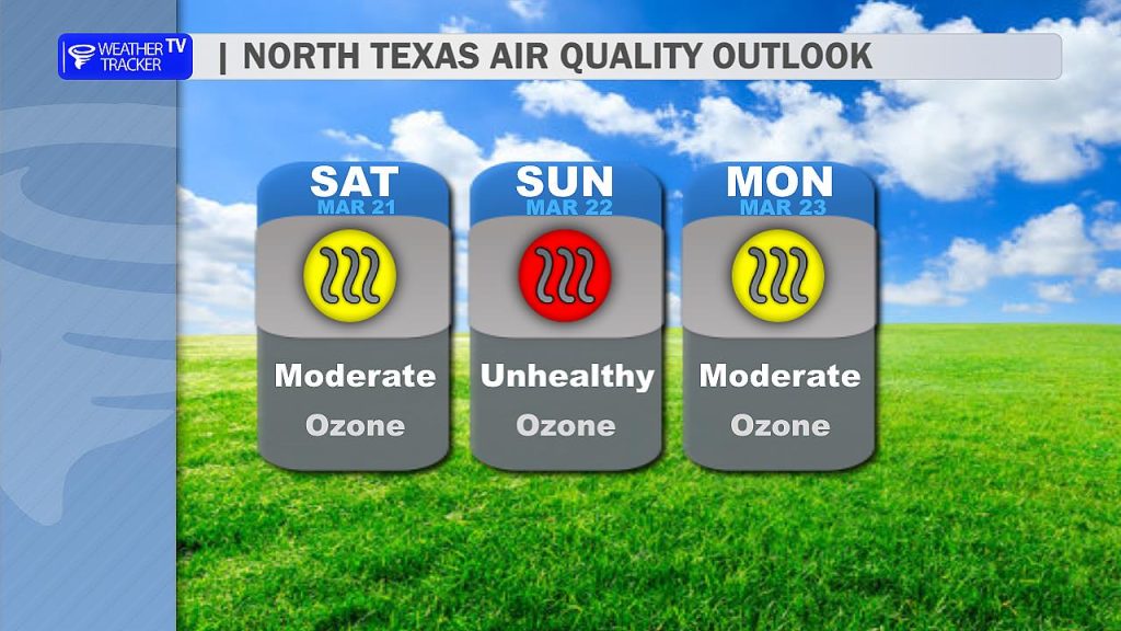
In addition to the heat, air quality could become an issue on Sunday. Ozone levels may build, especially during the afternoon hours. If you’re sensitive to poor air quality, it’s a good idea to limit prolonged outdoor activity and take breaks indoors when possible.

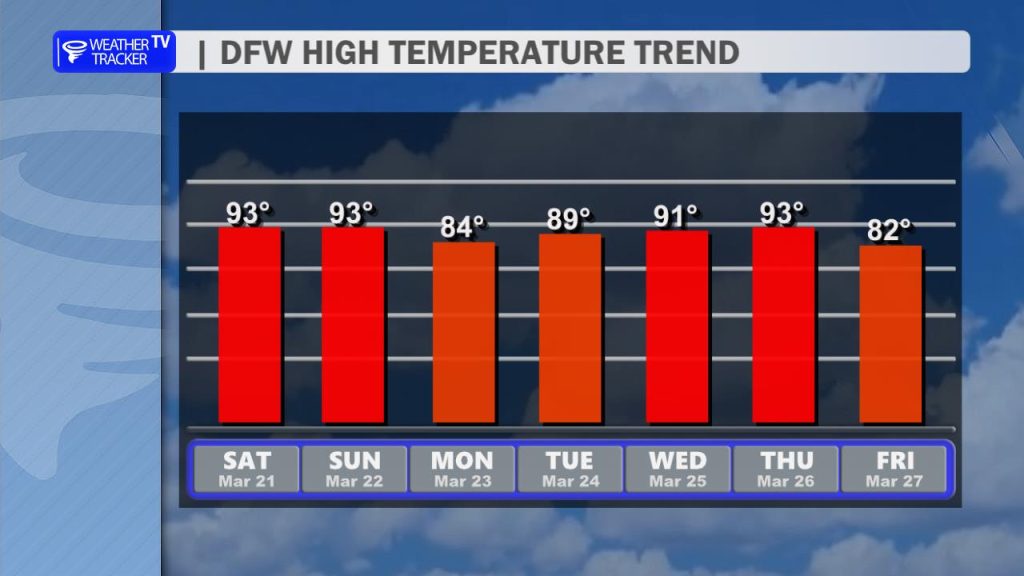
Relief does arrive, though it’s brief. A cold front will move through late Sunday, knocking temperatures back into the 80s on Monday. While that will feel noticeably cooler, it won’t last long. Temperatures are expected to rebound into the 90s as we head into the middle of next week.

Rain chances remain out of the picture, so the dry and hot pattern continues for now.

Today’s DFW Forecast

It’s a warm and quiet stretch of weather across North Texas.

Today will be sunny and unseasonably hot for late March. Highs across the Dallas–Fort Worth Metroplex will climb into the lower 90s this afternoon with a light south wind around 5 to 10 mph. If you’re spending time outdoors, it’s going to feel more like early summer than early spring.

Tonight stays clear and mild with lows only dipping into the mid 60s. South winds will continue around 5 to 10 mph.

Sunday brings more sunshine and another hot afternoon. Highs will again reach the lower 90s, with south winds increasing to 10 to 15 mph and occasionally higher in the afternoon. It’ll be breezy at times, especially west of DFW.

Looking ahead, a wind shift Monday brings slightly cooler air with highs easing back into the low to mid 80s before temperatures rebound later next week.

Stay with William Cole & Weather Tracker TV.
Let’s stay safe together.

Today

North Texas Today Forecast

Today – Precipitation

North Texas Today Precipitation Forecast

Tonight

North Texas Tonight Forecast

Tomorrow

North Texas Tomorrow Forecast

Tonight’s DFW Forecast

A warm and quiet night is ahead across the Metroplex. Skies stay clear with south winds easing back to 5 to 10 mph. Temperatures will fall into the lower 60s by morning, making for a mild start to Saturday.

The heat continues to build into the weekend. Saturday will be sunny and hotter, with afternoon highs climbing into the mid 90s around Dallas and Fort Worth. Winds remain out of the south at 5 to 10 mph. Sunday looks even warmer, with many spots reaching the mid to upper 90s under full sunshine. A steady south breeze at 10 to 15 mph will add to the early-season summer feel.

A weak front arrives Monday, knocking temperatures back into the mid 80s with mostly sunny skies. It’s not a major cooldown, but you’ll notice the difference. After that, temperatures gradually rebound into the upper 80s and low 90s through mid to late week with plenty of sun.

Stay hydrated this weekend and take breaks if you’re spending extended time outdoors during the afternoon heat.

Stay with William Cole & Weather Tracker TV.
Let’s stay safe together.

Tonight

North Texas Today Forecast

Tonight – Precipitation

North Texas Today Precipitation Forecast

Tomorrow

North Texas Tonight Forecast

Tomorrow – Precipitation

North Texas Tomorrow Forecast