Rainy Start to Saturday Across North Texas; Strong Storms Possible South of DFW

Good Saturday morning, North Texas!

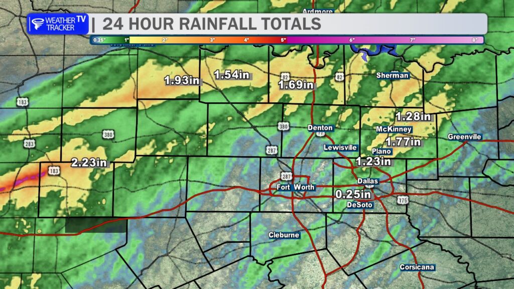
It’s been a wet start to the day across the region with multiple rounds of rain, including periods of heavy rainfall overnight and early this morning. Another round of rain is continuing to push southeast across North Texas and will likely linger through the late morning and into parts of the afternoon.

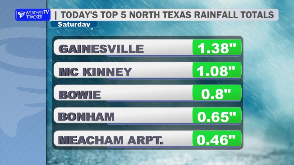
Rainfall totals across the Dallas–Fort Worth Metroplex have been locally excessive at times, prompting several flash flood warnings overnight. Some roads may still have standing water this morning, so use caution if you’re heading out. Remember the rule: Turn Around, Don’t Drown. Just a few inches of moving water can sweep a vehicle away.

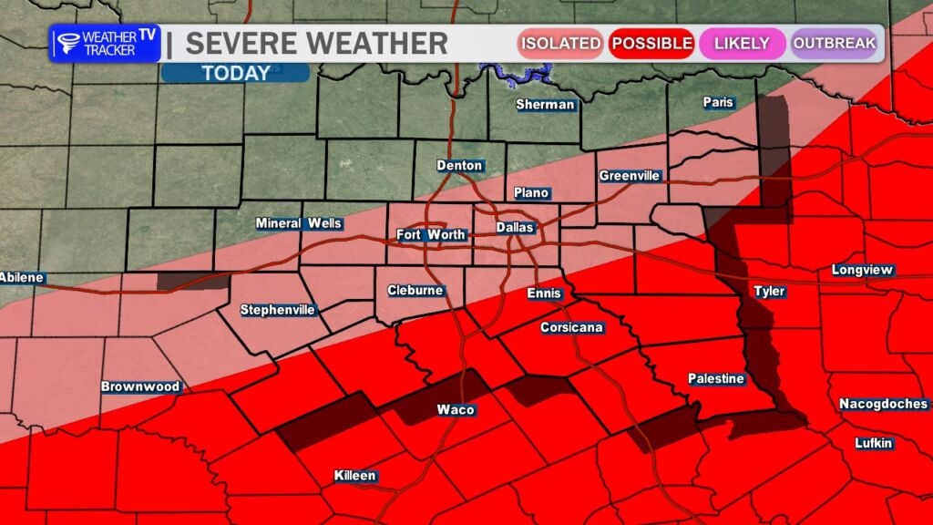
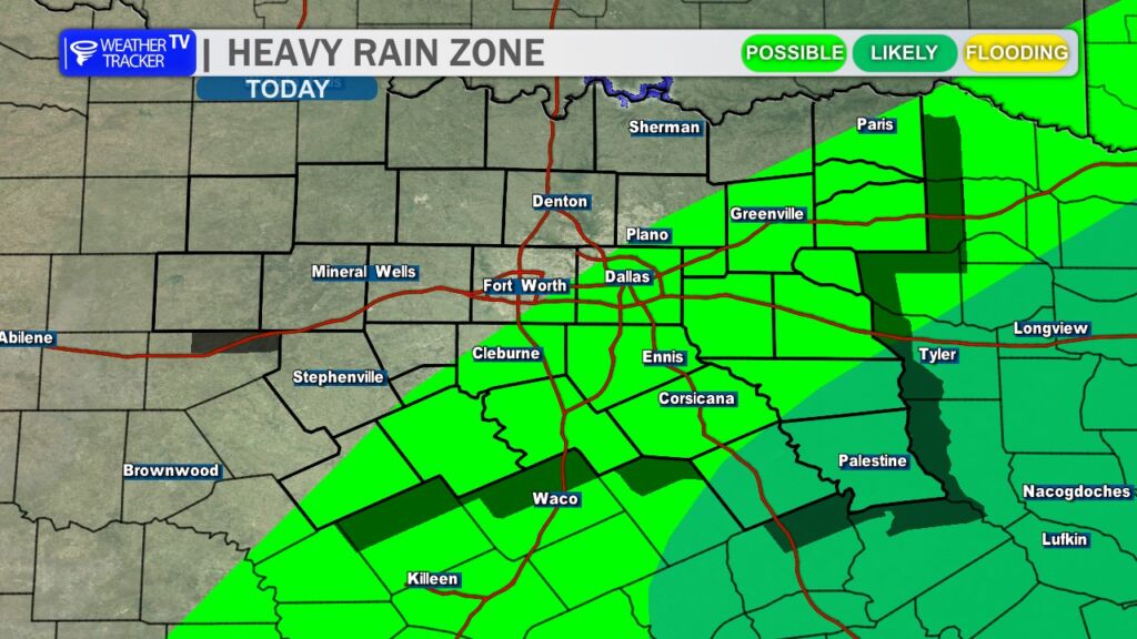
The wet weather is being driven by a cold front moving through the region. As the front continues to slide southeast through North Texas this afternoon, the focus for additional thunderstorm development will gradually shift south of the Dallas–Fort Worth area.

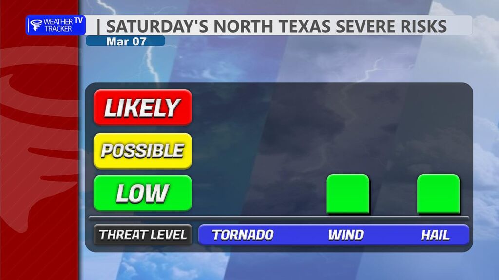
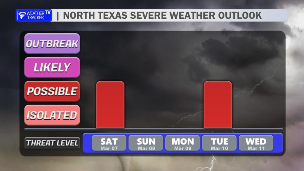
While widespread severe weather is not expected, a few storms could become strong to severe, mainly south of the Metroplex later today. The primary threats would be hail up to half-dollar size and wind gusts approaching 60 mph. Lightning and brief heavy rainfall will also accompany any thunderstorms that develop.

Behind the front, conditions will begin to improve tonight.

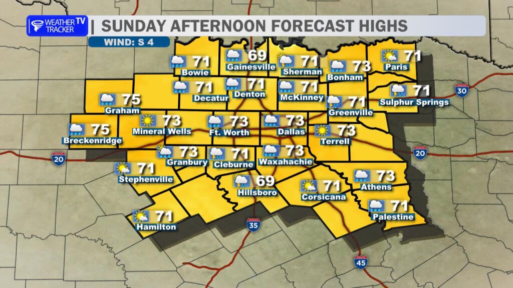
Sunday looks much quieter. Skies will clear out and temperatures will turn a bit cooler, with afternoon highs generally in the 70s across North Texas. It should be a pleasant end to the weekend.

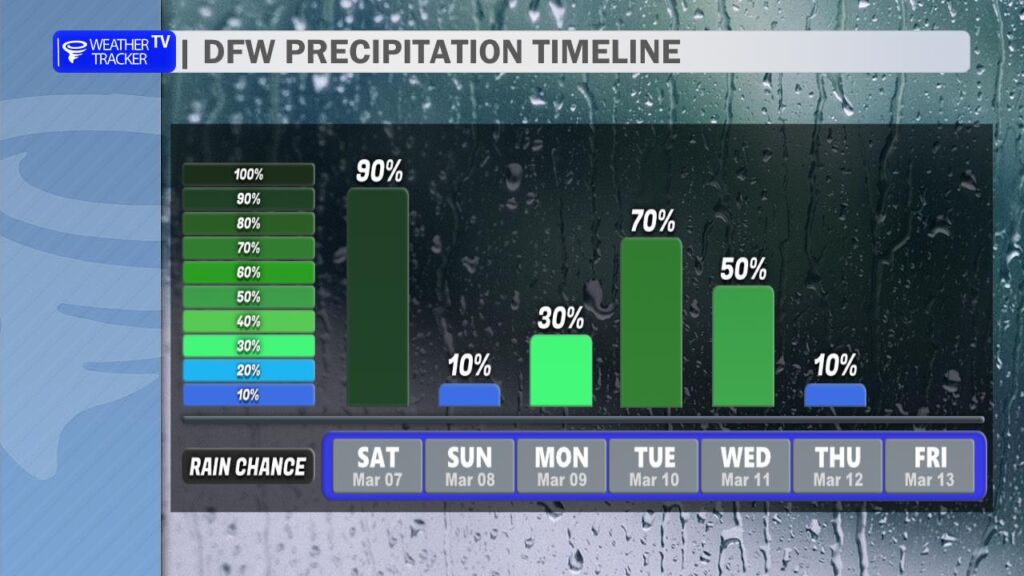
The break in the rain will be short-lived, though. Another storm system arrives early next week, bringing renewed chances for showers and thunderstorms Monday into Tuesday. It’s still early, but some of those storms could again become strong to severe depending on how the atmosphere evolves.

We’ll continue to fine-tune that forecast over the next couple of days. -William

9:45 AM Radar Update

A strong thunderstorm is moving across parts of North Texas this morning. Gusty winds, small hail, heavy rain, and frequent lightning are all possible as it moves through.

Live Local Radar

**Timing:**
– Ongoing as of 9:44 AM
– Expected to impact areas through 10:15 AM
– Near De Leon and Proctor Lake around 9:55 AM

**What to Expect:**
– Winds in excess of 40 mph
– Hail up to half an inch in diameter
– Torrential rainfall
– Frequent cloud-to-ground lightning

**Impacted Areas:**
– Southwestern Erath County
– Southeastern Eastland County
– Central Comanche County
– De Leon
– Proctor Lake
– Comyn
– Downing
– Rucker
– Proctor
– Van Dyke
– Hasse
– Beattie
– Sipe Springs
– Sidney
– Desdemona

**Potential Impacts:**
– Tree limbs could be knocked down
– Unsecured outdoor objects may be blown around
– Minor damage to outdoor items is possible
– Localized flooding may occur
– Lightning strikes can happen up to 10 miles away from the storm

**What to Do Now:**
– If you are outdoors, seek shelter inside a sturdy building
– Do not drive through flooded roadways
– Move indoors or into a vehicle if lightning is nearby

Stay with William Cole and Weather Tracker TV.
Let’s stay safe together.

NOW UPDATE | Saturday 9:45 AM Erath County

Texas Weather Tracker TV Alert

From William Cole: A strong T-Storm will impact portions of southwestern Erath, southeastern Eastland and central Comanche Counties through 1015 AM

At 944 AM , Live Radar was tracking a strong T-Storm 7 miles northwest of Comanche, moving northeast at 40 mph.

Winds In Excess Of 40 Mph And Half Inch Hail. Gusty Winds Could Knock Down Tree Limbs And Blow Around Unsecured Objects. Minor Damage To Outdoor Objects Is Possible.

Stay with William Cole and Weather Tracker TV Dallas – Fort Worth for continuing coverage, online, on our app and on TV. Let’s stay safe together.

Your Support Helps

9:42 AM Flash Flood Warning

Flash flooding is happening or about to begin in parts of North Texas as heavy rain continues this morning. A Flash Flood Warning is in effect for eastern Kaufman County, Rains County, and western Van Zandt County until noon.

Live Local Radar

**Timing:**
– In effect until noon
– At 9:42 AM, radar showed heavy thunderstorms producing up to 1.5 inches of rain
– An additional 1 to 2 inches of rainfall is expected

**What to Expect:**
– Flash flooding caused by thunderstorms
– Flooding of small creeks and streams
– Flooding in urban areas, highways, streets, and underpasses
– Water covering low-lying and poor drainage areas

**Potential Impacts:**
– Hazardous travel conditions
– Rapidly changing water levels in flood-prone locations

**What to Do Now:**
– Turn around, don’t drown when encountering flooded roads
– Never drive through water covering a roadway
– Stay alert and be aware of your surroundings

Areas impacted include Kaufman, Canton, Wills Point, Grand Saline, Mabank, Seven Points, Edgewood, Emory, Kemp, Fruitvale, Grays Prairie, Cottonwood, New Terrell City Lake, Lake Tawakoni, Cedar Creek Reservoir, Lake Fork Reservoir, Myrtle Springs, Elmo, Scurry, and Oak Grove.

Stay with William Cole and Weather Tracker TV.
Let’s stay safe together.

ALERT 9:42 AM | Flash Flood Warning Kaufman, Rains & Van Zandt Counties until 12:00 PM Saturday

Texas Weather Tracker TV Alert

From William Cole: A Flash Flood Warning has been issued in the Weather Tracker TV DFW coverage area for Kaufman, Rains & Van Zandt Counties in North Texas until 12:00 PM.

At 942 AM , Live Radar indicated T-Storms producing heavy rain across the warned area. Up to 1.5 inches of rain have fallen. Additional rainfall amounts of 1 to 2 inches are forecast. Flash flooding is ongoing or expected to begin shortly.

Remember if you see water across a roadway do not drive through it. Turn Around Don’t Drown.

Stay with William Cole and Weather Tracker TV Dallas – Fort Worth for continuing coverage, online, on our app and on TV. Let’s stay safe together.

Your Support Helps

8:36 AM T-Storm Warning

A Severe Thunderstorm Warning is in effect for parts of North Texas through 9:15 AM. A strong storm is moving northeast and could produce quarter-size hail and gusty winds.

Live Local Radar

**Timing:**
– Until 9:15 AM
– At 8:35 AM, the storm was 7 miles northeast of Rising Star, or 16 miles south of Eastland
– Moving northeast at 35 mph
– Near Gorman around 8:50 AM
– Near Lake Leon around 8:55 AM

**What to Expect:**
– Quarter-size hail
– Wind gusts up to 40 mph
– Heavy rainfall
– Includes Interstate 20 between mile markers 341 and 353

**Potential Impacts:**
– Damage to vehicles is possible
– Flash flooding may develop
– Hazardous travel, especially on flooded roadways

**What to Do Now:**
– Get inside a sturdy structure
– Stay away from windows
– Do not drive through flooded roadways

Stay with William Cole and Weather Tracker TV.
Let’s stay safe together.

8:36 AM | T-Storm Warning Erath County until 9:15 AM Saturday

Texas Weather Tracker TV Alert

From William Cole: A T-Storm Warning has been issued in the Weather Tracker TV DFW coverage area for Erath County in North Texas until 9:15 AM.

At 835 AM , a severe T-Storm was located 7 miles northeast of Rising Star, or 16 miles south of Eastland, moving northeast at 35 mph.

Hometowns Impacted: Gorman Around 850 Am . Lake Leon Around 855 Am .

Primary Threats: Quarter Size Hail And Wind Gusts Up To 40 Mph.

Stay with William Cole and Weather Tracker TV Dallas – Fort Worth for continuing coverage, online, on our app and on TV. Let’s stay safe together.

Your Support Helps

8:13 AM Flash Flood Warning

A Flash Flood Warning is in effect for parts of North Texas this morning. Heavy rain is causing flash flooding in Dallas and Rockwall counties.

Live Local Radar

**Timing:**
– In effect until 11:00 AM
– At 8:12 AM, radar showed thunderstorms producing heavy rain across the area
– Up to 1 inch of rain has already fallen
– An additional 1 inch of rain is possible
– Flash flooding is ongoing or expected to begin shortly

**What to Expect:**
– Flash flooding caused by thunderstorms
– Flooding of small creeks and streams
– Flooding in urban areas, highways, streets, and underpasses
– Water covering poor drainage and low-lying areas

**Potential Impacts:**
– Dangerous driving conditions
– Rapid water rise in flood-prone locations

– Areas impacted include Dallas, Garland, Irving, Grand Prairie, Mesquite, Rowlett, Desoto, Cedar Hill, Wylie, Duncanville, Rockwall, Lancaster, Balch Springs, Sachse, Seagoville, Glenn Heights, Highland Park, Hutchins, Cockrell Hill, and Royse City.

**What to Do Now:**
– Turn around, don’t drown when encountering flooded roads
– Most flood deaths occur in vehicles
– Do not drive on flooded roads
– Stay aware of your surroundings

Stay with William Cole and Weather Tracker TV.
Let’s stay safe together.

ALERT 8:12 AM | Flash Flood Warning Dallas & Rockwall Counties until 11:00 AM Saturday

Texas Weather Tracker TV Alert

From William Cole: A Flash Flood Warning has been issued in the Weather Tracker TV DFW coverage area for Dallas & Rockwall Counties in North Texas until 11:00 AM.

At 812 AM , Live Radar indicated T-Storms producing heavy rain across the warned area. Up to 1 inch of rain has fallen. Additional rainfall amounts up to 1 inch are forecast. Flash flooding is ongoing or expected to begin shortly.

Remember if you see water across a roadway do not drive through it. Turn Around Don’t Drown.

Stay with William Cole and Weather Tracker TV Dallas – Fort Worth for continuing coverage, online, on our app and on TV. Let’s stay safe together.

Your Support Helps