Here’s a look at Live Temperatures across North Texas, MesoScan Radar and the Updated Forecast Map.
DFW TODAY Cloudy with a chance of showers. A slight chance of T-Storms this morning, then a chance of T-Storms this afternoon. Highs around 80. South winds 10 to 15 mph. Chance of rain 40 percent. -William
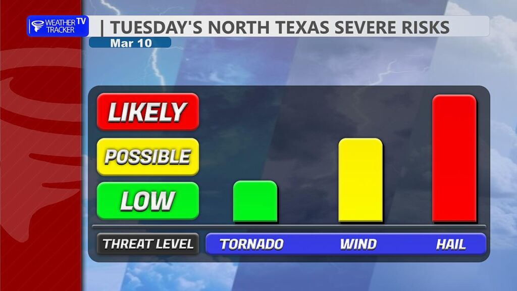
The risk of severe weather returns to the region later this afternoon and continues through this evening and overnight. All modes of severe weather will be possible, including large hail, damaging wind gusts, and a few tornadoes.
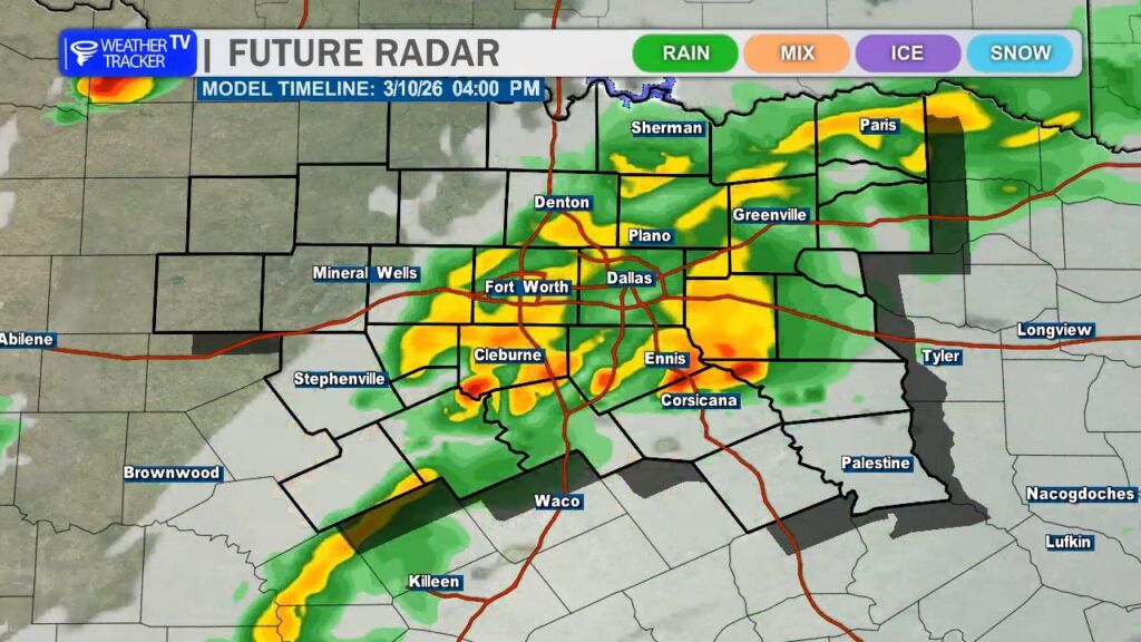
For much of the afternoon, we may see scattered showers across the area, but most of that activity should remain fairly light. The first storms to watch closely could develop around 4 PM near or just south of the Dallas–Fort Worth Metroplex. While this early development is not expected to be the main round of storms, any storm that does form in this environment could quickly become severe, so it will be something to monitor closely during the late afternoon hours.
The main round of storms is expected to develop along the dryline in West Texas and the Big Country late this afternoon. Those storms will gradually organize and push east toward North Texas through the evening.
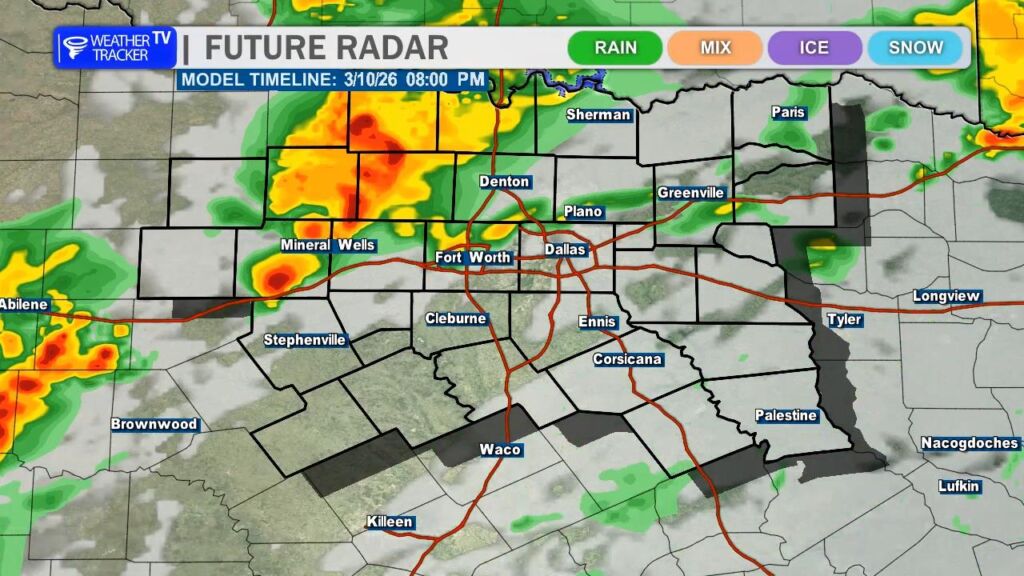
As this activity moves into our western counties early this evening, storms may initially be somewhat discrete or in broken line segments, which could allow a few supercells to develop. During this phase, the primary threats will be very large hail and the potential for a tornado or two. Some hailstones could be quite large, potentially up to baseball size, especially with the first storms entering western North Texas.
As the storms continue eastward through the evening, they will likely merge into a more organized squall line. When this happens, the severe threat will shift somewhat. Hail sizes should gradually decrease, though golf ball–sized hail will still be possible. At the same time, the damaging wind threat will increase, with gusts potentially reaching 60 to 70 mph.
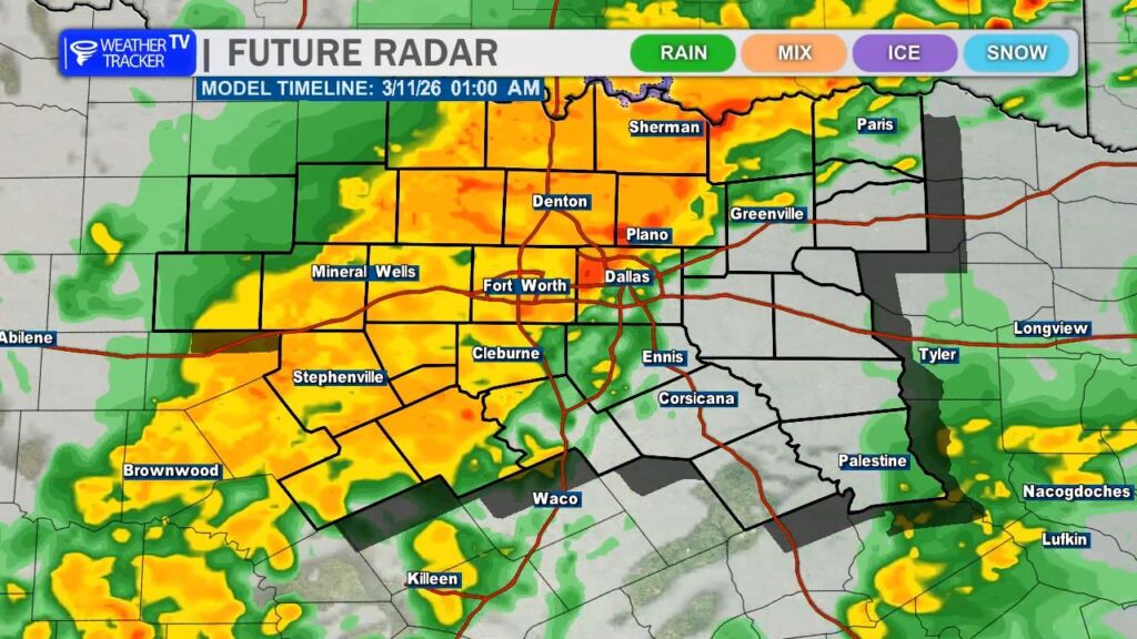
Even within the line of storms, a brief spin-up tornado cannot be ruled out, especially along the leading edge of the squall line where quick QLCS-type tornadoes can sometimes develop.
The line of storms should move across much of North Texas late this evening into the overnight hours, gradually weakening as it pushes east of the I-35 corridor.
Make sure you have a way to receive weather warnings tonight, especially since some of the strongest storms could occur after sunset when people are settling in for the evening. -William
Clouds stick around today with scattered showers and a few thunderstorms developing, especially by this afternoon. It’ll feel warm and a bit humid with south winds at 10 to 20 mph and highs near 80 degrees across Dallas–Fort Worth. Rain coverage won’t be continuous, but keep the umbrella handy as spotty downpours move through.
Tonight is when rain becomes more widespread. Showers and embedded thunderstorms are likely, with rain chances around 90 percent. Temperatures will hold in the lower 60s with a steady south breeze. A few heavier downpours are possible overnight, which could lead to brief ponding on roads by early Wednesday.
Wednesday starts unsettled with lingering showers and a few storms, then gradual clearing is expected during the afternoon as a cold front pushes through. Highs will reach the mid to upper 70s before cooler, drier air arrives. Winds turn north and pick up, with gusts up to 30 mph by late day. Wednesday night drops into the 40s under clearing skies.
Wet roads and gusty winds could impact the Wednesday commute.
Stay with William Cole & Weather Tracker TV.
Let’s stay safe together.
A warm and breezy evening is ahead across the Metroplex. Skies will turn mostly cloudy overnight with temperatures holding mild, only falling into the upper 60s. South winds will stay light to occasionally moderate.
Tuesday brings increasing rain chances as a storm system approaches. Expect mostly cloudy skies with scattered showers and thunderstorms developing, especially during the afternoon. Highs will top out near 80 degrees. While not everyone will see rain during the day, coverage increases significantly Tuesday night. Showers and thunderstorms become widespread after sunset with rain likely continuing through much of the night. A few storms could produce brief heavy downpours.
Wednesday stays unsettled with additional showers and a few storms early, then gradual clearing late in the day as a cold front sweeps through. Winds will shift to the north and become gusty, and temperatures will fall from the 70s into the 60s by afternoon. Much cooler air settles in Wednesday night with lows dropping into the 40s.
Sunshine returns Thursday, followed by a warming trend into the 80s this weekend.
Plan for wet roads Tuesday night and early Wednesday, along with a noticeable midweek cooldown.
Stay with William Cole & Weather Tracker TV.
Let’s stay safe together.