Severe Weather Update 6:56 PM Stephens County

Texas Weather Tracker TV Alert

From William Cole: A T-Storm Warning continues for for Stephens County in North Texas until 7:15 PM.

At 655 PM , a severe T-Storm was located near Necessity, or near Breckenridge, moving northeast at 30 mph.

Primary Threats: Two Inch Hail And 60 Mph Wind Gusts.

Stay with William Cole and Weather Tracker TV Dallas – Fort Worth for continuing coverage, online, on our app and on TV. Let’s stay safe together.

Your Support Helps

Severe Weather Update 6:34 PM Stephens County

Texas Weather Tracker TV Alert

From William Cole: A T-Storm Warning continues for for Stephens County in North Texas until 7:15 PM.

At 633 PM , a severe T-Storm was located 7 miles west of Lake Daniel, or 10 miles southwest of Breckenridge, moving northeast at 30 mph.

Primary Threats: Ping Pong Ball Size Hail And 60 Mph Wind Gusts.

Stay with William Cole and Weather Tracker TV Dallas – Fort Worth for continuing coverage, online, on our app and on TV. Let’s stay safe together.

Your Support Helps

6:08 PM T-Storm Warning

A Severe Thunderstorm Warning is in effect for parts of North Texas until 7:15 PM. A strong storm near Moran is moving northeast and could bring damaging winds and large hail.

Live Local Radar

**Timing:**
– Until 7:15 PM
– At 6:07 PM, the storm was near Moran, about 13 miles northwest of Cisco
– Moving northeast at 30 mph
– Near Lake Daniel around 6:30 PM
– Also impacting Eolian and Harpersville

**What to Expect:**
– Wind gusts up to 60 mph
– Hail up to 1.25 inches (half-dollar size)

**Potential Impacts:**
– Hail damage to vehicles
– Wind damage to roofs, siding, and trees

**What to Do Now:**
– Get inside a sturdy structure
– Stay away from windows
– A Tornado Watch remains in effect until 11:00 PM

Stay with William Cole and Weather Tracker TV.
Let’s stay safe together.

6:08 PM T-Storm Warning

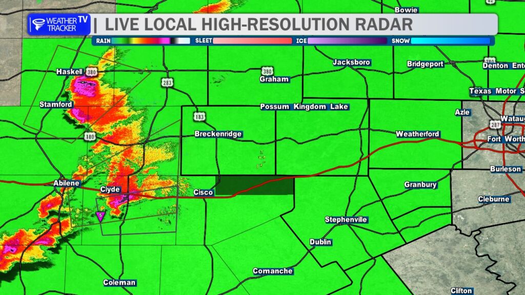
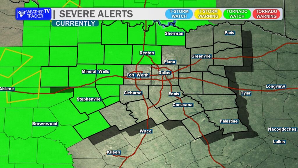
A Severe Thunderstorm Warning is in effect for parts of North Texas until 7:15 PM. A strong storm is moving northeast at 30 mph and could bring damaging wind and large hail.

Live Local Radar

**Timing:**
– Until 7:15 PM
– At 6:07 PM, the storm was near Moran, about 13 miles northwest of Cisco
– Moving northeast at 30 mph
– Near Lake Daniel around 6:30 PM

**Areas Impacted:**
– Northwestern Eastland County
– Southern Stephens County
– Lake Daniel
– Eolian
– Harpersville

**What to Expect:**
– Wind gusts up to 60 mph
– Hail up to half dollar size (1.25 inches)

**Potential Impacts:**
– Hail damage to vehicles
– Wind damage to roofs, siding, and trees

**What to Do Now:**
– Get inside a sturdy structure
– Stay away from windows
– A Tornado Watch remains in effect until 11:00 PM

Stay with William Cole and Weather Tracker TV.
Let’s stay safe together.

6:08 PM T-Storm Warning

A Severe Thunderstorm Warning is in effect for parts of North Texas until 7:15 PM. A strong storm capable of damaging winds and large hail is moving northeast at 30 mph.

Live Local Radar

**Timing:**
– Until 7:15 PM
– Located near Moran at 6:07 PM
– Near Lake Daniel around 6:30 PM
– Moving northeast at 30 mph

**What to Expect:**
– Wind gusts up to 60 mph
– Half dollar size hail (1.25 inches)
– Radar indicated threat

**Potential Impacts:**
– Hail damage to vehicles
– Wind damage to roofs, siding, and trees

**Areas Impacted:**
– Northwestern Eastland County
– Southern Stephens County
– Lake Daniel
– Eolian
– Harpersville

A Tornado Watch remains in effect until 11:00 PM for North Texas.

**What to Do Now:**
– Get inside a sturdy building immediately
– Stay away from windows

Stay with William Cole and Weather Tracker TV.
Let’s stay safe together.

6:08 PM | T-Storm Warning Stephens County until 7:15 PM Tuesday

Texas Weather Tracker TV Alert

From William Cole: A T-Storm Warning has been issued in the Weather Tracker TV DFW coverage area for Stephens County in North Texas until 7:15 PM.

At 607 PM , a severe T-Storm was located near Moran, or 13 miles northwest of Cisco, moving northeast at 30 mph.

Hometowns Impacted: Lake Daniel Around 630 Pm .

Primary Threats: 60 Mph Wind Gusts And Half Dollar Size Hail.

Stay with William Cole and Weather Tracker TV Dallas – Fort Worth for continuing coverage, online, on our app and on TV. Let’s stay safe together.

Your Support Helps

5:30PM–

5:30 PM – Classic “screaming eagle” supercell now along I-20 just west of our viewing area. A tornado has been reported on the ground. Eastland and Stephens Counties, heads up on this storm over the next hour. Moving east at 30 mph.

Tornado Watch

5:25 PM – Tornado Watch for our western and northwestern counties until 11 PM. Currently includes Denton County. Expect Tarrant, Dallas, and Collin Counties to likely be added later this evening. Stay alert. -William