Here’s a look at our Saturday late evening planner for the DFW Metroplex.

Here’s a look at our Saturday late evening planner for the DFW Metroplex.
Here is a look at Actual Highs from around North Texas today.

Actual Highs from around the Dallas – Fort Worth Metroplex today.

Today’s complete DFW Almanac.

Here’s a look at the Saturday evening planner for the DFW Metroplex.

Here’s a look at our Saturday evening commute in the DFW Metroplex.


Here’s a look at Live Temperatures across North Texas, MesoScan Radar and the Updated Forecast Map.
DFW THIS AFTERNOON Sunny. Highs in the lower 80s. South winds 10 to 15 mph. -William


From William Cole: A Wind Advisory has been issued in the Weather Tracker TV DFW coverage area from 2:00 PM Sunday until 1:00 AM Monday for Anderson, Freestone, Henderson & Van Zandt Counties in North Texas.
Northwest winds 20 to 30 mph with gusts up to 45 mph expected.
Stay with William Cole and Weather Tracker TV Dallas – Fort Worth for continuing coverage, online, on our app and on TV. Let’s stay safe together.

From William Cole: A Wind Advisory has been issued in the Weather Tracker TV DFW coverage area from 7:00 AM Sunday until 1:00 AM Monday for Bosque, Collin, Cooke, Dallas, Delta, Denton, Ellis, Erath, Fannin, Grayson, Hamilton, Hill, Hood, Hopkins, Hunt, Jack, Johnson, Kaufman, Lamar, Montague, Navarro, Palo Pinto, Parker, Rains, Rockwall, Somervell, Stephens, Tarrant, Wise & Young Counties in North Texas.
Northwest winds 25 to 35 mph with gusts up to 50 mph expected.
Stay with William Cole and Weather Tracker TV Dallas – Fort Worth for continuing coverage, online, on our app and on TV. Let’s stay safe together.
Here’s a look at Live Temperatures across North Texas, MesoScan Radar and the Updated Forecast Map.
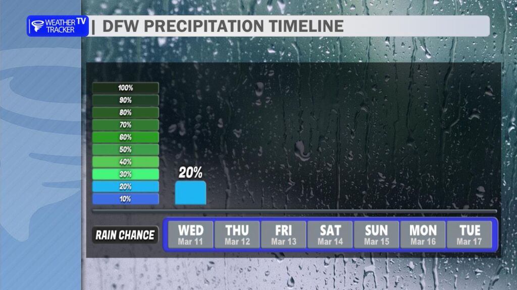
DFW THIS AFTERNOON Mostly sunny with a 20 percent chance of showers and T-Storms. Breezy with highs in the upper 70s. Temperatures falling to around 70 late. North winds 15 to 25 mph. -William

From William Cole: A strong T-Storm will impact portions of southeastern Anderson County through NOON
At 1128 AM , Live Radar was tracking a strong T-Storm 7 miles east of Elkhart, or 14 miles southeast of Palestine, moving northeast at 40 mph.
Wind Gusts Up To 50 Mph. Gusty Winds Could Knock Down Tree Limbs And Blow Around Unsecured Objects.
Stay with William Cole and Weather Tracker TV Dallas – Fort Worth for continuing coverage, online, on our app and on TV. Let’s stay safe together.
Good Wednesday morning, North Texas.
After a very active night of severe weather across North Texas, our weather pattern remains unsettled as we head through the day today.
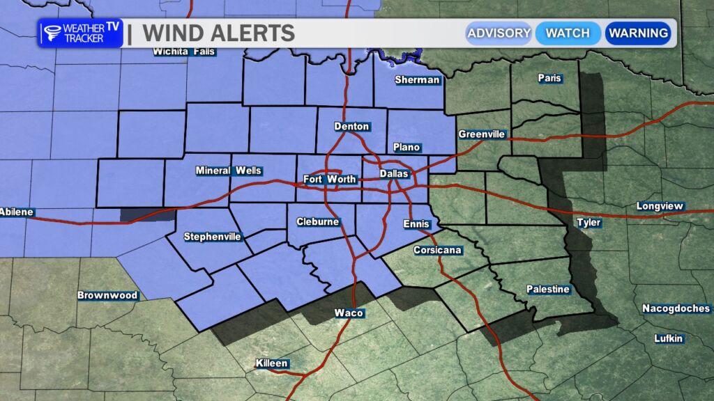
A windy cold front will continue pushing across the region, bringing gusty north winds behind it. Winds will increase through the afternoon with gusts that could exceed 40 mph at times. Because of this, a Wind Advisory is in effect for much of North Texas until 10 PM. Secure any loose outdoor items and use caution if you’ll be driving, especially in high-profile vehicles.
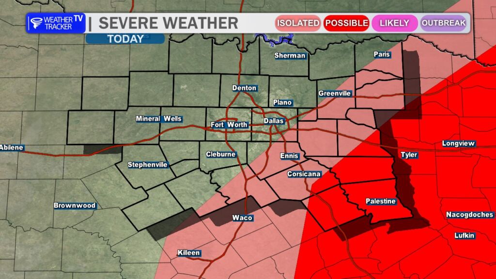
Rain and storm chances will linger into the afternoon, mainly southeast of the Dallas–Fort Worth Metroplex. While the overall severe threat is limited, a few stronger storms cannot be ruled out. The primary hazards would be quarter-size hail and wind gusts up to 60 mph. Most of the activity should gradually move out of the area and weaken by early evening.
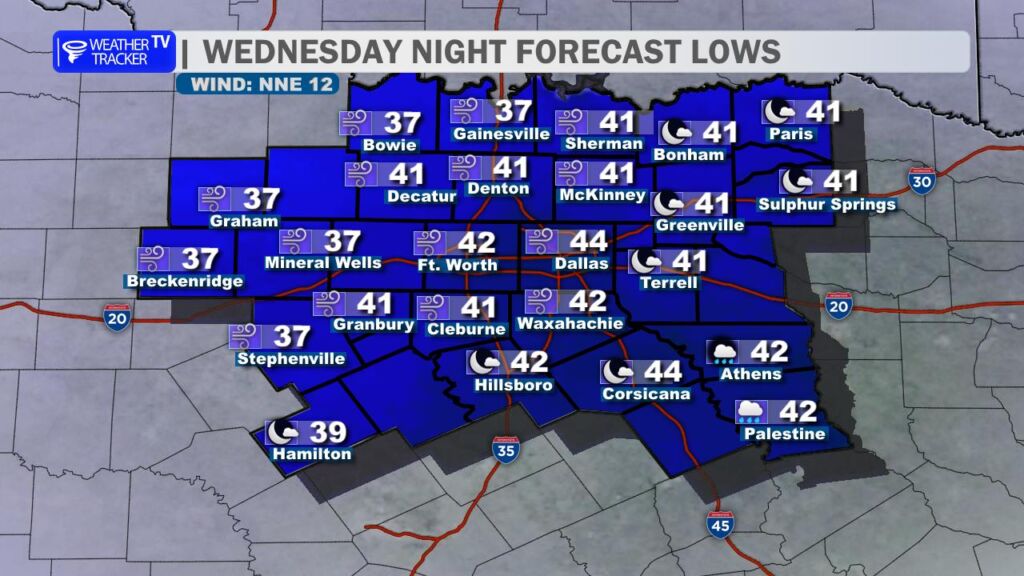
Behind the front, noticeably cooler air settles into North Texas tonight. Overnight temperatures will drop into the 30s and 40s by Thursday morning, making for a much colder start to the day compared to what we’ve experienced recently. You’ll likely want to grab the winter coat on the way out the door Thursday morning.
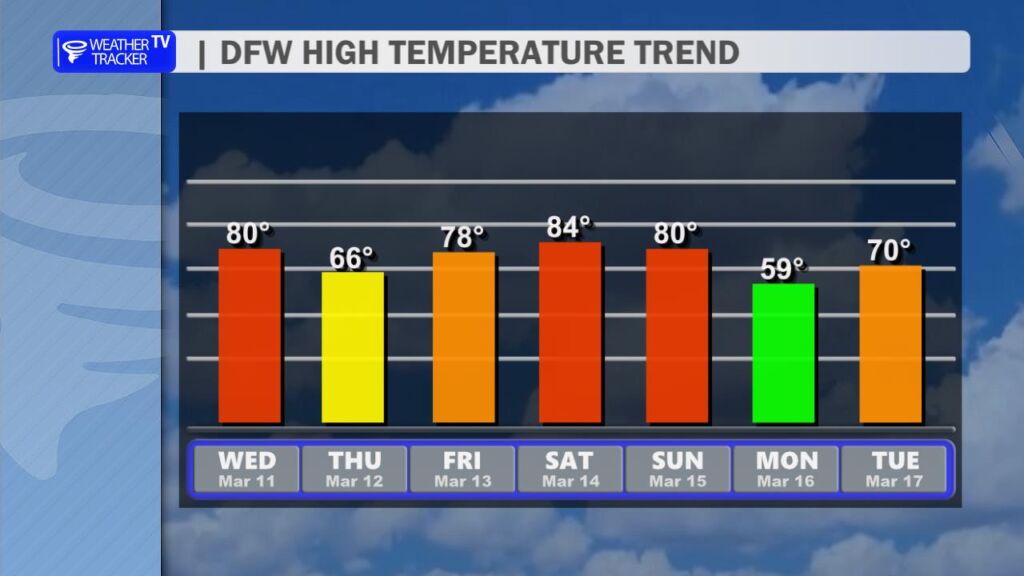
The cooler weather will be brief. Temperatures rebound quickly heading toward the weekend, with highs climbing back toward 80 degrees by Saturday.
Another cold front is expected to arrive late Sunday, bringing another round of cooler air for Monday. At this time, the extended forecast looks quiet and dry across North Texas for the next 7 to 10 days, offering a welcome break after the recent stretch of active weather. -William