ALERT 1:10 PM | Flood Watch expanded until 1:00 PM Sat

Weather Tracker TV DFW Alert

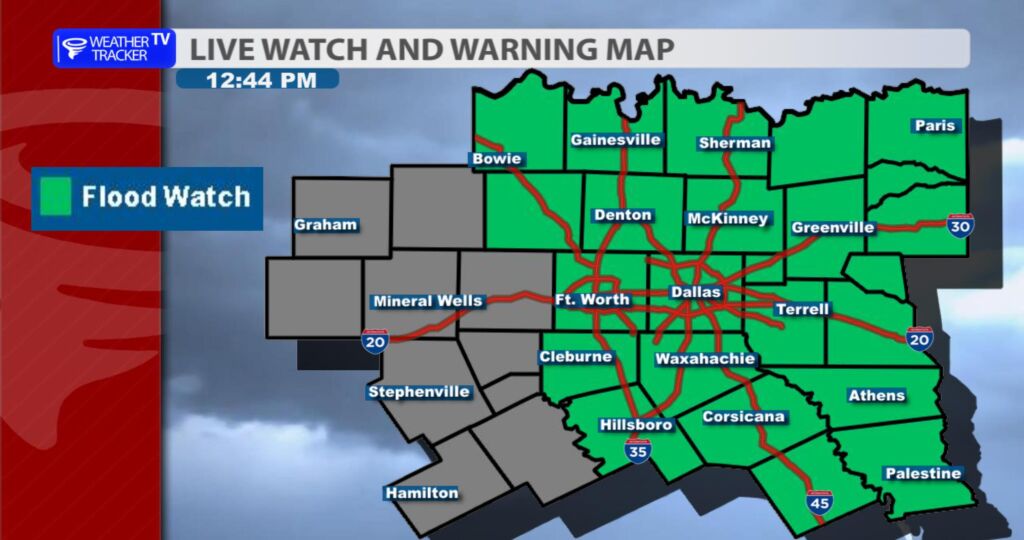
From William Cole: A Flood Watch has been expanded for the following counties in North Texas until 1:00 PM Saturday. Jack.

WHAT Flooding caused by excessive rainfall continues to be possible. WHERE A portion of north central Texas, including the following county, Jack. WHEN From 7 PM this evening through early Saturday afternoon. IMPACTS Excessive runoff may result in flooding of rivers, creeks, streams, and other low-lying and flood-prone locations. ADDITIONAL DETAILS – Rainfall totals of 1 to 3 inches, with isolated higher amounts up to 4 inches.

Stay with William Cole and Weather Tracker TV Dallas – Fort Worth for continuing coverage, online, on our app and on TV.

Your Support Helps

NOW UPDATE | Friday 12:26 AM Jack, Palo Pinto, Stephens & Young Counties

Texas Weather Tracker TV Alert

From William Cole: Strong T-Storms will impact portions of southeastern Young, southwestern Jack, northeastern Stephens and northwestern Palo Pinto Counties through 115 AM

At 1225 AM , Live Radar was tracking strong T-Storms along a line extending from near Graham to near Possum Kingdom State Park. Movement was east at 25 mph.

Winds In Excess Of 30 Mph And Half Inch Hail. Gusty Winds Could Knock Down Tree Limbs And Blow Around Unsecured Objects. Minor Damage To Outdoor Objects Is Possible.

Stay with William Cole and Weather Tracker TV Dallas – Fort Worth for continuing coverage, online, on our app and on TV. Let’s stay safe together.

Your Support Helps

8:58 PM | T-Storm Warning Montague County until 10:00 PM Thursday

Texas Weather Tracker TV Alert

From William Cole: A T-Storm Warning has been issued in the Weather Tracker TV DFW coverage area for Montague County in North Texas until 10:00 PM.

At 857 PM , a severe T-Storm was located near Terral, or 12 miles northeast of Henrietta, moving southeast at 20 mph.

Hometowns Impacted: Nocona Around 935 Pm .

Primary Threats: 60 Mph Wind Gusts And Half Dollar Size Hail.

Stay with William Cole and Weather Tracker TV Dallas – Fort Worth for continuing coverage, online, on our app and on TV. Let’s stay safe together.

Your Support Helps

NOW UPDATE | Thursday 6:11 PM Jack County

Texas Weather Tracker TV Alert

From William Cole: A strong T-Storm will impact portions of southeastern Jack County through 645 PM

At 611 PM , Live Radar was tracking a strong T-Storm near Fort Richardson State Park, or 7 miles south of Jacksboro, moving east at 5 mph.

Nickel Size Hail. Minor Damage To Outdoor Objects Is Possible.

Stay with William Cole and Weather Tracker TV Dallas – Fort Worth for continuing coverage, online, on our app and on TV. Let’s stay safe together.

Your Support Helps

NOW UPDATE | Thursday 5:43 PM Jack, Montague & Wise Counties

Texas Weather Tracker TV Alert

From William Cole: A strong T-Storm will impact portions of southwestern Montague, northwestern Wise and northeastern Jack Counties through 615 PM

At 543 PM , Live Radar was tracking a strong T-Storm near Chico, or 12 miles northwest of Bridgeport, moving northeast at 30 mph.

Nickel Size Hail. Minor Damage To Outdoor Objects Is Possible.

Stay with William Cole and Weather Tracker TV Dallas – Fort Worth for continuing coverage, online, on our app and on TV. Let’s stay safe together.

Your Support Helps

ALERT 12:33 PM | Flood Watch issued until 1:00 PM Sat


From William Cole: A Flood Watch has been issued for the following counties in North Texas until 1:00 PM Saturday. Anderson, Collin, Cooke, Dallas, Delta, Denton, Ellis, Fannin, Freestone, Grayson, Henderson, Hill, Hopkins, Hunt, Johnson, Kaufman, Lamar, Montague, Navarro, Rains, Rockwall, Tarrant, Van Zandt & Wise.

WHAT Flooding caused by excessive rainfall is possible. WHERE Portions of North and Central Texas along and east of the I-35 corridor. WHEN From Friday evening through Saturday afternoon. IMPACTS Excessive runoff may result in flooding of rivers, creeks, streams, and other low-lying and flood-prone locations. Flooding may occur in poor-drainage and urban areas. Creeks and streams may rise out of their banks. ADDITIONAL DETAILS – Rainfall totals of 2 to 3 inches, with isolated higher amounts between 4 to 5 inches.

Stay with William Cole and Weather Tracker TV Dallas – Fort Worth for continuing coverage, online, on our app and on TV.


NOW UPDATE | Saturday 8:20 PM Freestone & Limestone Counties

Texas Weather Tracker TV Alert

From William Cole: A strong T-Storm will impact portions of south central Freestone, northeastern Robertson, southwestern Leon and southeastern Limestone Counties through 845 PM

At 820 PM , Live Radar was tracking a strong T-Storm near Twin Oak Reservoir, or 20 miles north of Hearne, moving east at 40 mph.

Winds In Excess Of 30 Mph And Nickel Size Hail. Gusty Winds Could Knock Down Tree Limbs And Blow Around Unsecured Objects. Minor Damage To Outdoor Objects Is Possible.

Stay with William Cole and Weather Tracker TV Dallas – Fort Worth for continuing coverage, online, on our app and on TV. Let’s stay safe together.

Your Support Helps

NOW UPDATE | Saturday 3:28 PM Hopkins, Hunt & Rains Counties

Texas Weather Tracker TV Alert

From William Cole: A strong T-Storm will impact portions of southern Hunt, southwestern Hopkins and northwestern Rains Counties through 400 PM

At 327 PM , Live Radar was tracking a strong T-Storm near Quinlan, or 13 miles north of Terrell, moving northeast at 75 mph.

Wind Gusts Up To 50 Mph. Gusty Winds Could Knock Down Tree Limbs And Blow Around Unsecured Objects.

Stay with William Cole and Weather Tracker TV Dallas – Fort Worth for continuing coverage, online, on our app and on TV. Let’s stay safe together.

Your Support Helps

2:07 PM | T-Storm Warning Johnson & Tarrant Counties until 2:45 PM Saturday

Texas Weather Tracker TV Alert

From William Cole: A T-Storm Warning has been issued in the Weather Tracker TV DFW coverage area for Johnson & Tarrant Counties in North Texas until 2:45 PM.

At 207 PM , a severe T-Storm was located over Cross Timber, or over Burleson, moving east at 45 mph.

Hometowns Impacted: Fort Worth, Burleson, Crowley, Rendon, And Cross Timber Around 210 Pm . Mansfield Around 215 Pm .

Primary Threats: 60 Mph Wind Gusts And Quarter Size Hail.

Stay with William Cole and Weather Tracker TV Dallas – Fort Worth for continuing coverage, online, on our app and on TV. Let’s stay safe together.

Your Support Helps

NOW UPDATE | Saturday 1:56 PM Johnson & Tarrant Counties

Texas Weather Tracker TV Alert

From William Cole: A strong T-Storm will impact portions of northern Johnson and southeastern Tarrant Counties through 230 PM

At 156 PM , Live Radar was tracking a strong T-Storm over Godley, or near Cleburne, moving east at 50 mph.

Winds In Excess Of 30 Mph And Half Inch Hail. Gusty Winds Could Knock Down Tree Limbs And Blow Around Unsecured Objects. Minor Damage To Outdoor Objects Is Possible.

Stay with William Cole and Weather Tracker TV Dallas – Fort Worth for continuing coverage, online, on our app and on TV. Let’s stay safe together.

Your Support Helps