A Two-Day Soaker is Heading for North Texas

Good Thursday morning, North Texas! Grab the umbrellas and leave a little early for work today. We are settling into a soggy stretch for the next 48 hours as a slow-moving system brings some much-needed spring rain to the region.

The silver lining? We aren’t expecting any severe weather – no sirens today – just a steady, beneficial soak.

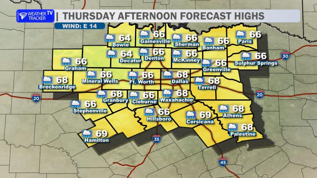
🗓️ Today’s Outlook: Scattered Showers

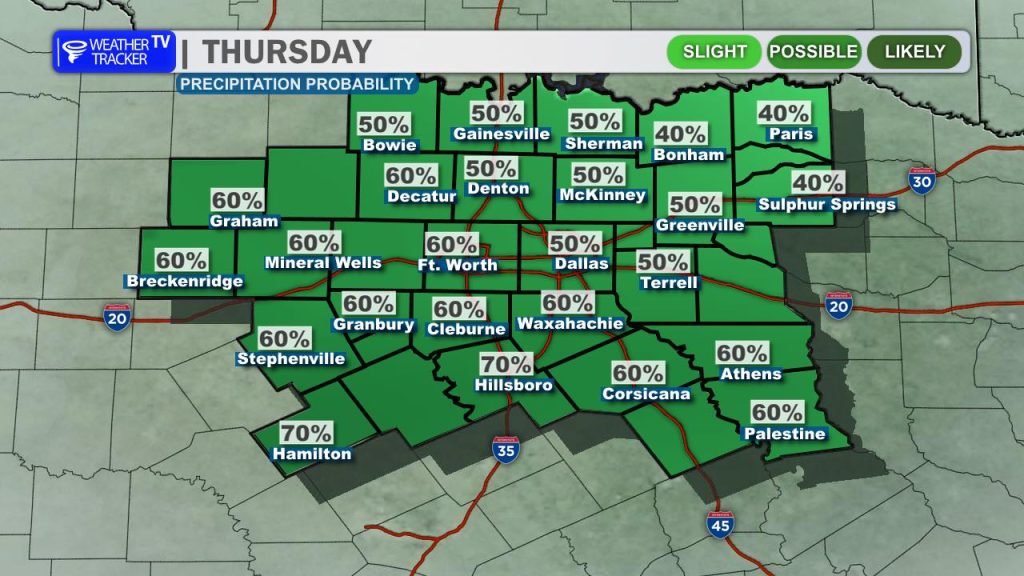
Expect a gray and damp Thursday. Scattered showers will move through the Metroplex on and off throughout the day. Because of the thick cloud cover and persistent rain, temperatures won’t budge much. We’ll see a very tight range today, with highs hovering in the mid-60s areawide.

⚠️ Friday: A Total Washout

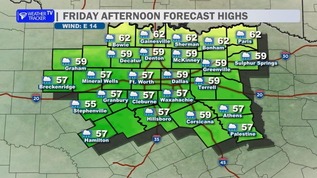
If you have outdoor plans on Friday, you might want a “Plan B.” Friday is shaping up to be a washout from start to finish:

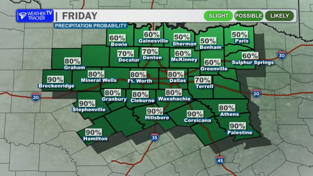
  • Commute Impact: Rain is likely for both the morning and evening drives.
  • Flood Risk: With rain falling consistently, keep an eye out for ponding on the roads and localized flooding in low-lying areas by Friday afternoon.
  • The Chill: It’s going to feel more like late winter than spring. Persistent rain and a north wind will keep most spots stuck in the 50s all day.

📊 Rainfall Totals

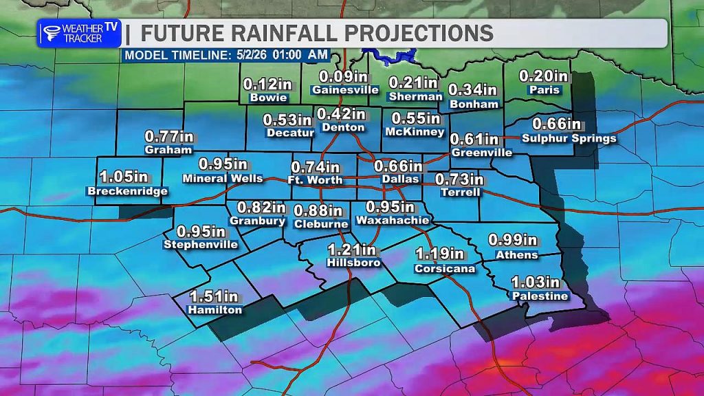
We are looking at some generous totals by the time the clouds break. While everyone gets a drink, the heaviest rain is trending south of the I-20 corridor.

  • General Totals: 0.50″ to 1.00″ for most of the region.
  • Southern Counties: Some spots south of Dallas/Fort Worth could easily see totals climb over 1.5″.

☀️ The Reward: A 5-Star Weekend

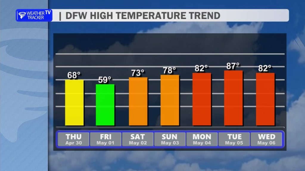
The gloom won’t last forever! We are in for a spectacular weather “payback” starting Saturday morning.

DaySkyHigh Temp
SaturdayClear & SunnyLow 70s
SundayPerfect Spring DayMid 70s
Mon-TueMostly SunnyLow 80s

The warmup continues into next week as we climb back into the 80s. Our next real chance for active weather and potential thunderstorms won’t arrive until next Wednesday.

Today’s DFW Forecast

Gray skies will hang over the Dallas-Fort Worth Metroplex today, with scattered showers around at times and only a small chance for a rumble of thunder. Rain won’t be constant for everyone, but keep the umbrella handy. Highs will stay unusually cool for late April, mostly in the mid to upper 60s with a light northeast breeze.

Tonight, the damp pattern continues with cloudy skies and more showers developing, especially later tonight into early Friday. Temperatures will settle into the middle 50s, so it will feel cool and raw by North Texas standards.

Tomorrow looks like the wetter and cooler day of the stretch. Expect widespread rain through much of Friday with highs struggling to get out of the upper 50s. A few pockets of steadier rain could lead to minor travel slowdowns, especially during the morning and afternoon. Winds will also pick up from the northeast, adding to the chilly feel.

Plan for wet roads and a cool, gloomy finish to the workweek, with Friday bringing the highest rain coverage.

Stay with William Cole & Weather Tracker TV.
Let’s stay safe together.

Today

North Texas Today Forecast

Today- Hourly

Metroplex Hourly Planner

Today – Precipitation

North Texas Today Precipitation Forecast

Tonight

North Texas Tonight Forecast

Tomorrow

North Texas Tomorrow Forecast

9:41 PM Severe Weather Update

A severe thunderstorm warning remains in effect for southeastern Anderson County in North Texas until 10:30 PM. The warning has been canceled for east central Freestone County and northeastern Leon County because the storms have moved out of those areas.

Live Local Radar

**Timing:**
– Warning remains in effect for southeastern Anderson County until 10:30 PM
– At 9:40 PM, severe thunderstorms were located along a line from Maydelle to near Elkhart, moving east at 45 mph
– The warning for east central Freestone County and northeastern Leon County was canceled at 9:40 PM

**What to Expect:**
– Ping pong ball size hail
– Wind gusts up to 60 mph
– At 9:25 PM, half dollar size hail was reported near Elkhart
– Impacted locations include Palestine, Elkhart, Mound City, Denson Spring, Salmon, Cedar Creek, Crystal Lake, Slocum, and Broom City

**Potential Impacts:**
– People and animals outdoors could be injured
– Hail may damage roofs, siding, windows, and vehicles
– Winds may damage roofs, siding, and trees

**What to Do Now:**
– Seek shelter now inside a sturdy structure
– Stay away from windows

Stay with William Cole and Weather Tracker TV.
Let’s stay safe together.

9:25 PM T-Storm Warning

A Severe Thunderstorm Warning is in effect for parts of North Texas until 10:30 PM. The warning includes Anderson County, northeastern Leon County, and east central Freestone County.

Live Local Radar

**Timing:**
– In effect until 10:30 PM
– At 9:25 PM, a severe thunderstorm was near Palestine, moving east at 50 mph

**What to Expect:**
– Ping pong ball size hail
– Wind gusts up to 60 mph
– Radar indicated storm

**Potential Impacts:**
– People and animals outdoors could be injured
– Hail may damage roofs, siding, windows, and vehicles
– Wind may damage roofs, siding, and trees

**What to Do Now:**
– Seek shelter now inside a sturdy structure
– Stay away from windows

Stay with William Cole and Weather Tracker TV.
Let’s stay safe together.

9:17 PM Severe Weather Update

A Severe Thunderstorm Warning remains in effect until 9:30 PM for northeastern Freestone County and central Anderson County in North Texas. This includes Palestine and nearby communities, where severe storms are producing large hail and damaging winds.

Live Local Radar

**Timing:**
– Warning remains in effect until 9:30 PM
– At 9:16 PM, one severe thunderstorm was 10 miles west of Palestine, moving east at 50 mph
– Another severe thunderstorm was 3 miles south of Palestine, moving east at 35 mph

**What to Expect:**
– Golf ball size hail
– Wind gusts up to 60 mph
– This is a dangerous storm
– Thunderstorm damage threat is considerable

**Potential Impacts:**
– People and animals outdoors will be injured
– Hail damage to roofs, siding, windows, and vehicles is expected
– Wind damage to roofs, siding, and trees is expected

**What to Do Now:**
– Prepare immediately for large destructive hail capable of producing significant damage
– Move to shelter inside a strong building
– Stay away from windows

Stay with William Cole and Weather Tracker TV.
Let’s stay safe together.

9:01 PM Severe Weather Update

A severe thunderstorm warning has been canceled for Navarro County, but it remains in effect for Anderson and Freestone counties in North Texas until 9:30 PM. The storm was near Fairfield Lake State Park at 9:00 PM and is moving east at 50 mph.

Live Local Radar

**Timing:**
– Navarro County: The severe thunderstorm warning was canceled at 9:01 PM.
– Anderson and Freestone counties: The warning remains in effect until 9:30 PM.

**What to Expect:**
– Anderson and Freestone counties:
– Golf ball size hail
– Wind gusts up to 60 mph
– At 8:50 PM, golf ball size hail was reported north of Fairfield.
– The storm is considered dangerous.

**Potential Impacts:**
– People and animals outdoors could be injured.
– Hail may damage roofs, siding, windows, and vehicles.
– Wind may damage roofs, siding, and trees.

**What to Do Now:**
– In Anderson and Freestone counties, prepare immediately for large destructive hail capable of causing significant damage.
– Move to shelter inside a strong building and away from windows.

Stay with William Cole and Weather Tracker TV.
Let’s stay safe together.

8:46 PM Severe Weather Update

A severe thunderstorm warning remains in effect until 9:30 PM for northern Freestone, central Anderson, and southeastern Navarro counties in North Texas. At 8:46 PM, the storm was 8 miles northwest of Fairfield and moving east at 40 mph.

Live Local Radar

**Timing:**
– Warning remains in effect until 9:30 PM
– At 8:46 PM, the storm was located 8 miles northwest of Fairfield

**What to Expect:**
– A severe thunderstorm moving east at 40 mph
– Two inch hail
– Wind gusts up to 70 mph
– Radar indicated storm

**Potential Impacts:**
– People and animals outdoors may be injured
– Hail may damage roofs, siding, windows, and vehicles
– Considerable tree damage is expected
– Wind damage is also likely to mobile homes, roofs, and outbuildings

**What to Do Now:**
– This is a dangerous storm
– Prepare immediately for large destructive hail capable of producing significant damage
– Move to shelter inside a strong building and away from windows

Stay with William Cole and Weather Tracker TV.
Let’s stay safe together.

8:35 PM T-Storm Warning

A Severe Thunderstorm Warning is in effect for parts of North Texas until 9:30 PM. The warning includes central Freestone County, central Anderson County, and southeastern Navarro County.

Live Local Radar

**Timing:**
– Issued at 8:34 PM
– In effect until 9:30 PM

**What to Expect:**
– At 8:34 PM, a severe thunderstorm was near Wortham, or 12 miles northeast of Mexia
– The storm is moving east at 45 mph
– Hazards include 60 mph wind gusts and half dollar size hail
– Radar indicated this storm

**Potential Impacts:**
– Hail damage to vehicles is expected
– Wind damage to roofs, siding, and trees is expected

**What to Do Now:**
– Get inside a sturdy structure
– Stay away from windows

Stay with William Cole and Weather Tracker TV.
Let’s stay safe together.