Here is a look at Actual Highs from around North Texas today.

Actual Highs from around the Dallas – Fort Worth Metroplex today.

Today’s complete DFW Almanac.

Here is a look at Actual Highs from around North Texas today.
Actual Highs from around the Dallas – Fort Worth Metroplex today.
Today’s complete DFW Almanac.
Here’s a look at the Monday evening planner for the DFW Metroplex.

A warm and breezy evening is ahead across the Metroplex. Skies will turn mostly cloudy overnight with temperatures holding mild, only falling into the upper 60s. South winds will stay light to occasionally moderate.
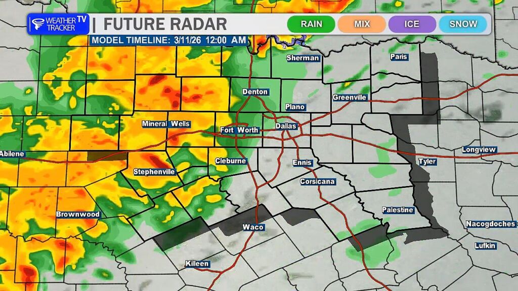
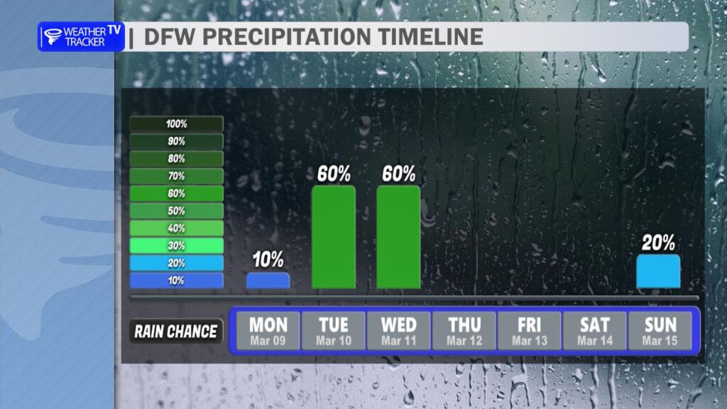
Tuesday brings increasing rain chances as a storm system approaches. Expect mostly cloudy skies with scattered showers and thunderstorms developing, especially during the afternoon. Highs will top out near 80 degrees. While not everyone will see rain during the day, coverage increases significantly Tuesday night. Showers and thunderstorms become widespread after sunset with rain likely continuing through much of the night. A few storms could produce brief heavy downpours.
Wednesday stays unsettled with additional showers and a few storms early, then gradual clearing late in the day as a cold front sweeps through. Winds will shift to the north and become gusty, and temperatures will fall from the 70s into the 60s by afternoon. Much cooler air settles in Wednesday night with lows dropping into the 40s.
Sunshine returns Thursday, followed by a warming trend into the 80s this weekend.
Plan for wet roads Tuesday night and early Wednesday, along with a noticeable midweek cooldown.
Stay with William Cole & Weather Tracker TV.
Let’s stay safe together.
Tonight

Tonight – Precipitation

Tomorrow

Tomorrow – Precipitation

Here’s a look at our Monday evening commute in the DFW Metroplex.


Here’s a look at Live Temperatures across North Texas, MesoScan Radar and the Updated Forecast Map.
DFW TODAY Mostly cloudy this morning, then becoming partly sunny. Warmer with highs in the lower 80s. South winds 5 to 10 mph. -William

Good Monday morning North Texas!
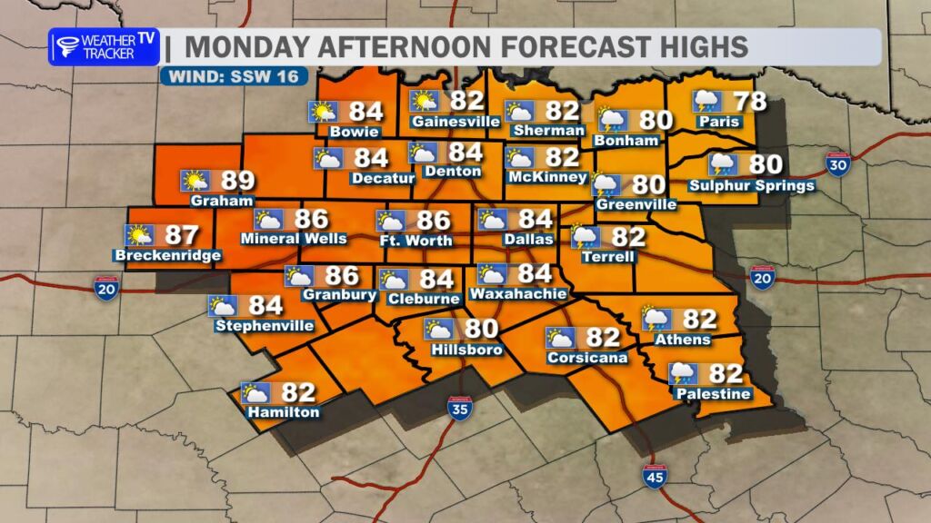
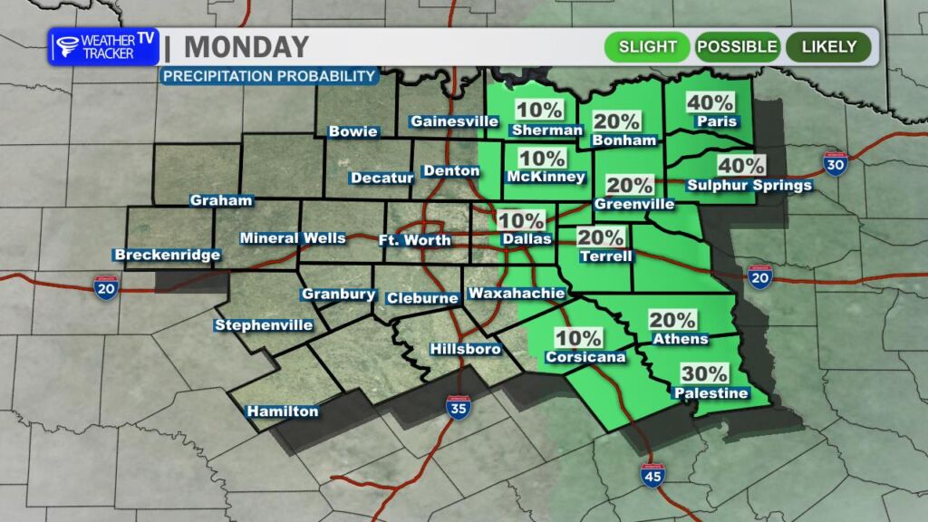
It’s a warm and increasingly humid start to the day across the region, and those muggy conditions will stick around through the afternoon. Expect mostly cloudy skies for much of the day with a mix of clouds and occasional breaks of sun. While most locations will stay dry, a stray shower or thunderstorm cannot be ruled out in our far eastern counties through the early afternoon hours.
Temperatures today will climb well above normal for early March, with afternoon highs pushing into the 80s across North Texas. A steady south wind will continue to pull moisture northward from the Gulf, setting the stage for a more active weather pattern heading into Tuesday.
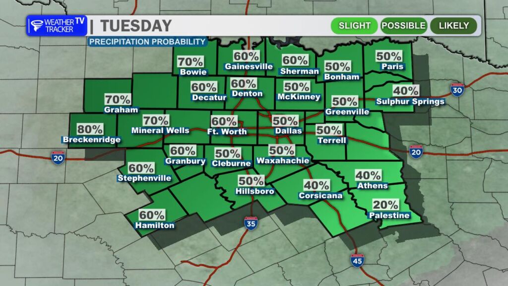
That active pattern arrives tomorrow as rain and thunderstorm chances increase across the region. A few scattered showers could develop during the Tuesday morning commute, but the greater concern for stronger storms will come later in the day.
As we head into the afternoon and evening hours Tuesday, a dryline developing across West Texas will become the primary focus for thunderstorm development. Storms are expected to form along that boundary and move east toward North Texas through the evening.
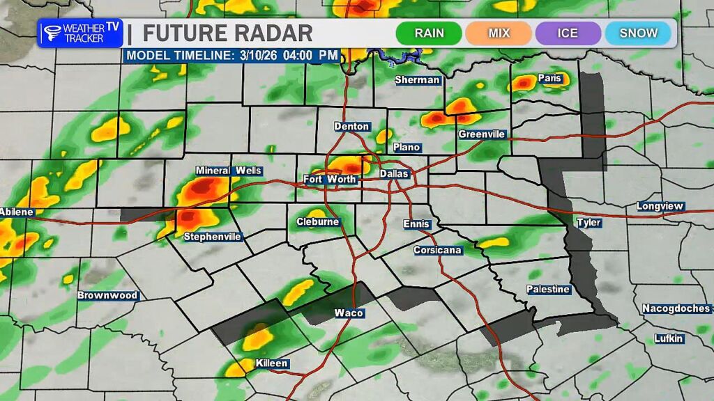
Some of these storms could become severe, bringing the threat of large hail, damaging wind gusts, and possibly a tornado or two Tuesday evening. In addition, storms will have access to abundant Gulf moisture, meaning locally heavy rainfall could accompany the stronger activity.
We are also monitoring a secondary window for storm development ahead of the main line. If isolated storms are able to form east of the dryline after about 4 PM, they could quickly become supercells capable of producing severe weather before the main line of storms arrives later in the evening.
Rain and storm chances may linger into Wednesday, though the overall threat for severe weather should gradually decrease as the system moves east of the region.
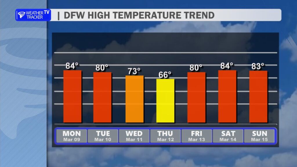
Behind this midweek weather maker, drier and calmer conditions return for the second half of the work week. Temperatures will cool slightly, with highs dropping back into the 60s by Thursday, before a quick warm-up returns by the weekend with 80s making a comeback across North Texas.
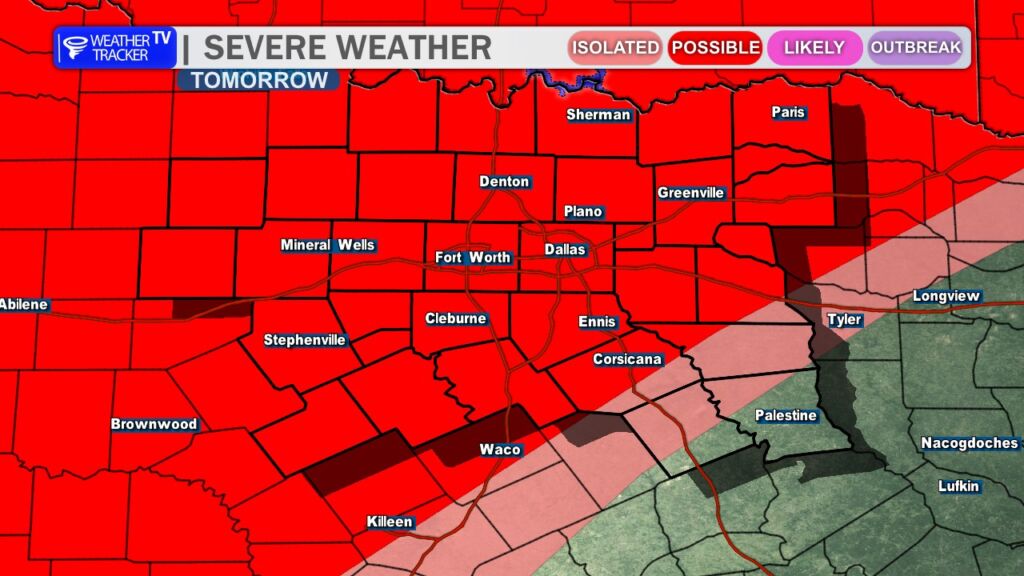
North Texas will be on the western edge of today’s severe weather setup, as a storm system moves out of the Panhandle and tracks east toward the ArkLaTex and Mid-South. The Storm Prediction Center has placed areas east of North Texas in a **Slight Risk (Level 2 of 5)** for severe storms. While the greater risk is just to our east, parts of eastern North Texas could see a few strong storms as this system organizes through the day.

The setup involves a disturbance in the upper atmosphere moving out of the Texas Panhandle this morning. At the same time, warm, humid air is spreading northward across East Texas and the ArkLaTex region. As lift from the upper-level system increases and moisture deepens, thunderstorms are expected to develop and grow into a cluster. The most organized storms are expected from late morning into the afternoon, primarily east of North Texas, but a few storms could clip our eastern counties before shifting farther east into Louisiana, Mississippi, and Alabama.
The main threats with any stronger storms will be **large hail and damaging wind gusts**. The atmosphere will have enough instability and wind shear to support strong updrafts capable of producing hail, especially in the earlier stages before storms merge into a line. As storms cluster together, pockets of strong straight-line winds will become the primary concern. The tornado threat appears low, but not completely zero, particularly with any isolated storms that can briefly rotate. Widespread flooding is not expected, but brief heavy downpours are possible under the strongest cells.
Stay with William Cole and Weather Tracker TV.
Let’s stay safe together.
Here is a look at Actual Lows from around North Texas this morning.

Actual Lows from around the Dallas – Fort Worth Metroplex this morning.

Here’s a look at our Monday planner for the DFW Metroplex.

After a few spotty showers early this morning for parts of North Texas, we’ll see improving conditions through the day. Clouds will gradually break for some sunshine, and it’s going to feel much warmer. Highs across the Dallas–Fort Worth Metroplex climb into the lower to mid 80s with a light south wind increasing slightly this afternoon.
Tonight stays mild and mostly cloudy. Lows will only fall into the upper 60s with a steady south breeze, setting the stage for a more unsettled stretch.
Tuesday turns cloudy with scattered showers and thunderstorms developing, especially during the afternoon. Coverage increases into Tuesday night, when rain becomes likely area-wide with a few embedded storms. Some pockets of heavier rain are possible overnight.
Showers and storms linger into Wednesday before a cold front sweeps through, bringing clearing skies and a noticeable drop in temperatures by Wednesday night. Much cooler air settles in for Thursday with highs back in the 60s.
Plan for wet roads at times Tuesday afternoon through early Wednesday, with brief heavy downpours possible.
Stay with William Cole & Weather Tracker TV.
Let’s stay safe together.
Today
Today – Precipitation
Tonight

Tomorrow
