Here’s a look at our Sunday late evening planner for the DFW Metroplex.

Here’s a look at our Sunday late evening planner for the DFW Metroplex.
Here is a look at Actual Highs from around North Texas today.

Actual Highs from around the Dallas – Fort Worth Metroplex today.

Today’s complete DFW Almanac.

Here’s a look at the Sunday evening planner for the DFW Metroplex.

A quiet and mild night is ahead for the Metroplex. Skies will stay mostly clear with lows settling into the upper 50s. South winds will ease back overnight, making for a comfortable end to the weekend.
Monday looks just as nice. Expect plenty of sunshine with afternoon highs right around 80 degrees in Dallas and Fort Worth. Winds stay light out of the south, and we’ll hold onto that mild pattern Monday night with lows in the lower 60s.
By Tuesday, the warming trend continues. Highs climb into the mid 80s with a stronger south breeze developing in the afternoon. Clouds will begin to increase Tuesday night, setting the stage for a more unsettled stretch.
Rain and storm chances return Wednesday, especially during the afternoon and evening hours. Showers become likely at times through Friday, with several rounds of rain and embedded thunderstorms. While severe weather is not certain, periods of heavy rain and lightning could impact commutes late week. Temperatures stay in the 80s through Friday, then cool into the 70s next weekend as rain continues.
Plan for wet roads and occasional thunderstorms Wednesday through Saturday.
Stay with William Cole & Weather Tracker TV.
Let’s stay safe together.
Tonight

Tonight – Precipitation

Tomorrow

Tomorrow – Precipitation

Here’s a look at our Sunday evening commute in the DFW Metroplex.


Here’s a look at Live Temperatures across North Texas, MesoScan Radar and the Updated Forecast Map.
DFW THIS AFTERNOON Sunny. Highs in the lower 80s. South winds 10 to 15 mph. -William

Good Sunday morning, North Texas!
Today marks the beginning of a noticeable shift in our weather pattern as we transition into a more active stretch over the next several days.
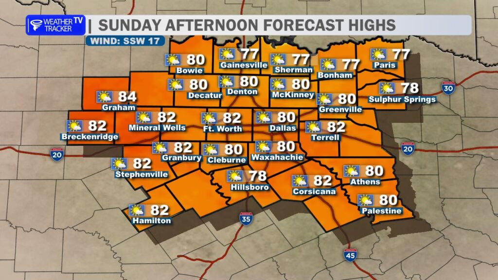
For today, expect warm and breezy conditions under partly cloudy skies. Afternoon highs will climb well into the 80s area-wide – running well above normal for early March. A steady southerly wind at 10 to 20 mph will keep that spring feel in the air.

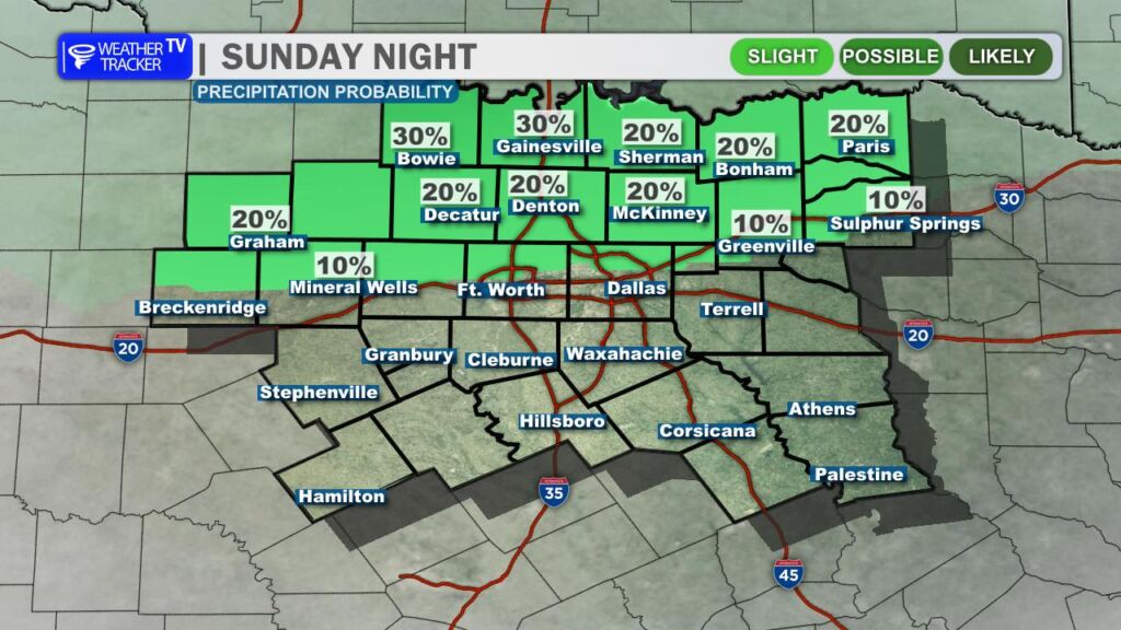
Late this afternoon and evening, scattered showers and thunderstorms are expected to develop across Oklahoma. A few of those storms could drift south toward the Red River late tonight. The better chance for any activity locally would mainly be north of Highway 380, closer to the Red River. Even there, rain chances remain fairly low – around 20 percent – so most locations will stay dry overnight.
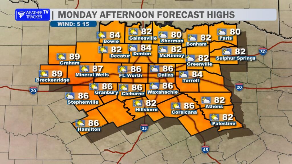
Monday morning will start with a deck of low gray clouds and perhaps a bit of patchy drizzle in spots, but those clouds should gradually lift and break by late morning. Expect increasing sunshine through the afternoon with highs again near 80 degrees. Humidity levels will continue to rise as a southerly wind holds around 10 to 15 mph.
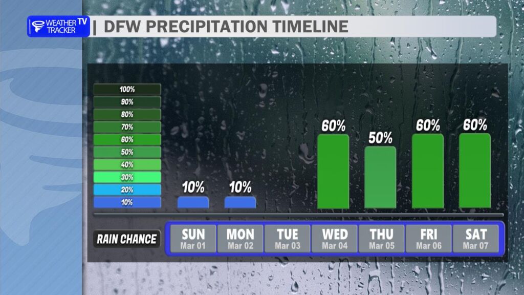
By midweek, the pattern turns more unsettled. Rain and thunderstorm chances increase beginning Wednesday, and several rounds of showers and storms appear possible through next weekend – and potentially even into the following week. This will be a more moisture-rich setup, so locally heavy rainfall and pockets of flooding could become a concern if storms repeatedly move over the same areas.
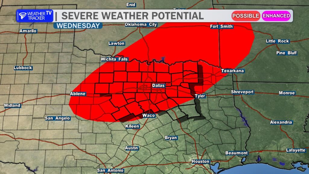
There are also early signals that a few stronger storms could develop during this period. While it’s too soon to pinpoint exact timing or severity, it is worth noting that March 1st marks the climatological start of our spring severe weather season here in North Texas. Now is a good time to review your severe weather safety plan and make sure you have multiple ways to receive warnings on active weather days.
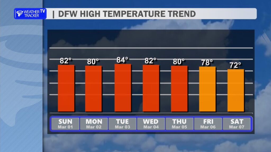
Despite the increasing rain chances, temperatures will remain above normal through much of the week. Highs will stay in the 80s through midweek before gradually easing back into the 70s by next weekend — still mild for this time of year.
We’re entering a much more dynamic stretch of weather, so stay tuned as we fine-tune the timing and impacts in the days ahead. -William
Here is a look at Actual Lows from around North Texas this morning.

Actual Lows from around the Dallas – Fort Worth Metroplex this morning.

Here’s a look at our Sunday planner for the DFW Metroplex.

A warm and quiet start to the weekend across the Dallas–Fort Worth Metroplex.
Today brings mostly sunny skies with just a slim chance for a brief shower early this morning. Any spotty rain will be light and short-lived, with sunshine taking over through the afternoon. Highs climb into the lower 80s with a steady south wind increasing to around 10 to 15 mph, giving us a true spring preview.
Tonight stays mild and mainly clear during the evening, with a few more clouds drifting in late. Lows will settle into the upper 50s with light south winds.
Tomorrow looks very similar to today. Expect plenty of sunshine and afternoon highs back in the lower 80s. South winds will pick up again by afternoon, continuing the warm pattern.
Looking ahead, rain and storm chances return by Tuesday night and especially Wednesday, with scattered thunderstorms possible and a brief cool-down into the mid 70s.
Stay with William Cole & Weather Tracker TV.
Let’s stay safe together.
Today
Today – Precipitation
Tonight

Tomorrow
