Here is a look at Actual Highs from around North Texas today.

Actual Highs from around the Dallas – Fort Worth Metroplex today.

Today’s complete DFW Almanac.

Here is a look at Actual Highs from around North Texas today.
Actual Highs from around the Dallas – Fort Worth Metroplex today.
Today’s complete DFW Almanac.
Here’s a look at the Tuesday evening planner for the DFW Metroplex.

Warm and breezy conditions continue this evening across the Metroplex, with temperatures settling back into the upper 60s overnight. Skies will turn mostly cloudy as Gulf moisture increases, setting the stage for a wetter midweek. South winds will remain light but steady through the night.
Wednesday brings mostly cloudy skies with scattered showers developing late morning, followed by a better chance for showers and thunderstorms during the afternoon and evening. Highs will top out in the upper 70s. Rain chances increase Wednesday night, and a few storms could produce brief heavy downpours as periods of rain continue.
The unsettled pattern sticks around through the end of the week and into the weekend. We’ll see multiple rounds of showers and thunderstorms Thursday through Saturday, with the highest coverage likely Friday into early Saturday. Temperatures stay warm, mainly near 80 through Friday, before cooling into the 70s this weekend.
Plan for several wet periods through Saturday, especially Friday, with occasional heavy rain and lightning possible.
Stay with William Cole & Weather Tracker TV.
Let’s stay safe together.
Tonight

Tonight – Precipitation

Tomorrow

Tomorrow – Precipitation

Here’s a look at our Tuesday evening commute in the DFW Metroplex.


Here’s a look at Live Temperatures across North Texas, MesoScan Radar and the Updated Forecast Map.
DFW THIS AFTERNOON Mostly sunny. Highs in the lower 80s. South winds 10 to 15 mph. -William

Good Tuesday morning, North Texas!
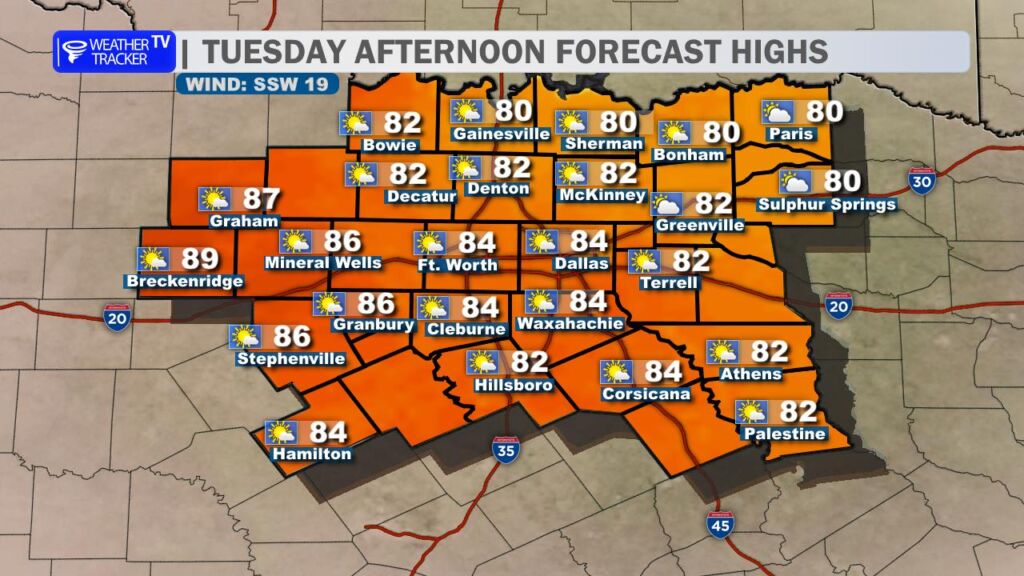
We’re in for another warm, humid, and breezy day across North Texas on this Election Day. Temperatures will climb well into the 80s this afternoon – running above average for early March. A strong south wind will be a noticeable part of the forecast, frequently gusting over 30 mph. That steady southerly flow will act like a conveyor belt, pulling rich Gulf moisture northward and sending humidity levels higher as the day goes on. You’ll definitely feel that mugginess building by late afternoon.
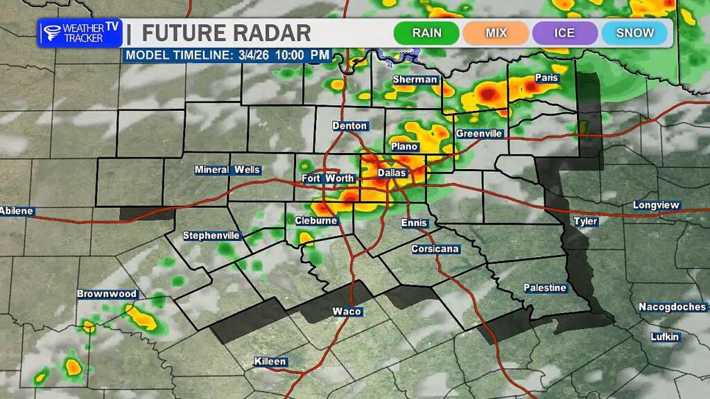
Changes arrive tomorrow as an upper-level storm system swings out into the Southern Plains. As that system approaches, a few showers could develop as early as Wednesday morning, potentially impacting the morning commute. Scattered showers and storms may continue through the afternoon, but our attention really turns to Wednesday evening and overnight.
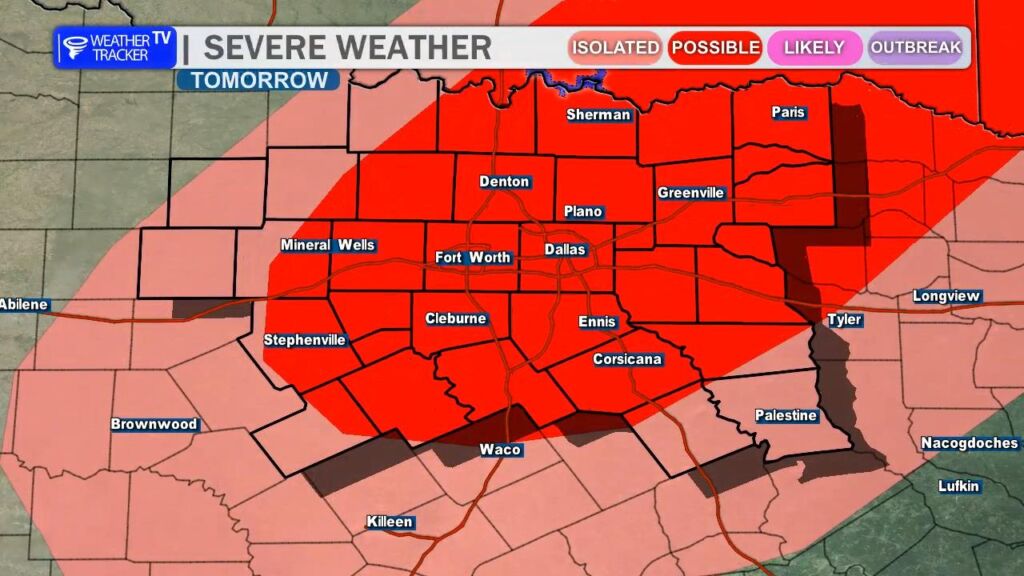
A cold front pushing in from the north will provide the focus for stronger thunderstorms late Wednesday into Wednesday night. Some storms could become severe. The primary concerns will be hail up to half-dollar size and wind gusts approaching 60 mph. While the tornado threat appears low at this time, it is not zero. This is a good reminder to review your severe weather safety plan and make sure you have multiple ways to receive warnings, especially as we head deeper into spring severe weather season here in North Texas.
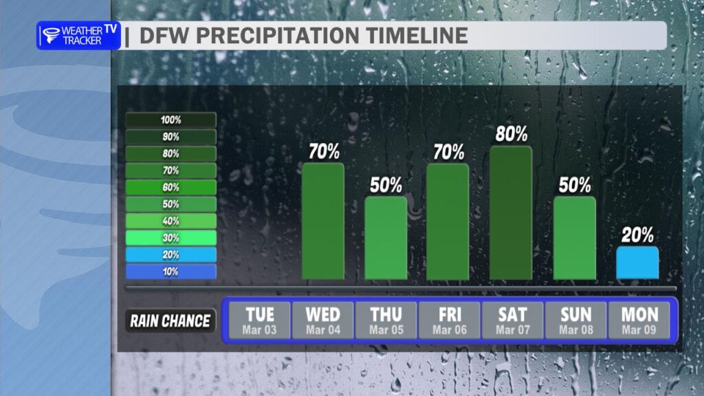
The unsettled pattern doesn’t end there. Additional disturbances are expected later this week, bringing increasing rain and storm chances by Friday into Saturday. Several rounds of rainfall are possible, and with humidity levels remaining high, locally heavy rain could develop. That may lead to some flooding concerns in spots before the system finally moves out.
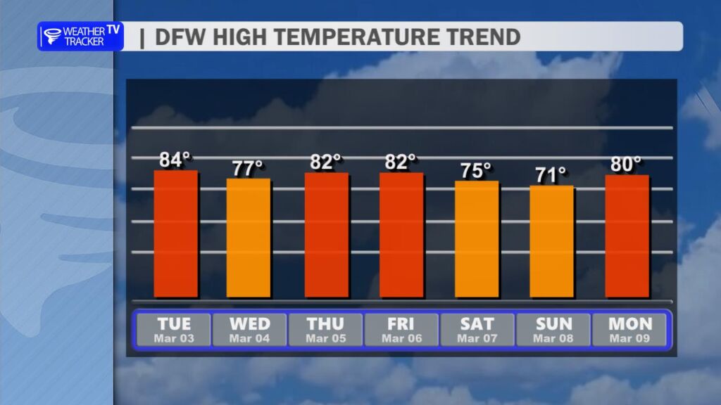
Temperatures will remain above normal through much of the week, with highs generally in the 80s. Behind the late-week system, we’ll see a modest cool-down heading into the weekend, with afternoon highs returning to the 70s – still mild, but a bit more comfortable.
We’ll continue refining the timing and severity details as newer data comes in, so stay tuned for updates. -William
Here is a look at Actual Lows from around North Texas this morning.

Actual Lows from around the Dallas – Fort Worth Metroplex this morning.

Here’s a look at our Tuesday planner for the DFW Metroplex.

It’s another warm and quiet day across the Dallas–Fort Worth Metroplex. Expect a mix of sun and clouds this afternoon with highs climbing into the upper 70s. A light south wind will keep things feeling mild and a bit humid by late day.
Tonight stays partly cloudy and unseasonably warm. Lows will only dip into the lower 60s with a steady south breeze continuing overnight.
Tomorrow turns even warmer. We’ll see a blend of sun and clouds with afternoon highs soaring into the mid 80s. South winds will increase to 10 to 15 mph, occasionally gusty at times, adding to that early spring feel.
Rain chances begin to return late Tuesday night and especially on Wednesday as scattered showers and thunderstorms develop. Storms become more likely Wednesday afternoon and evening, and we’ll keep periodic rain chances in the forecast through the end of the week, with a cooler and wetter setup shaping up by Saturday.
Stay weather-aware mid to late week as multiple rounds of rain and storms could impact commutes.
Stay with William Cole & Weather Tracker TV.
Let’s stay safe together.
Today
Today – Precipitation
Tonight

Tomorrow

Here’s a look at our Tuesday morning commute in the DFW Metroplex.
