Tonight’s DFW Forecast

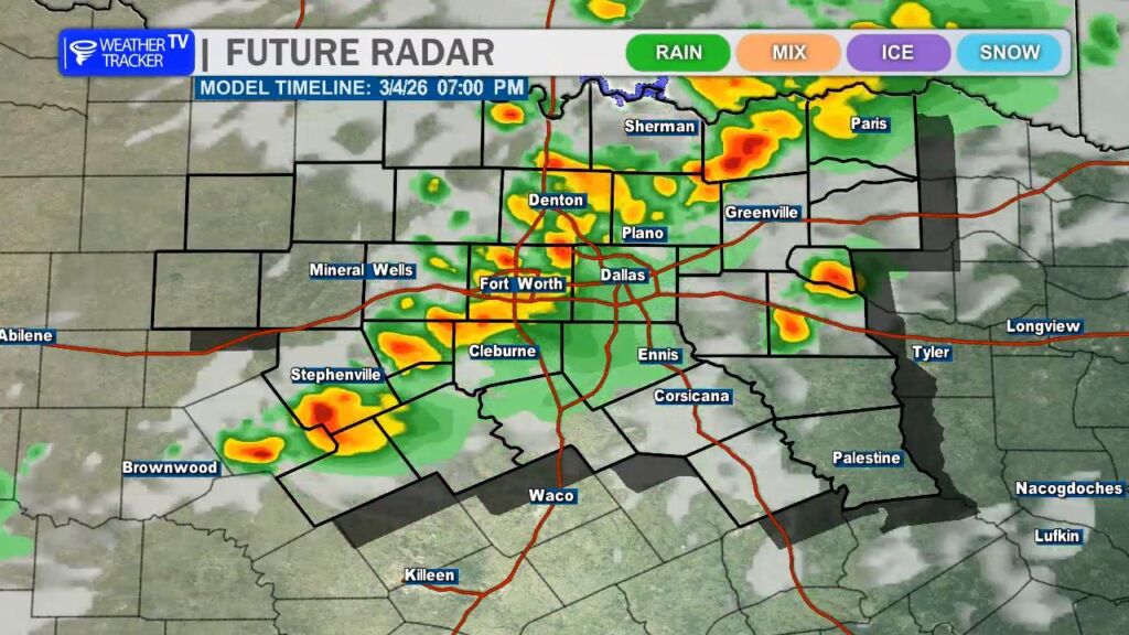
Showers and thunderstorms remain likely across the Metroplex tonight, especially through the evening hours. Rain coverage will gradually taper after midnight, but a few storms may linger into the early morning. It will stay mild and humid with lows settling into the mid 60s and light south winds.

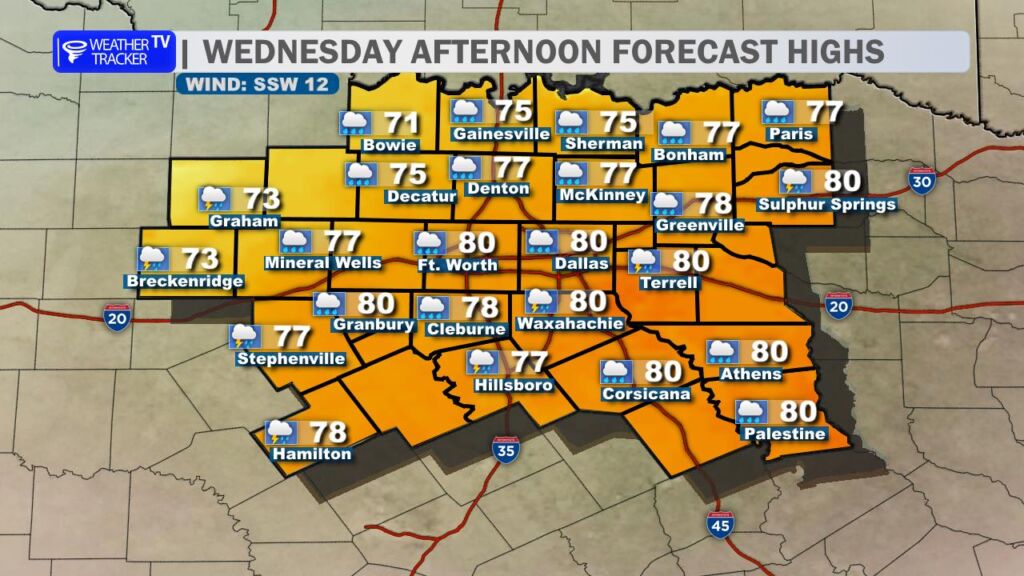
Thursday starts mostly cloudy with a chance for a few morning showers or storms, followed by partial clearing in the afternoon. Even with a few breaks of sun, scattered storms could redevelop later in the day. Highs will return to around 80 with a breezy south wind at 10 to 20 mph.

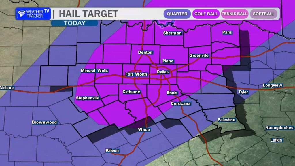
The more active stretch arrives Friday into Saturday. Storm chances ramp up considerably Friday afternoon and evening with widespread rain likely. Some storms could produce heavy downpours. Showers and storms continue Saturday as cooler air filters in, dropping highs into the upper 60s.

Rain chances persist at times Sunday through Tuesday with temperatures gradually warming back into the upper 70s by early next week.

Plan for periods of heavy rain Friday and Saturday that could impact travel.

Stay with William Cole & Weather Tracker TV.
Let’s stay safe together.

Tonight

North Texas Today Forecast

Tonight – Precipitation

North Texas Today Precipitation Forecast

Tomorrow

North Texas Tonight Forecast

Tomorrow – Precipitation

North Texas Tomorrow Forecast

ALERT 4:40 PM | T-Storm Watch until 11:00 PM Wednesday

Texas Weather Tracker TV Alert

From William Cole: A T-Storm Watch has been issued in the Weather Tracker TV DFW coverage area for the following counties until 11:00 PM Wednesday. Collin, Cooke, Dallas, Delta, Denton, Ellis, Fannin, Grayson, Hood, Hopkins, Hunt, Johnson, Kaufman, Lamar, Parker, Rains, Rockwall, Somervell, Tarrant & Wise.

We’ll have Live severe weather coverage on the channel as needed. Be sure to download our free Weather Tracker TV DFW mobile app and add our Live channel to your Roku, Apple or Amazon Fire TV device.

Stay with William Cole and Weather Tracker TV Dallas – Fort Worth for continuing coverage, online, on our app and on TV. Let’s stay safe together.

Your Support Helps

4:37 PM | Flood Advisory Dallas & Tarrant Counties until 6:00 PM

Texas Weather Tracker TV Alert

From William Cole: A Flood Advisory has been issued for Dallas & Tarrant Counties in the Dallas – Fort Worth Metroplex until 6:00 PM. Ponding on the roadways and localized street flooding is possible.

Remember if you see water across a roadway do not drive through it. Turn Around Don’t Drown.

Stay with William Cole and Weather Tracker TV Dallas – Fort Worth for continuing coverage, online, on our app and on TV. Let’s stay safe together.

Your Support Helps

Large Hail Possible with Storms Later Today

Good Wednesday morning, North Texas.

Today is a Weather Ready Day across the region as the threat for severe storms returns to the area.

Through the late morning and early afternoon, we could see scattered showers and a few rumbles of thunder, but the greater concern arrives later in the day. Storm chances will begin to increase after about 4 PM across the Metroplex, unfortunately lining up with the evening commute.

Temperatures this afternoon will climb into a mix of the 70s and lower 80s, depending on cloud cover and how quickly storms begin to develop. A cold front moving in from the northwest will act as the main trigger for thunderstorm development later today, and some storms could develop right over the Metroplex as the front moves through.

Not every storm will be severe, but any storm that becomes strong could quickly reach severe limits. The main threats today will be large hail and strong wind gusts. Hail sizes could range from quarter to half dollar size, and a few isolated reports of golf ball sized hail cannot be ruled out.

The overall tornado threat remains low, but it is not zero. With the amount of wind shear in the atmosphere today, it’s possible that one or two storms could briefly rotate, so a tornado warning or two cannot be completely ruled out.

As always during severe weather season in North Texas, it’s a good idea to review your severe weather safety plan today. Make sure you have a way to receive warnings, especially this evening when many people will be traveling or heading home from work.

And of course, we’ll be monitoring storms closely this afternoon and evening and will bring you updates as needed. -William

Today’s DFW Forecast

After a cloudy start, we’ll see gradual clearing across the Dallas–Fort Worth Metroplex today with a warm south breeze at 10 to 15 mph. Afternoon highs climb into the lower 80s, making for a very spring-like feel.

Tonight stays mild with increasing clouds. A few isolated showers may develop after midnight, but most areas will remain dry. Lows settle into the mid 60s with light south winds continuing.

By Wednesday, rain chances ramp up in a bigger way. Scattered showers are possible during the morning commute, with more widespread showers and thunderstorms developing in the afternoon. Highs will ease back into the mid to upper 70s. Rain chances sit around 70 percent, and a few storms could bring brief heavy downpours.

Plan for wet roads at times Wednesday afternoon and evening, and allow extra time for travel.

Stay with William Cole & Weather Tracker TV.
Let’s stay safe together.

Today

North Texas Today Forecast

Today – Precipitation

North Texas Today Precipitation Forecast

Tonight

North Texas Tonight Forecast

Tomorrow

North Texas Tomorrow Forecast