From William Cole: A TORNADO WATCH has been issued in the Weather Tracker TV DFW coverage area for the following counties in North Texas until 10:00 PM Friday. Collin, Cooke, Dallas, Delta, Denton, Fannin, Grayson, Hopkins, Hunt, Jack, Lamar, Montague, Palo Pinto, Parker, Rockwall, Stephens, Tarrant, Wise & Young.
We’ll have Live severe weather coverage on the channel as needed. Be sure to download our free Weather Tracker TV DFW mobile app and add our Live channel to your Roku, Apple or Amazon Fire TV device.
Stay with William Cole and Weather Tracker TV Dallas – Fort Worth for continuing coverage, online, on our app and on TV. Let’s stay safe together.
Here’s a look at Live Temperatures across North Texas, MesoScan Radar and the Updated Forecast Map.
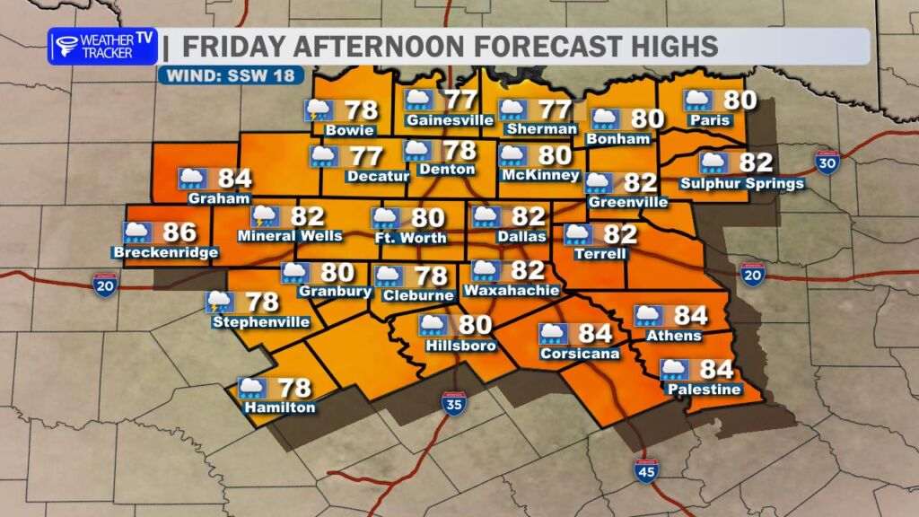
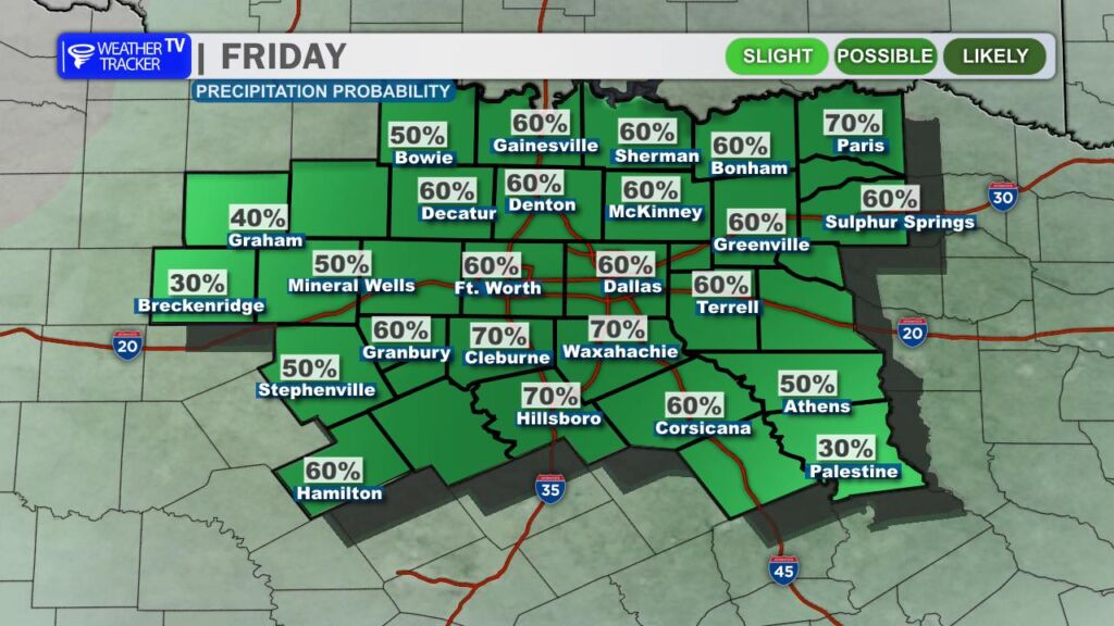
DFW THIS AFTERNOON Mostly cloudy with showers likely with a chance of T-Storms. Highs in the lower 80s. South winds 10 to 20 mph with gusts up to 30 mph. Chance of rain 70 percent. -William
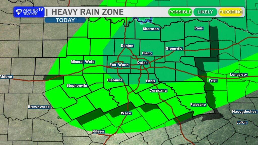
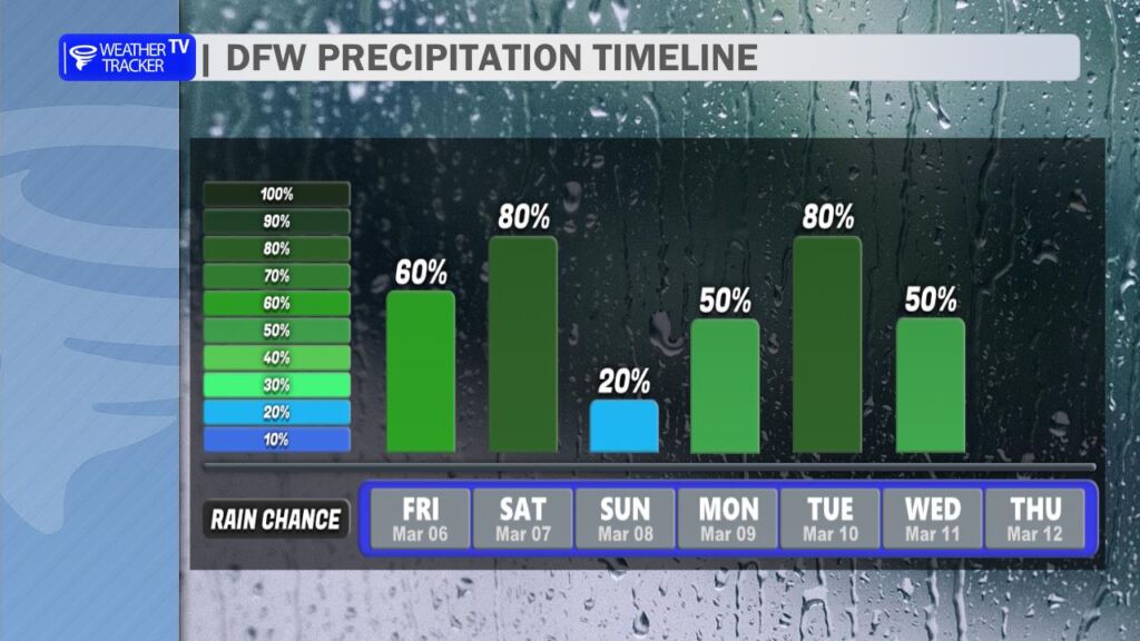
Rain and thunderstorms return to the forecast today and will linger through the first half of the weekend. Scattered showers are expected this morning, but rain coverage will increase through the afternoon as the atmosphere becomes more unstable. Thunderstorms will become more likely later in the day, especially into the late afternoon and evening hours.
Some of these storms could produce locally heavy rainfall, which may lead to isolated flooding issues, particularly in low-lying areas and along roadways that are prone to flooding. If you encounter water over the road, remember to turn around and find an alternate route.
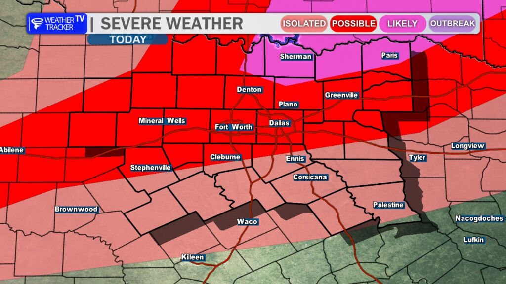
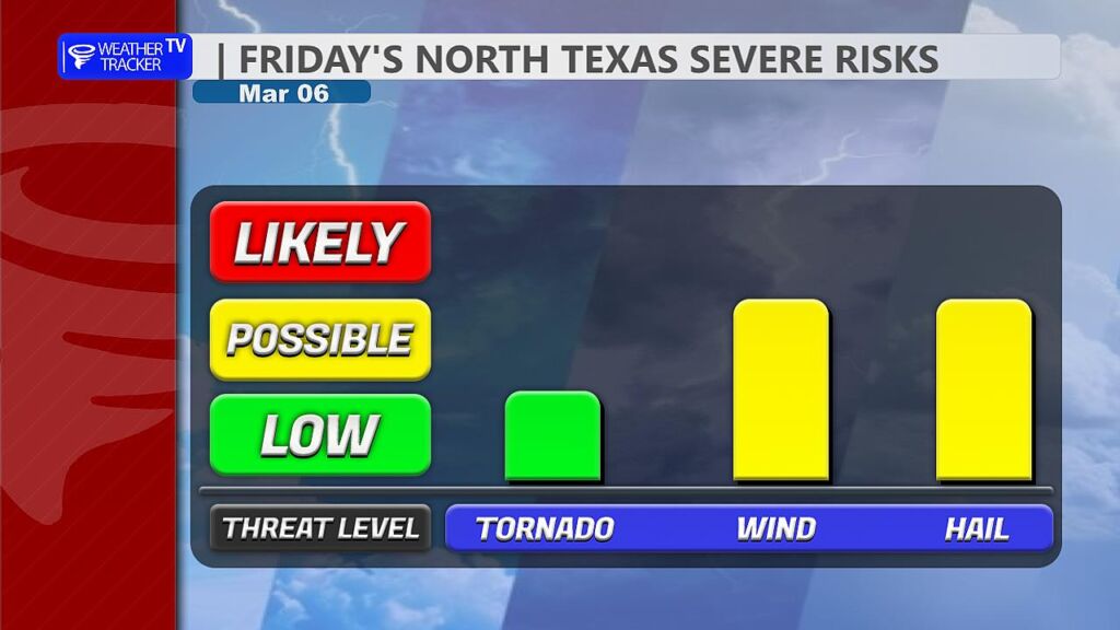
Severe weather is also a concern later this afternoon and tonight. A dryline will begin advancing eastward across North Texas while a strong upper-level storm system approaches from the west. This combination will provide the ingredients necessary for strong to severe thunderstorms. The main threats will be large hail up to the size of golf balls and damaging wind gusts over 65 mph. While the tornado risk remains relatively low, it is not zero, and a tornado warning or two cannot be ruled out.
One limiting factor will be a capping inversion, which may initially suppress storm development. However, if that cap weakens or breaks during the late afternoon or evening hours, storms could rapidly intensify.
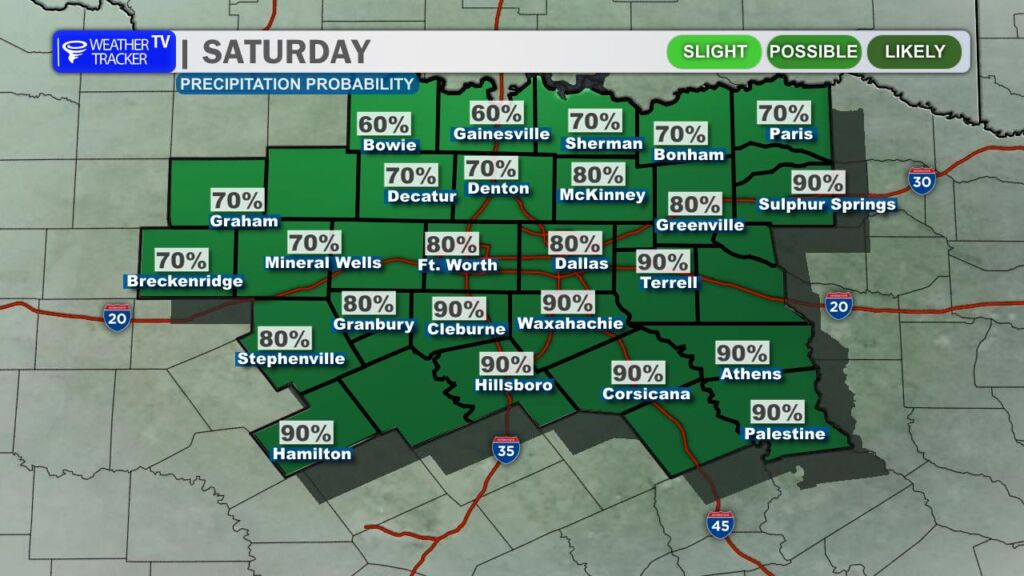
Rain and storm chances continue into Saturday, and periods of heavy rain remain possible. Much of the day could end up being a washout for parts of North Texas, especially if storms repeatedly move over the same areas. Severe weather may also redevelop, particularly south of the I-20 corridor, where hail and strong winds would again be the primary concerns.
We should catch a brief break in the activity on Sunday, but the overall weather pattern remains active. Another storm system is expected to move through early next week, bringing additional chances for rain and thunderstorms Monday and Tuesday.
A warm and unsettled start to the weekend across the Dallas–Fort Worth Metroplex.
Today will be mostly cloudy with scattered showers this morning, becoming more widespread this afternoon. A few thunderstorms are possible at times. It’ll feel breezy and humid, with south winds gusting up to 30 mph and highs reaching the upper 70s to lower 80s. Rain chances sit around 60 to 70 percent, so keep the umbrella handy.
Tonight stays mostly cloudy with periods of showers and a few storms continuing. Lows will settle into the upper 50s to around 60 degrees. Winds ease a bit overnight, but the wet pattern remains in place.
Saturday looks soggy and noticeably cooler. Showers are likely, and a few thunderstorms could mix in, especially during the morning and early afternoon. Highs will start near 70, then temperatures slip into the lower 60s as a cold front pushes through and winds turn north.
Plan for wet roads and reduced visibility at times through Saturday. Allow extra travel time and watch for ponding on streets.
Stay with William Cole & Weather Tracker TV.
Let’s stay safe together.