Here’s a look at our Monday planner for the DFW Metroplex.

Here’s a look at our Monday planner for the DFW Metroplex.
After a few spotty showers early this morning for parts of North Texas, we’ll see improving conditions through the day. Clouds will gradually break for some sunshine, and it’s going to feel much warmer. Highs across the Dallas–Fort Worth Metroplex climb into the lower to mid 80s with a light south wind increasing slightly this afternoon.
Tonight stays mild and mostly cloudy. Lows will only fall into the upper 60s with a steady south breeze, setting the stage for a more unsettled stretch.
Tuesday turns cloudy with scattered showers and thunderstorms developing, especially during the afternoon. Coverage increases into Tuesday night, when rain becomes likely area-wide with a few embedded storms. Some pockets of heavier rain are possible overnight.
Showers and storms linger into Wednesday before a cold front sweeps through, bringing clearing skies and a noticeable drop in temperatures by Wednesday night. Much cooler air settles in for Thursday with highs back in the 60s.
Plan for wet roads at times Tuesday afternoon through early Wednesday, with brief heavy downpours possible.
Stay with William Cole & Weather Tracker TV.
Let’s stay safe together.
Today

Today – Precipitation

Tonight

Tomorrow

Here’s a look at our Monday morning commute in the DFW Metroplex.

Here’s a look at our Sunday late evening planner for the DFW Metroplex.

After a sunny and pleasant afternoon across North Texas, clouds will increase tonight. A few spotty showers or an isolated thunderstorm could pop up after midnight, but most of the Metroplex will stay dry. Lows will be milder, settling into the upper 50s and near 60 with a light south breeze.
Monday turns warmer and more humid. There’s a small window for scattered showers and a rumble of thunder during the morning hours, especially east of Dallas–Fort Worth. By afternoon, we’ll see a mix of clouds and sun with highs climbing into the upper 70s and lower 80s.
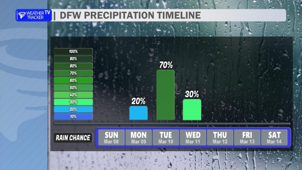
Rain chances ramp up Tuesday as a stronger system approaches. Expect scattered showers developing, with more numerous showers and thunderstorms by late afternoon and into Tuesday night. Some pockets of heavier rain are possible overnight before rain gradually tapers Wednesday. Temperatures will fall through the 70s Wednesday afternoon. Sunshine and cooler air return Thursday, followed by a steady warmup into next weekend with highs back in the 80s.
Plan for wet roads at times late Tuesday into early Wednesday.
Stay with William Cole & Weather Tracker TV.
Let’s stay safe together.
Tonight

Tonight – Precipitation

Tomorrow
Tomorrow – Precipitation
Here is a look at Actual Highs from around North Texas today.

Actual Highs from around the Dallas – Fort Worth Metroplex today.

Today’s complete DFW Almanac.

Here’s a look at the Sunday evening planner for the DFW Metroplex.

Here’s a look at our Sunday evening commute in the DFW Metroplex.


Here’s a look at Live Temperatures across North Texas, MesoScan Radar and the Updated Forecast Map.
DFW THIS AFTERNOON Sunny. Highs in the lower 70s. Light and variable winds. -William

Good Sunday morning, North Texas!
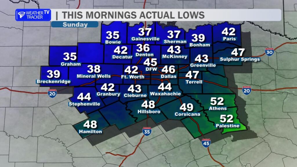
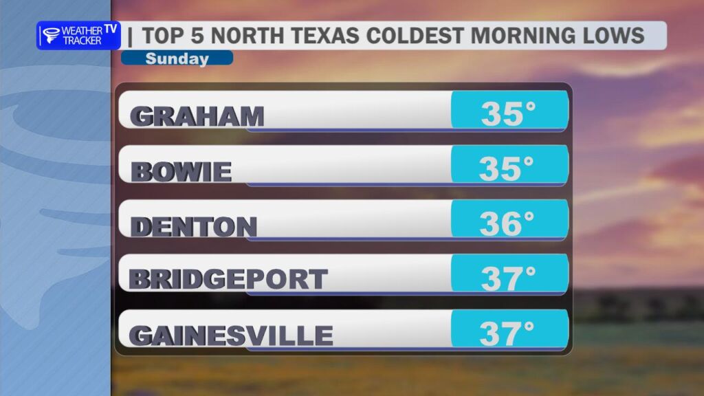
After an active stretch of weather across the region over the past couple of days, North Texas gets a well-deserved break today. A cold front pushed through the area yesterday, and you could certainly feel the difference this morning. Temperatures started the day noticeably cooler, with most locations waking up in the 40s and a few spots northwest of the Dallas–Fort Worth Metroplex dipping into the upper 30s.
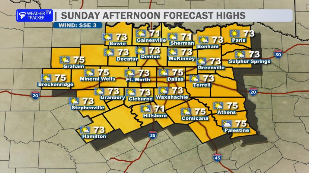
Despite the cool start, today will turn out to be a very pleasant day across the region. Expect plenty of sunshine through the afternoon with highs climbing into the 70s. Winds will remain light and variable, making for a comfortable day across North Texas.
Enjoy the quiet weather while it lasts, because the pattern turns more active again as we head into the upcoming work week.
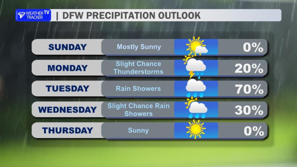
Rain and thunderstorm chances begin increasing late Monday night and especially into Tuesday afternoon, Tuesday night, and early Wednesday. A strong upper-level storm system moving out of the Southwest will interact with warm, humid air returning from the Gulf, creating favorable conditions for widespread showers and thunderstorms.
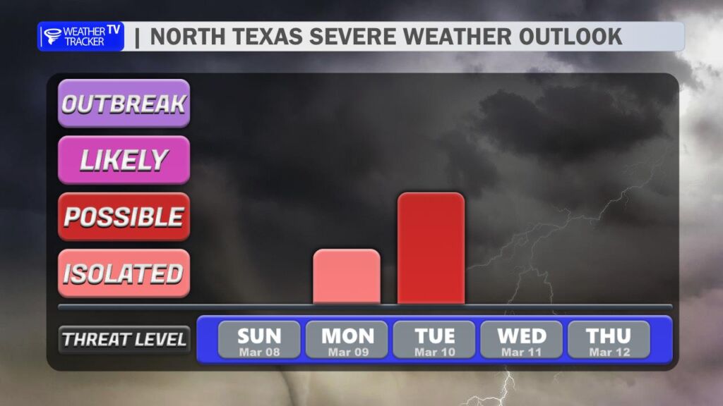
Periods of heavy rain will be possible, and there is also the potential for severe weather Tuesday afternoon and evening. At this point, all modes of severe weather appear possible, including large hail, damaging wind gusts, and a lower-end tornado risk. It will be something to keep an eye on as we move closer to midweek.
Once this storm system moves out of the region by Wednesday, rain and storm chances begin to taper off for the remainder of the week. Cooler air will settle in behind the system with highs falling back into the 60s on Thursday.
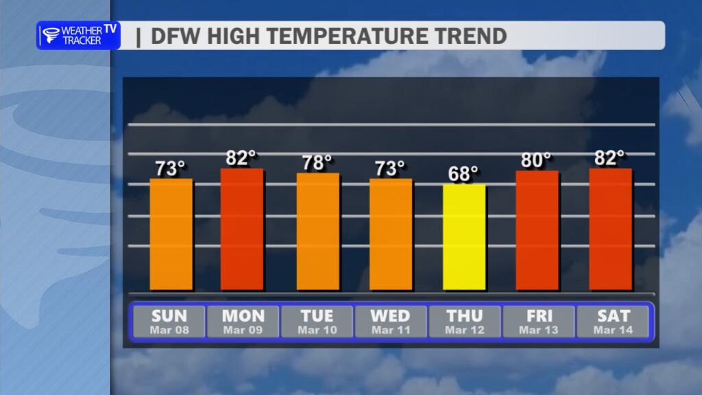
The cooler weather won’t last long, however. Temperatures rebound quickly late in the week and heading into next weekend, with highs climbing back into the 80s across North Texas.