Extreme Winds and Critical Fire Danger Expected Across North Texas Today

Good Sunday morning, North Texas.

It’s a mild start to the morning, but big changes are on the way today. A powerful cold front will sweep across North Texas this afternoon, bringing extremely strong winds and falling temperatures.

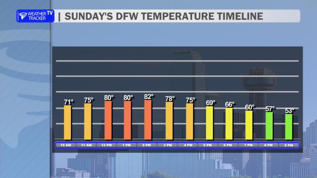
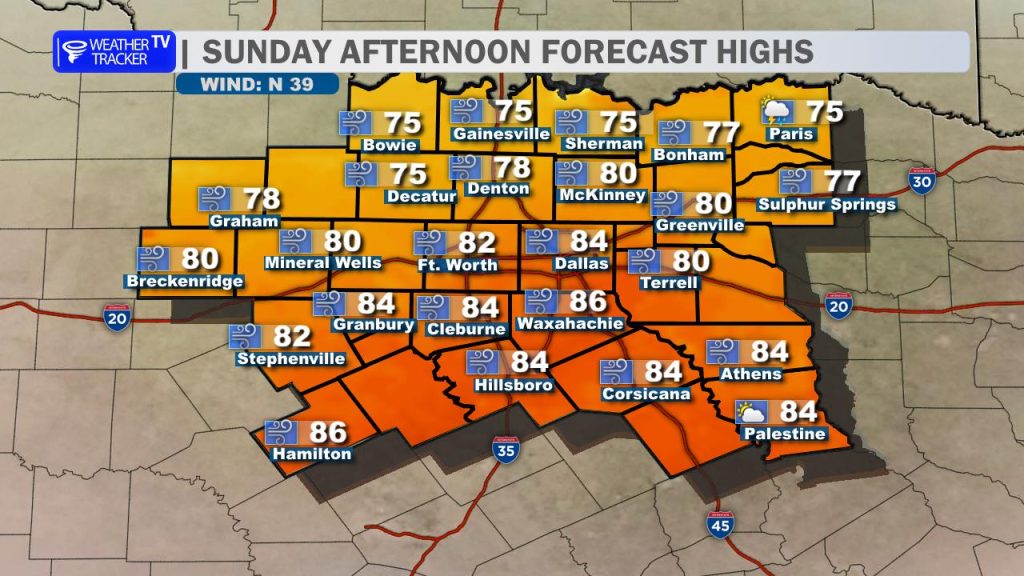
Temperatures will climb into the 70s and even low 80s early today, but once the cold front passes, readings will begin to drop quickly through the afternoon. The expected timing for the DFW Metroplex is between Noon and 2 PM.

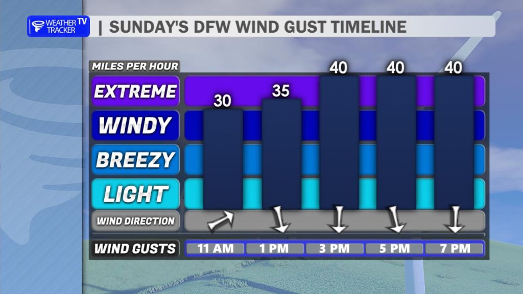
The biggest story today will be the wind. Wind gusts between 40 and 50+ mph are expected as the front moves through. Be sure to secure loose outdoor items such as patio furniture, trash cans, and decorations. If you’re driving a high-profile vehicle, use extra caution, especially on west–east highways, where strong crosswinds could make travel difficult.

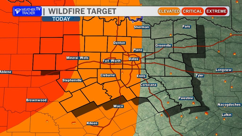
Because of the combination of strong winds, dry air, and warm temperatures ahead of the front, fire danger will be critical across much of North Texas today. Outdoor burning is strongly discouraged. Even a small spark could quickly turn into a fast-moving grass fire under these conditions. Avoid activities that could produce sparks, such as welding or using equipment that could ignite dry grass. If you see smoke or fire, call 911 immediately, as any fires that start today could spread rapidly.

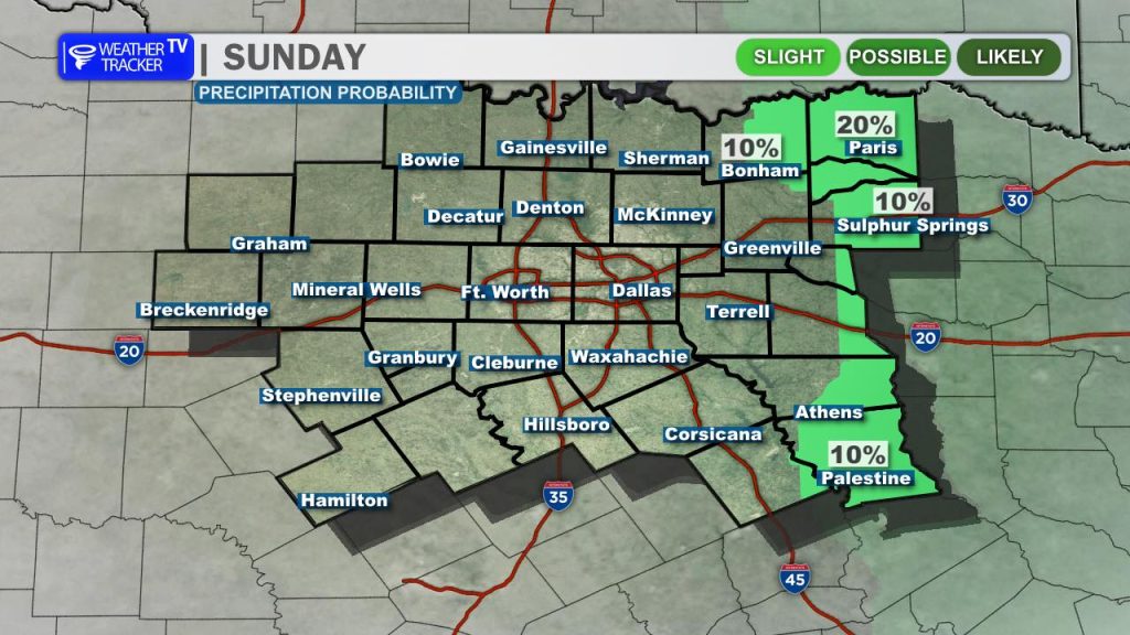
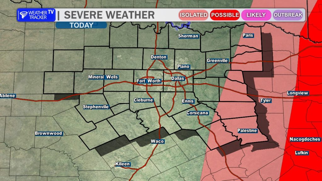
There is also a slight chance for a thunderstorm to develop along the cold front, mainly across our eastern counties later this afternoon. While rain chances remain low – only 10 to 20 percent – any storm that forms could briefly become strong to severe, producing quarter-size hail and wind gusts up to 60 mph.

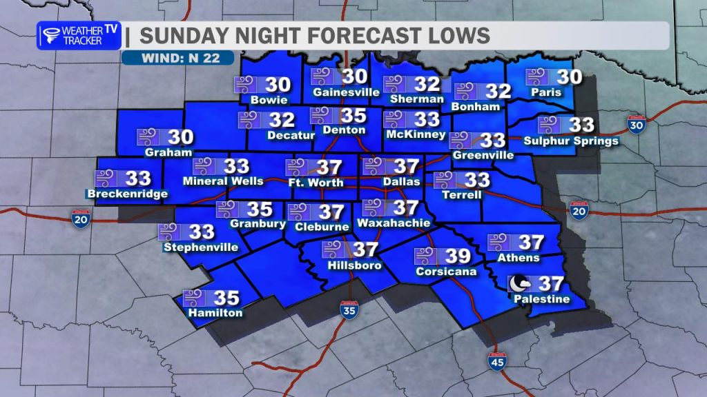
Behind the front, much colder air moves in tonight. Overnight lows will drop into the 30s, and a freeze is possible north and west of the Dallas–Fort Worth Metroplex, especially along the Red River Valley.

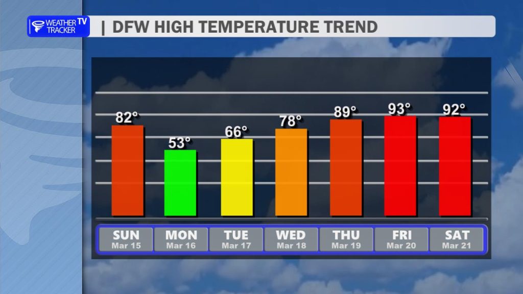
The good news is the winds will gradually decrease by sunrise Monday. Monday itself will be a chilly day, with highs only reaching the 50s, but temperatures rebound quickly through the week with highs returning to the 70s and even 80s by mid to late week.

11:51 AM | Wind Advisory until 1:00 AM Monday

Texas Weather Tracker TV Alert

From William Cole: A Wind Advisory has been issued in the Weather Tracker TV DFW coverage area from 2:00 PM Sunday until 1:00 AM Monday for Anderson, Freestone, Henderson & Van Zandt Counties in North Texas.

Northwest winds 20 to 30 mph with gusts up to 45 mph expected.

Stay with William Cole and Weather Tracker TV Dallas – Fort Worth for continuing coverage, online, on our app and on TV. Let’s stay safe together.

Your Support Helps

11:51 AM | Wind Advisory until 1:00 AM Monday

Texas Weather Tracker TV Alert

From William Cole: A Wind Advisory has been issued in the Weather Tracker TV DFW coverage area from 7:00 AM Sunday until 1:00 AM Monday for Bosque, Collin, Cooke, Dallas, Delta, Denton, Ellis, Erath, Fannin, Grayson, Hamilton, Hill, Hood, Hopkins, Hunt, Jack, Johnson, Kaufman, Lamar, Montague, Navarro, Palo Pinto, Parker, Rains, Rockwall, Somervell, Stephens, Tarrant, Wise & Young Counties in North Texas.

Northwest winds 25 to 35 mph with gusts up to 50 mph expected.

Stay with William Cole and Weather Tracker TV Dallas – Fort Worth for continuing coverage, online, on our app and on TV. Let’s stay safe together.

Your Support Helps

DFW Early Wednesday Afternoon Update

Texas Weather Tracker TV Alert

Here’s a look at Live Temperatures across North Texas, MesoScan Radar and the Updated Forecast Map.

DFW THIS AFTERNOON Mostly sunny with a 20 percent chance of showers and T-Storms. Breezy with highs in the upper 70s. Temperatures falling to around 70 late. North winds 15 to 25 mph. -William

Texas Weather Tracker TV Alert

Texas Weather Tracker TV Alert

NOW UPDATE | Wednesday 11:29 AM Anderson County

Texas Weather Tracker TV Alert

From William Cole: A strong T-Storm will impact portions of southeastern Anderson County through NOON

At 1128 AM , Live Radar was tracking a strong T-Storm 7 miles east of Elkhart, or 14 miles southeast of Palestine, moving northeast at 40 mph.

Wind Gusts Up To 50 Mph. Gusty Winds Could Knock Down Tree Limbs And Blow Around Unsecured Objects.

Stay with William Cole and Weather Tracker TV Dallas – Fort Worth for continuing coverage, online, on our app and on TV. Let’s stay safe together.

Your Support Helps