Here’s a look at our Saturday late evening planner for the DFW Metroplex.

Here’s a look at our Saturday late evening planner for the DFW Metroplex.
Here is a look at Actual Highs from around North Texas today.

Actual Highs from around the Dallas – Fort Worth Metroplex today.

Today’s complete DFW Almanac.

Here’s a look at the Saturday evening planner for the DFW Metroplex.

North Texas will turn chilly tonight as clear skies and lighter winds allow temperatures to fall quickly. Expect lows in the mid to upper 30s across the Dallas–Fort Worth Metroplex, with some upper 20s and lower 30s in outlying areas by early Sunday morning.
Sunday stays bright but cool. Afternoon highs will top out in the upper 50s with light north winds. Sunday night looks even colder, with many spots dropping to around freezing by early Monday.
Monday remains sunny and cool, with highs again in the upper 50s. After that, a steady warming trend begins. Temperatures climb into the low 70s Tuesday, then surge into the upper 70s and lower to mid 80s by Wednesday under partly to mostly sunny skies. Late week brings another dry cold front, easing highs back into the 70s Thursday and Friday with cooler mornings in the 40s.
Cold mornings through Monday may require a jacket and protection for sensitive plants. Warmer springlike weather returns quickly by midweek.
Stay with William Cole & Weather Tracker TV.
Let’s stay safe together.
Tonight

Tonight – Precipitation

Tomorrow

Tomorrow – Precipitation

Here’s a look at our Saturday evening commute in the DFW Metroplex.


Here’s a look at Live Temperatures across North Texas, MesoScan Radar and the Updated Forecast Map.
DFW THIS AFTERNOON Sunny. Highs in the mid 60s. North winds 15 to 20 mph. -William

Happy Saturday, North Texas!

We’re in for a bright but cooler afternoon across the region. Sunshine will dominate the sky, but temperatures will only climb into the 50s and 60s area-wide. A brisk northerly wind gusting over 35 mph at times will make it feel noticeably cooler, especially in open areas. If you’re heading out today, a light jacket will definitely come in handy.

As we move into the evening hours, winds will gradually diminish after sunset. Expect a quiet and seasonably chilly night. Temperatures in the Metroplex will settle into the 50s around 8 PM, then drop into the mid-40s by midnight. Rural communities will likely slip a few degrees cooler.
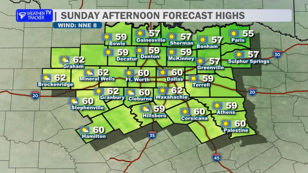
Sunday brings a similar setup. Highs will once again top out in the 50s and 60s under partly cloudy skies. A north breeze will increase during the day, adding a bit of an edge to the air. While it won’t be as windy as Saturday, it will still feel cool.
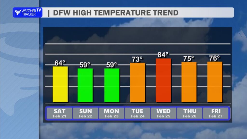
Looking ahead, a big warm-up is on the way. Temperatures steadily rebound through early next week, with highs surging back into the 80s by Wednesday. That warming trend, combined with dry conditions and increasing winds, may elevate wildfire concerns across parts of North Texas. It’s something we’ll be monitoring closely.
For now, the forecast remains dry through the next 7 to 10 days – a stretch of quiet weather ahead. -William
Here is a look at Actual Lows from around North Texas this morning.

Actual Lows from around the Dallas – Fort Worth Metroplex this morning.

Here’s a look at our Saturday planner for the DFW Metroplex.

North Texas is waking up to a bright and quiet Saturday. Expect plenty of sunshine across the Dallas–Fort Worth Metroplex with afternoon highs in the low to mid 60s. A steady north wind at 10 to 15 mph will make it feel a bit cooler at times, especially later today.
Tonight, skies stay clear but temperatures drop off quickly. Lows will fall into the mid 30s across DFW, with a light north breeze continuing before easing after midnight. If you’re out late or heading out early Sunday, it’ll feel chilly.
Sunday brings another round of full sunshine with highs near 60 degrees. Winds remain light out of the north, keeping the cool air in place. Clear skies Sunday night will allow temperatures to dip to around freezing in some spots.
Looking ahead, we stay sunny and cool Monday before a warming trend kicks in. Highs climb into the 70s by Tuesday and push into the 80s by midweek.
Stay with William Cole & Weather Tracker TV.
Let’s stay safe together.
Today
Today – Precipitation
Tonight

Tomorrow
