Here is a look at Actual Highs from around North Texas today.

Actual Highs from around the Dallas – Fort Worth Metroplex today.

Today’s complete DFW Almanac.

Here is a look at Actual Highs from around North Texas today.
Actual Highs from around the Dallas – Fort Worth Metroplex today.
Today’s complete DFW Almanac.
Here’s a look at the Sunday evening planner for the DFW Metroplex.

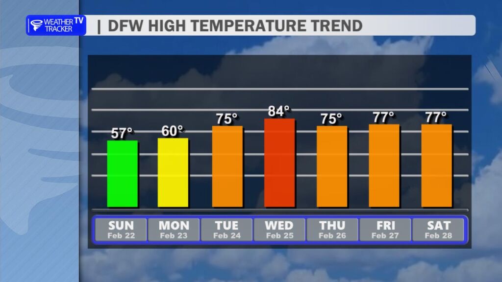
It’s a clear and cool night ahead across the Dallas–Fort Worth Metroplex. Skies stay mostly clear with light north winds, and temperatures will drop into the lower 30s by morning. Some of our northern counties could briefly dip into the upper 20s, so it’ll be a cold start Monday.
Monday looks beautiful with plenty of sunshine and highs near 60 degrees. Winds will be light, shifting around to the southeast by afternoon. Monday night won’t be as chilly, with lows settling closer to 40 degrees as southerly winds return.
A big warm-up begins Tuesday. Highs climb into the lower to mid 70s with gusty south winds increasing through the afternoon, occasionally gusting up to 30 mph. Even warmer air builds in Wednesday with highs soaring into the 80s area-wide under mostly sunny skies. A dry cold front late Wednesday into Thursday brings slightly cooler air, but we stay sunny with highs in the 70s heading into next weekend.
Stay with William Cole & Weather Tracker TV.
Let’s stay safe together.
Tonight

Tonight – Precipitation

Tomorrow

Tomorrow – Precipitation

Here’s a look at our Sunday evening commute in the DFW Metroplex.


Here’s a look at Live Temperatures across North Texas, MesoScan Radar and the Updated Forecast Map.
DFW THIS AFTERNOON Sunny. Highs in the upper 50s. North winds 5 to 10 mph. -William

Happy Sunday, North Texas!
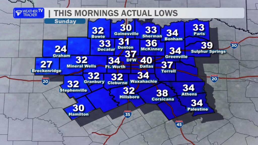
It’s a cold start across the region this morning. Most communities woke up to temperatures in the 30s, and a few spots west of the Dallas–Fort Worth Metroplex dipped to or just below the freezing mark. If you were out early, you definitely felt that late-winter chill in the air.
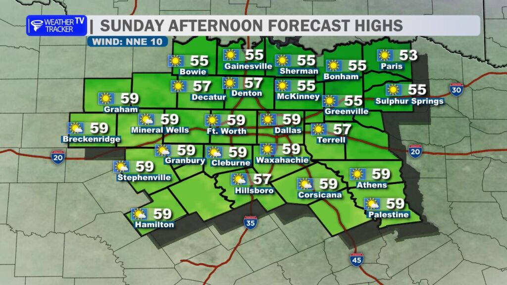
The good news? Sunshine returns in full force today. Expect bright blue skies from start to finish with afternoon highs climbing into the 50s area-wide. Even with the sunshine, a steady north breeze will keep things feeling brisk through much of the day, so you may still want that jacket if you’re heading outdoors.
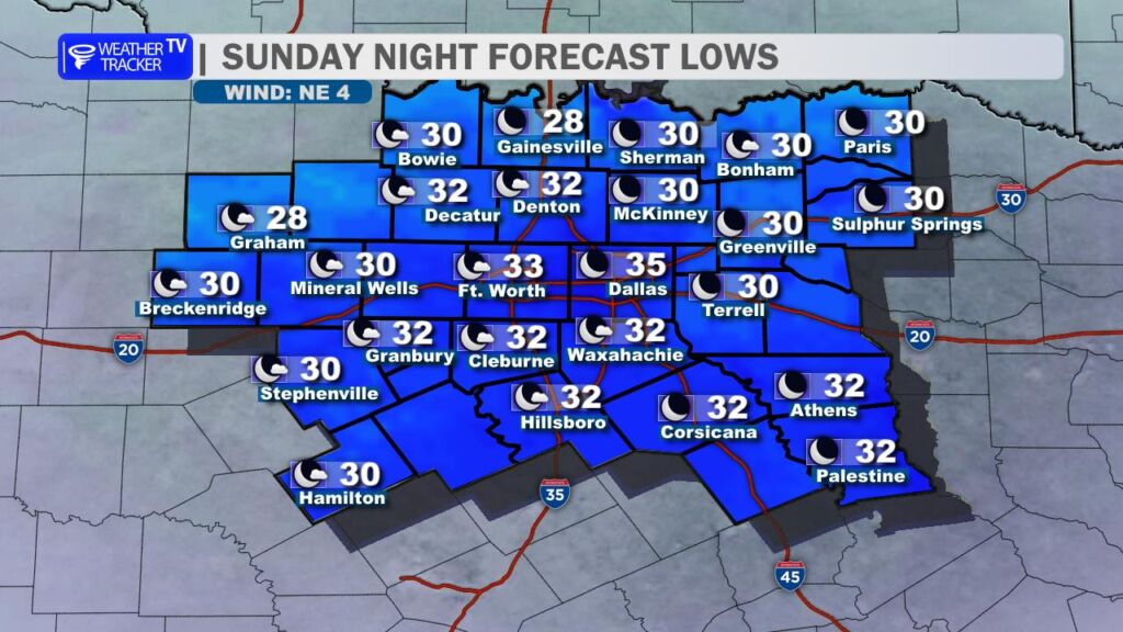
Another cold night is ahead tonight. Clear skies and light winds will allow temperatures to drop back into the 30s, and we could see another light freeze in some locations – especially in outlying and rural areas. If you’ve already started early spring planting, you may want to take precautions.
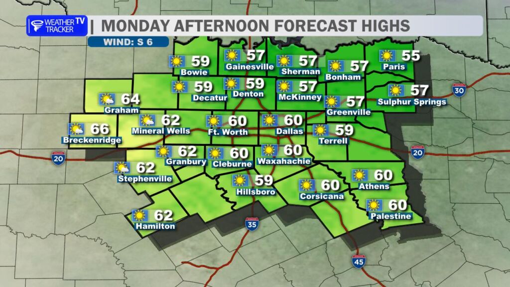
Monday looks very similar as we kick off the new work week. Expect abundant sunshine once again, with highs ranging from the upper 50s to lower 60s. Winds will gradually shift around to the south by late in the day – and that’s the signal that a warming trend is about to take hold.
By midweek, temperatures rebound in a big way. Highs climb back into the 70s Tuesday and surge into the 80s by Wednesday across much of North Texas. It will feel much more like spring, and the forecast currently stays dry through the next 7 to 10 days.
Enjoy the sunshine today – and get ready for a big temperature swing as we head into the week ahead. -William
Here is a look at Actual Lows from around North Texas this morning.

Actual Lows from around the Dallas – Fort Worth Metroplex this morning.

Here’s a look at our Sunday planner for the DFW Metroplex.

We’re wrapping up the weekend on a bright but cool note across the Dallas–Fort Worth Metroplex.
Today brings plenty of sunshine with afternoon highs in the upper 50s around DFW, a bit cooler north and slightly warmer to the south. North winds at 5 to 10 mph will keep a crisp feel in the air, but overall it’s a quiet and pleasant February day.
Tonight, skies stay mostly clear and temperatures drop quickly after sunset. Lows will fall into the lower 30s across much of North Texas, with some upper 20s possible in the colder spots. It’ll be a cold start Monday morning, so you’ll want the heavier jacket early on.
Monday looks terrific: wall-to-wall sunshine with highs near 60 degrees and light easterly winds. The warming trend really kicks in Tuesday, with highs jumping into the 70s and breezy south winds gusting up to 30 mph by afternoon.
After the chilly mornings, we’re headed for a spring preview by midweek with 80s returning.
Stay with William Cole & Weather Tracker TV.
Let’s stay safe together.
Today
Today – Precipitation
Tonight

Tomorrow

Here’s a look at our Sunday morning commute in the DFW Metroplex.
