
Here’s a look at Live Temperatures across North Texas, MesoScan Radar and the Updated Forecast Map.
DFW THIS AFTERNOON Sunny, warmer with highs in the lower 70s. South winds 15 to 20 mph with wind gusts up to 35 mph are possible. -William


Here’s a look at Live Temperatures across North Texas, MesoScan Radar and the Updated Forecast Map.
DFW THIS AFTERNOON Sunny, warmer with highs in the lower 70s. South winds 15 to 20 mph with wind gusts up to 35 mph are possible. -William
Good Tuesday Morning, North Texas!
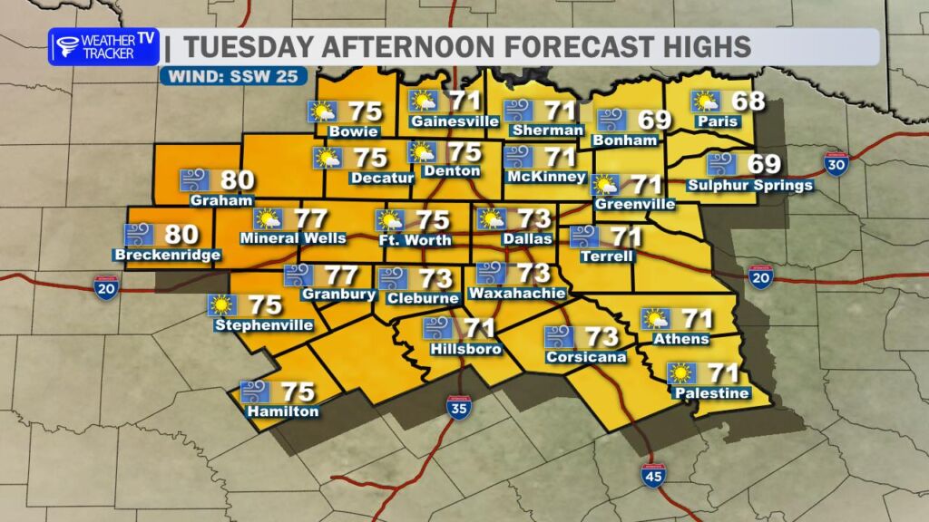
Get ready for a warm and windy day across the region. Sunshine will dominate the sky this afternoon, helping temperatures climb into the 70s for most communities. Out west in the Big Country, a few spots could even flirt with the low 80s.
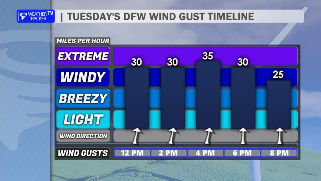
The bigger story today will be the wind. A strong southwest breeze will increase through the late morning and afternoon, with gusts frequently topping 35 mph and possibly pushing closer to 40 mph at times before sunset.
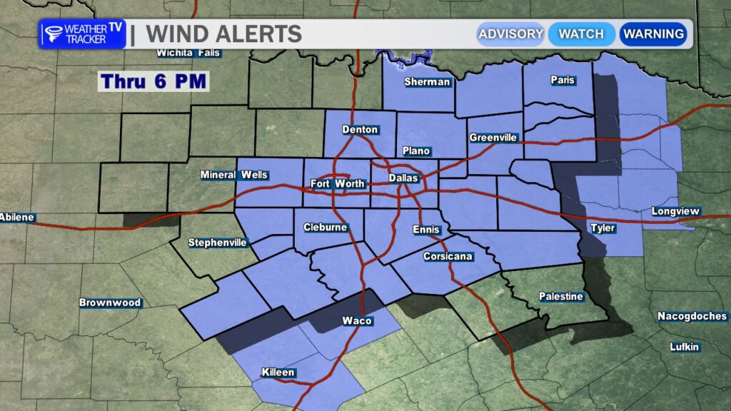
Because of those gusty conditions, a Wind Advisory remains in effect until 6 PM for much of North Texas. Loose outdoor items may be blown around, and high-profile vehicles could have difficulty on east-west roadways.
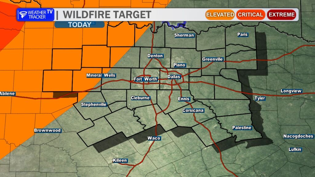
The combination of warm temperatures, strong southwest winds, and dropping humidity levels will also elevate fire danger across the area. Any outdoor burning is strongly discouraged today. Even small sparks – from equipment, welding, or dragging trailer chains – could quickly spread under these conditions.
Looking Ahead
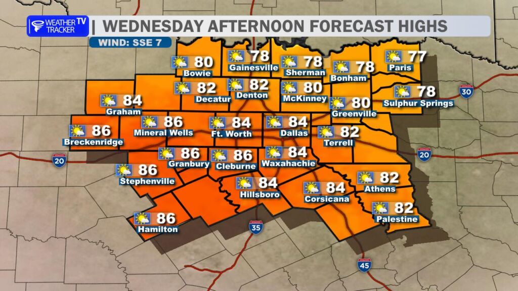
The warming trend continues into Wednesday. Winds ease up and shift more southeasterly, but temperatures climb even higher – with afternoon highs pushing into the 80s area-wide.
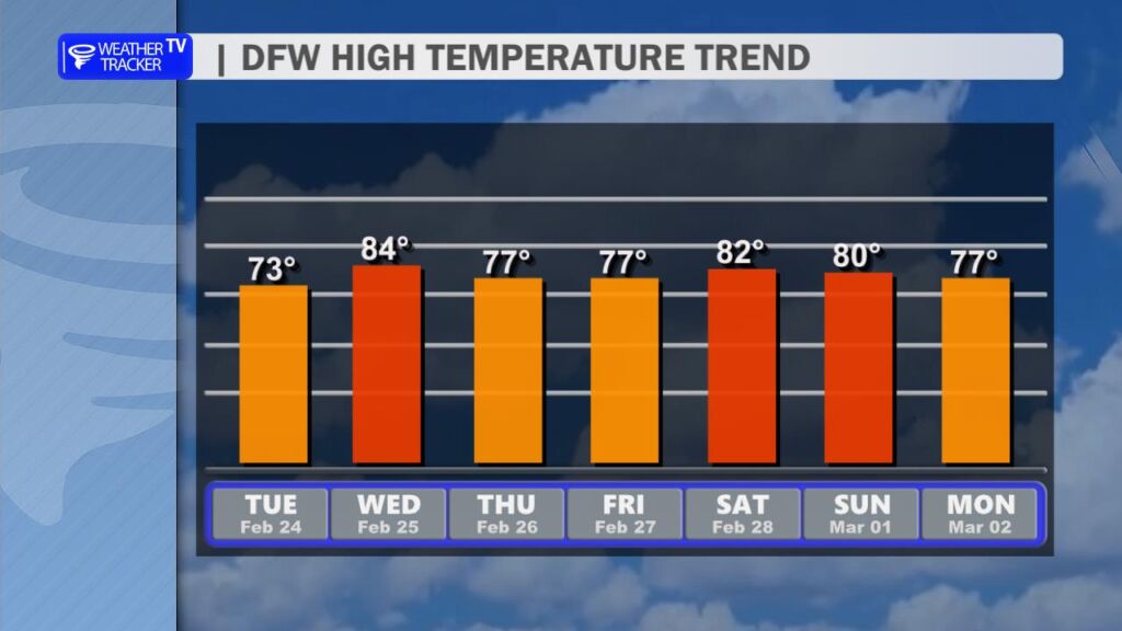
Warm conditions hold into the end of the week and through the weekend, with highs generally in the 70s to near 80 by Saturday. The overall pattern remains dry for at least the next seven days.
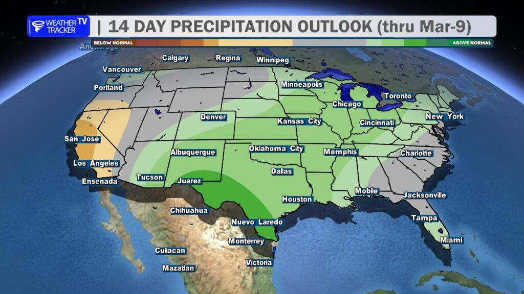
However, there are early signals that the weather pattern may become more active as we head into the first week of March. It’s too early for specifics, but rain chances could begin to return as we transition into a more unsettled setup.
We’ll keep watching it closely. -William
Here is a look at Actual Lows from around North Texas this morning.

Actual Lows from around the Dallas – Fort Worth Metroplex this morning.

Here’s a look at our Tuesday planner for the DFW Metroplex.

A Wind Advisory goes into effect at noon today across the Dallas–Fort Worth Metroplex and runs through 6 PM. Expect plenty of sunshine and a big warm-up, with highs climbing into the low to mid 70s. The main story will be the strong south wind. Sustained winds between 15 and 25 mph will develop this afternoon, with gusts up to 35 mph at times. That will make for difficult driving on east-west roads and could blow around unsecured outdoor items.
Tonight stays mostly clear and noticeably milder. Lows will only fall into the mid 50s with a continued south breeze, especially during the evening hours.
Tomorrow looks even warmer. Under mostly sunny skies, highs surge into the lower 80s with a lighter south wind by afternoon. A weak front arrives Thursday, bringing slightly cooler but still comfortable conditions heading into the end of the week.
Secure loose outdoor items today and use caution if traveling in high-profile vehicles due to strong crosswinds.
Stay with William Cole & Weather Tracker TV.
Let’s stay safe together.
Today
Today – Precipitation

Tonight

Tomorrow

Here’s a look at our Tuesday morning commute in the DFW Metroplex.

A Wind Advisory is in effect for North Texas today as strong south winds increase through the afternoon. Gusty conditions could make travel difficult and blow around unsecured items.

**Timing:**
– Noon to 6 PM today
**What to Expect:**
– South winds 20 to 25 mph
– Gusts up to 35 mph
**Potential Impacts:**
– Unsecured outdoor items may be blown around
– Difficult driving conditions, especially for high-profile vehicles
– Small tree limbs could break and cause minor damage
– Boating conditions on area lakes may be hazardous
**What to Do Now:**
– Secure trash cans, lawn furniture, and other lightweight outdoor items
– Use extra caution if driving, especially in trucks, vans, and SUVs
– Boaters should use extra caution on area lakes
Stay with William Cole and Weather Tracker TV.
Let’s stay safe together.
 A special wildfire danger statement has been issued by the National Weather Service in Fort Worth for Tuesday February 24:
ELEVATED FIRE THREAT NEAR AND NORTH OF INTERSTATE 20 TODAY.
Here’s a look at our Monday late evening planner for the DFW Metroplex.

Here is a look at Actual Highs from around North Texas today.

Actual Highs from around the Dallas – Fort Worth Metroplex today.

Today’s complete DFW Almanac.
