
A special wildfire danger statement has been issued by the National Weather Service in Fort Worth for Saturday February 2:
ELEVATED FIRE THREAT SATURDAY AFTERNOON ALONG AND WEST OF A LINE FROM JACKSBORO TO MINERAL WELLS TO COMANCHE.

A special wildfire danger statement has been issued by the National Weather Service in Fort Worth for Saturday February 2:
ELEVATED FIRE THREAT SATURDAY AFTERNOON ALONG AND WEST OF A LINE FROM JACKSBORO TO MINERAL WELLS TO COMANCHE.
Here’s a look at our Friday late evening planner for the DFW Metroplex.

Here is a look at Actual Highs from around North Texas today.

Actual Highs from around the Dallas – Fort Worth Metroplex today.

Today’s complete DFW Almanac.

Here’s a look at the Friday evening planner for the DFW Metroplex.

We’ll stay quiet and mild across the Metroplex tonight. Skies will remain mostly clear this evening, with just a slight chance of a brief shower after midnight. Most of us will stay dry. Overnight lows will settle into the mid to upper 50s with a light southeast breeze.
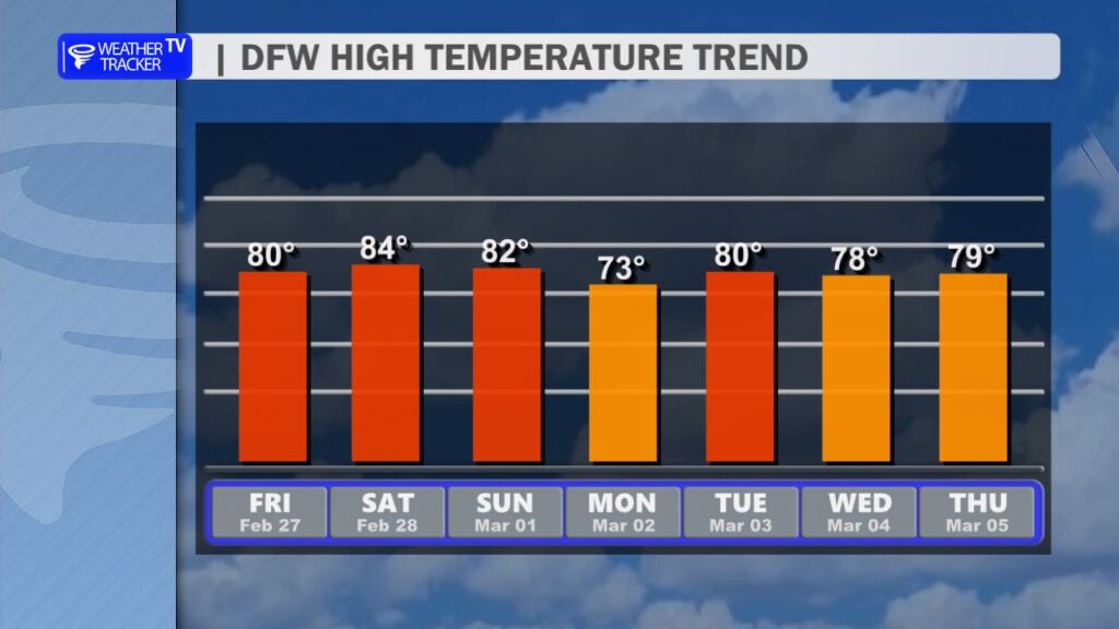
Saturday looks beautiful and warm. Expect plenty of sunshine with afternoon highs climbing into the lower to mid 80s across Dallas–Fort Worth. A south wind around 10 to 15 mph will develop by afternoon, adding a bit of a spring feel to the day. Sunday stays sunny and warm as well, with highs again in the lower 80s and breezy south winds.
Early next week remains mild with highs in the upper 70s to lower 80s. Clouds increase Tuesday, and rain chances return late Tuesday night. Showers and a few thunderstorms become more likely Wednesday into Wednesday night, with several rounds of rain possible before gradual clearing Thursday.
Plan for wet roads and occasional thunderstorms midweek, especially Wednesday afternoon and evening.
Stay with William Cole & Weather Tracker TV.
Let’s stay safe together.
Tonight

Tonight – Precipitation

Tomorrow

Tomorrow – Precipitation

Here’s a look at our Friday evening commute in the DFW Metroplex.


Here’s a look at Live Temperatures across North Texas, MesoScan Radar and the Updated Forecast Map.
DFW THIS AFTERNOON Sunny. Highs around 80. East winds around 5 mph. -William

Happy Friday, North Texas!
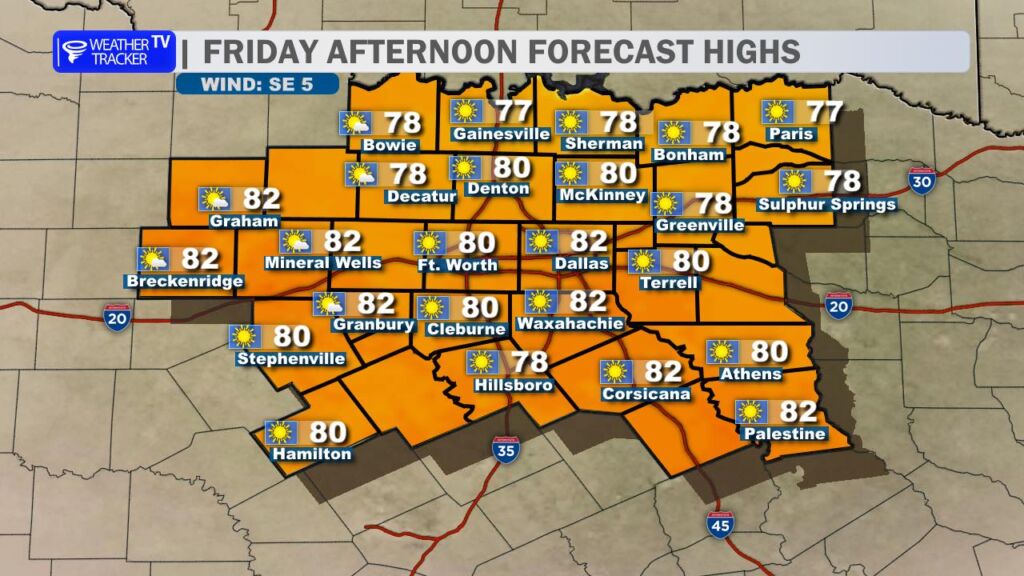
We’re wrapping up the workweek on a quiet and very warm note. Expect mostly sunny skies this afternoon with temperatures climbing to around 80 degrees for most locations. That’s well above average for late February. Winds will be light out of the southeast, making for a very pleasant day overall.

If you have Friday evening plans – dinner on the patio, or just getting outside – the weather will cooperate. Temperatures will ease back through the 60s through about 10 PM with fair skies and light winds. It should be a comfortable and enjoyable evening across the area.
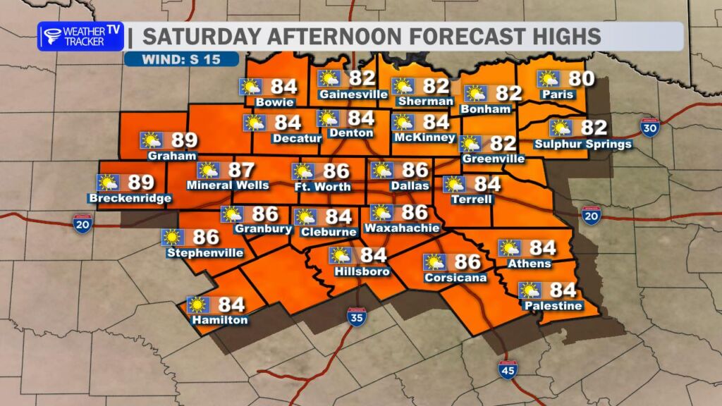
Saturday turns even warmer – and for some spots, downright hot for this time of year. Highs will surge well into the 80s across North Texas, and a few communities in our western counties and the Big Country could approach 90 degrees. We may start the day with some morning cloud cover, but sunshine should take over by afternoon. A steady south breeze at 10 to 15 mph will add to that early spring feel.
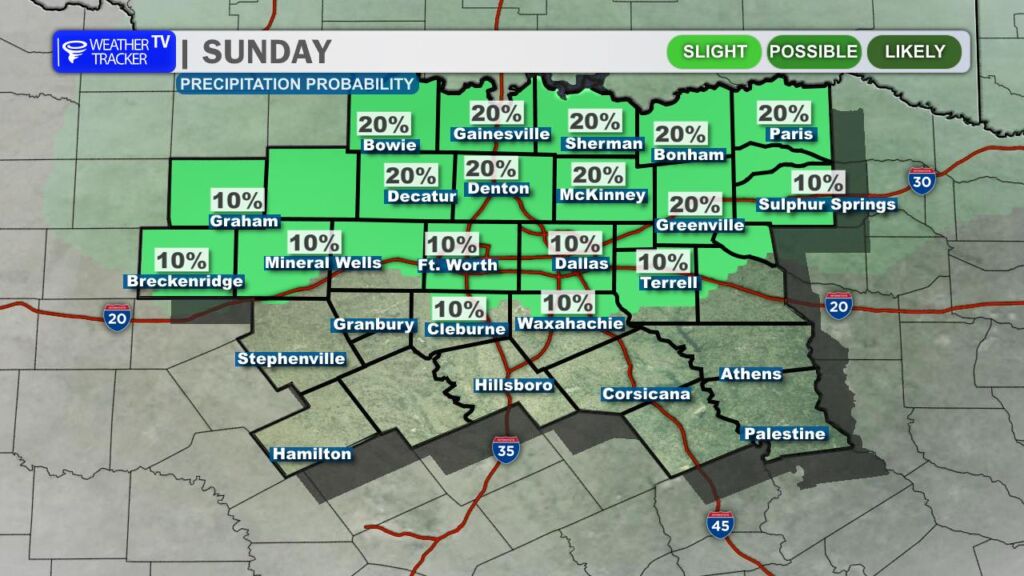
As we head into Sunday, we’ll keep an eye on a weak disturbance passing to our north. A few showers or thunderstorms developing in Oklahoma could drift toward the Red River. Rain chances locally remain low – only about 10 to 20 percent – and most of us will stay dry. Temperatures will remain above normal with highs in the 70s and 80s.
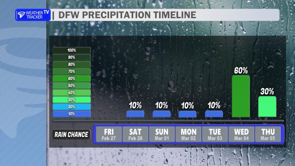
Looking ahead to next week, the overall pattern begins to shift. Better rain chances arrive by midweek and could linger into the following weekend. Several rounds of showers and thunderstorms appear possible. While it’s still early, there are some indications that a few stronger storms could develop depending on how the setup evolves. We’ll continue to fine-tune the timing and severity potential over the coming days.
In the meantime, enjoy the stretch of warm, quiet weather – it certainly feels more like late spring than late winter across North Texas! -William
Here is a look at Actual Lows from around North Texas this morning.

Actual Lows from around the Dallas – Fort Worth Metroplex this morning.

Here’s a look at our Friday planner for the DFW Metroplex.
