Widespread rain is on tap across the Dallas–Fort Worth Metroplex today, and most of us will stay wet from morning through the afternoon. Periods of showers will be steady, with a few thunderstorms developing at times. Some neighborhoods, especially east of DFW, could see pockets of heavier rainfall later today. Highs will stay cooler, generally in the upper 60s to near 70 with a light south breeze.
Rain chances remain elevated tonight. Showers and a few rumbles of thunder will linger through the evening before gradually tapering after midnight. Skies stay mostly cloudy with lows settling into the mid 50s as winds shift to the northwest.
By Sunday, we turn the corner. Clouds will thin through the morning with sunshine returning in the afternoon. It’ll be cooler and breezy, with highs in the mid to upper 60s and a north wind at 10 to 15 mph.
Plan for wet roads and reduced visibility at times today, especially during heavier downpours.
Stay with William Cole & Weather Tracker TV.
Let’s stay safe together.
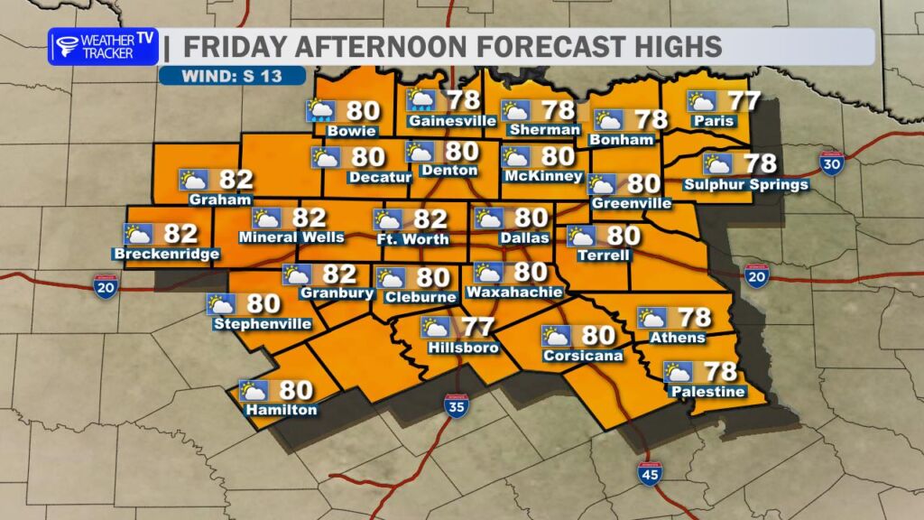
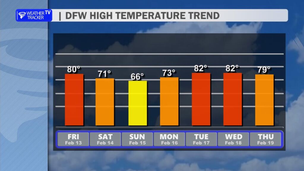
A warm finish to Friday with highs near 80 across the Dallas–Fort Worth Metroplex, but changes are on the way.
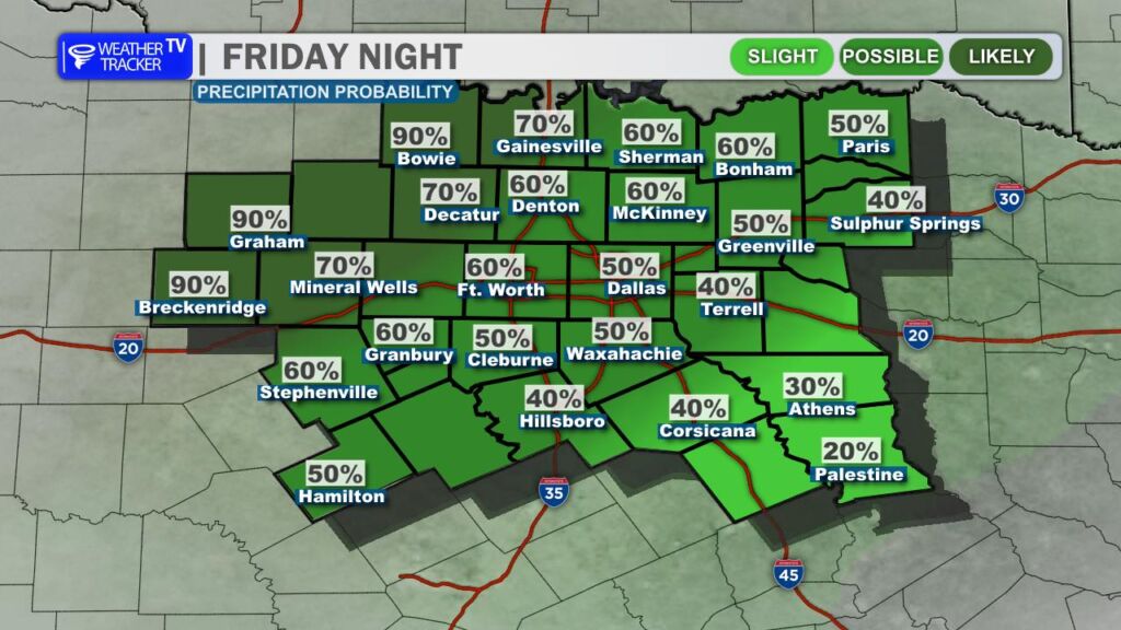
Tonight, clouds thicken with a 50 percent chance of showers developing after midnight as temperatures remain mild in the lower 60s.
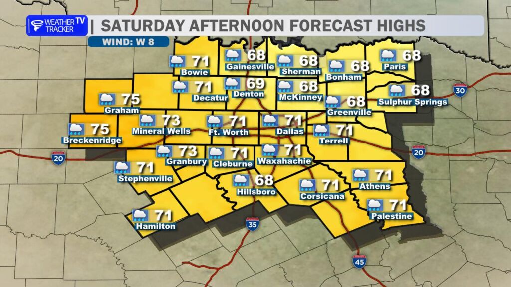
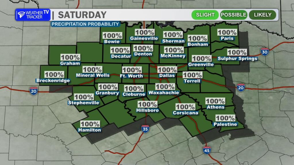
Tomorrow, expect a wet start to the weekend. Showers are likely in the morning with periods of rain continuing into the afternoon, along with a few thunderstorms. Rain chances are near 100 percent, and some spots could see locally heavy rainfall before cooler air arrives with highs only in the upper 60s.
Showers taper Saturday night, and we’ll turn drier and cooler Sunday with highs in the mid to upper 60s under clearing skies.
Stay with William Cole & Weather Tracker TV. Let’s stay safe together.
We’re wrapping up the workweek on a warm and increasingly humid note. Clouds will steadily build through the day, and that extra moisture in the air will be noticeable by afternoon. High temperatures climb to around 80 degrees area-wide – running well above seasonal averages for mid February.
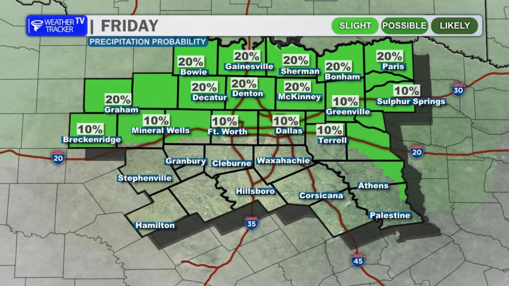
A stray shower can’t be ruled out this afternoon, but most locations will stay dry through daylight hours.
Rain chances ramp up tonight, especially across our western counties first. Scattered showers will begin developing and gradually expand eastward overnight as our next storm system approaches.
❤️ Valentine’s Day Forecast – Plan for Rain
Saturday looks unsettled from start to finish. Periods of showers are likely through the day, with coverage increasing during the afternoon and evening hours. That’s when we could also see a few thunderstorms develop.
If you have Valentine’s dinner plans – especially across the Dallas–Fort Worth Metroplex – plan for wet roads and allow a little extra travel time. The steadiest rain and embedded storms are most likely late afternoon through the evening.
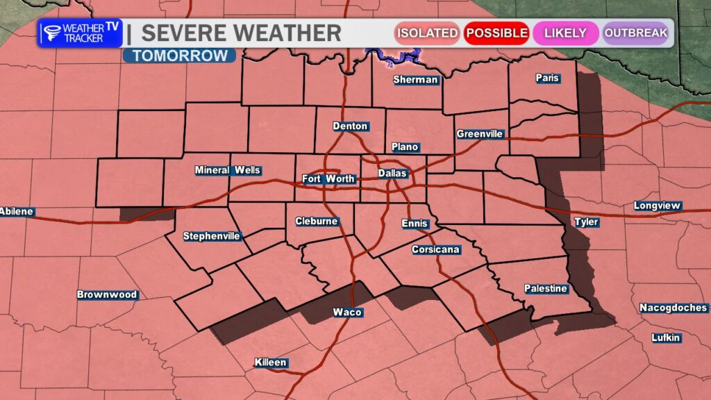
The good news: organized severe weather is not expected. However, it’s not out of the question that one or two storms could briefly become strong. The main concerns would be wind gusts up to 60 mph and possibly quarter-size hail. Widespread severe weather is not anticipated.
Rain should gradually taper off from west to east late Saturday night into early Sunday morning.
💧 Rainfall & Flooding Concerns
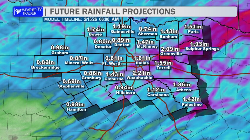
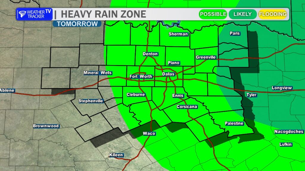
Rainfall totals continue to look beneficial. Current projections suggest a broad average of 1 to 1.5 inches across North Texas, with isolated higher amounts possible where heavier downpours occur.
At this time, widespread flooding concerns remain low. Of course, ponding on roadways is possible during heavier bursts of rain, so just use caution while driving.
🌤️ What’s Next?
A cold front sweeps through behind this system, bringing cooler air for Sunday. Afternoon highs will settle back into the 60s – still comfortable, but noticeably cooler compared to Saturday.
The cooldown won’t last long. Temperatures rebound quickly early next week, with highs surging back into the 80s by Tuesday. -William