Quiet Weather Today, Fire Danger Thursday

Good Wednesday Morning, North Texas!

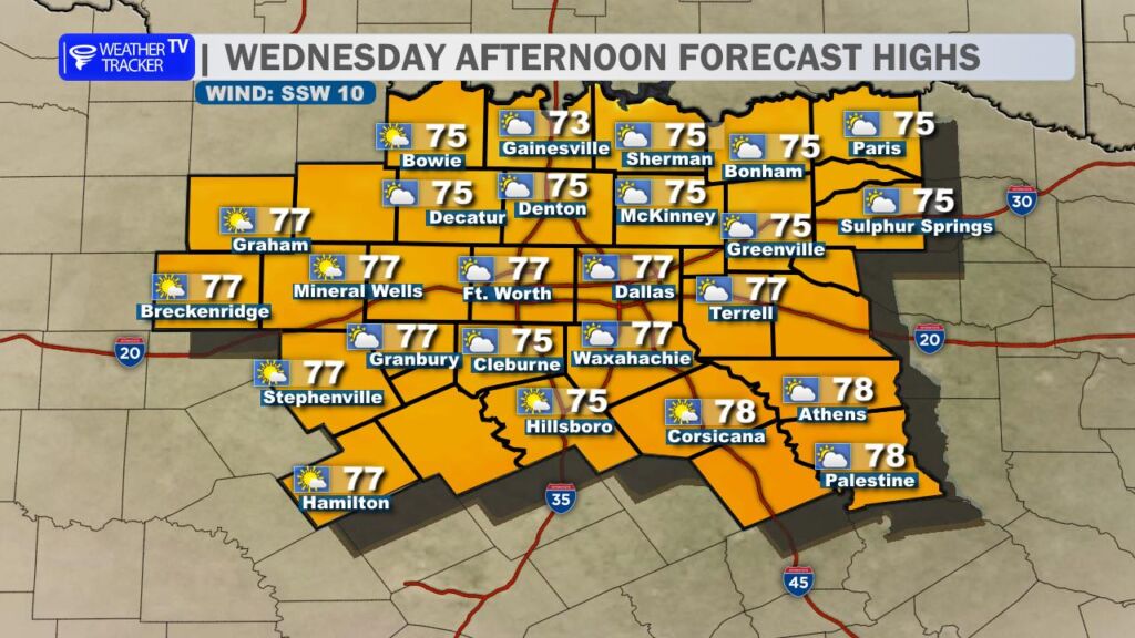
We’re in for another beautiful February day across the region. Morning clouds will gradually thin out, giving way to increasing sunshine this afternoon. High temperatures will climb into the 70s area-wide -well above average for this time of year. Winds remain light, making today the pick of the week to get outdoors. Whether you’re planning a walk along the Katy Trail, getting some yard work done, or taking Fido out for a neighborhood stroll, conditions will be just about perfect.

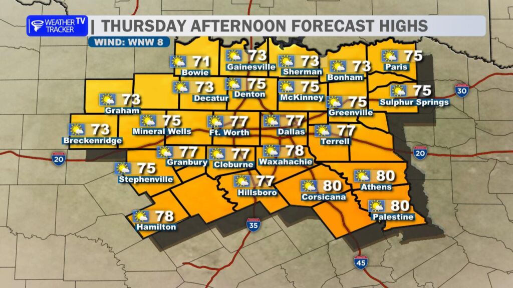
Changes arrive quickly on Thursday.

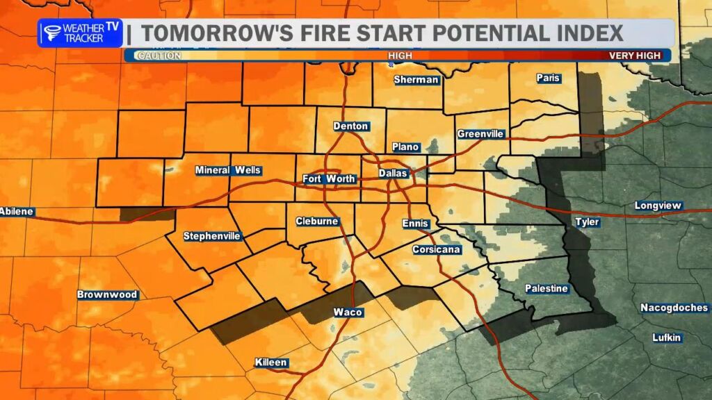
A windy cold front will sweep through during the day, shifting winds to the northwest and increasing gusts up to 30 mph at times. Despite the front, temperatures will still reach the 70s before gradually easing later in the day. The bigger story will be the combination of gusty winds, dropping humidity, and dry vegetation – a setup that elevates fire danger concerns across parts of North Texas.

A Fire Weather Watch has been posted for areas just northwest of the Dallas–Fort Worth Metroplex. Outdoor burning is strongly discouraged, and it’s important to avoid anything that could produce sparks – including equipment use in dry grass. Any fire that develops could spread rapidly under these conditions.

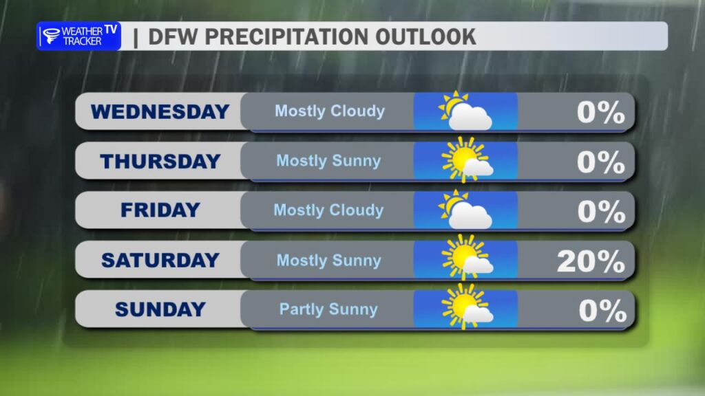
Looking ahead, another front slides through late Friday into Saturday. This system will nudge temperatures down a bit as we head into the weekend, bringing highs closer to seasonal norms. There is also a very slight chance of a few light showers late Friday into early Saturday, but rainfall coverage and amounts currently look minimal.

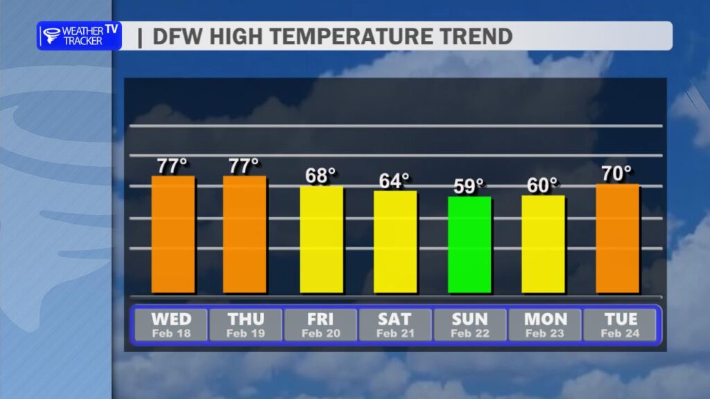
By early next week, temperatures rebound once again, with highs returning to the 70s.

Enjoy today’s calm and comfortable weather — it’s the quiet before a breezy and more fire-sensitive stretch tomorrow. -William

DFW Forecast Today

We’re in for another warm and quiet February day across the Dallas–Fort Worth Metroplex.

Today will feature a mix of sun and clouds with afternoon highs climbing into the mid 70s. Winds stay light, turning out of the southwest later today. It’s a comfortable setup overall and a great day to be outside.

Tonight remains mild and mostly clear. Lows will only dip into the upper 50s and lower 60s with a light south breeze continuing overnight.

Tomorrow looks even sunnier with highs again reaching the mid 70s. West winds increase to around 10 to 15 mph during the afternoon, and that breeze combined with dry air will elevate fire weather concerns west and northwest of DFW. While the highest risk stays in North Texas counties under a Fire Weather Watch, it’s still a good idea to avoid outdoor burning across the region.

A cooler air mass arrives Thursday night, setting us up for a refreshing end to the week.

Stay with William Cole & Weather Tracker TV.
Let’s stay safe together.

Today

North Texas Today Forecast

Today – Precipitation

North Texas Today Precipitation Forecast

Tonight

North Texas Tonight Forecast

Tomorrow

North Texas Tomorrow Forecast

2:16 AM Fire Weather Watch

Critical fire danger is possible across parts of North Texas from late Thursday morning through Thursday evening due to strong winds and very low humidity. A Fire Weather Watch has been issued for Montague, Cooke, Grayson, Young, Jack, and Wise counties.

DFW Warning Map

**Timing:**
– Late Thursday morning through Thursday evening

**What to Expect:**
– West-northwest winds 15 to 20 mph
– Wind gusts up to 35 mph
– Relative humidity as low as 10 percent

**Potential Impacts:**
– Fires could spread rapidly if they start
– Outdoor burning is not advised
– Fuel conditions: 70th–89th percentile (4 out of 5)
– Weather conditions: Near Critical (2 out of 5)
– Overall fire environment: 6 out of 10

**What to Do Now:**
– Avoid any outdoor burning
– Listen for updated forecasts and possible Red Flag Warnings

Stay with William Cole and Weather Tracker TV.
Let’s stay safe together.

DFW Forecast Tonight

North Texas stays quiet and mild tonight. Expect partly cloudy skies across the Metroplex with lows settling into the upper 50s. Winds will ease a bit overnight, shifting from the south to southwest at 5 to 10 mph by daybreak.

Wednesday looks even warmer. We’ll see a mix of sun and clouds with afternoon highs pushing the upper 70s across Dallas–Fort Worth. Winds stay light, generally out of the southwest around 5 to 10 mph. Wednesday night remains mild with lows near 60 and a partly cloudy sky.

Thursday brings plenty of sunshine and another warm afternoon in the upper 70s before a cooler air mass slips in Thursday night. Lows will drop into the 40s, setting up a noticeably cooler end to the week. Highs fall back into the mid to upper 60s Friday. A weak system may bring a slight chance of showers late Friday night into Saturday morning, but rainfall looks spotty and light. Behind it, colder mornings return this weekend with lows in the 30s and highs in the 50s.

Stay with William Cole & Weather Tracker TV.
Let’s stay safe together.

Tonight

North Texas Today Forecast

Tonight – Precipitation

North Texas Today Precipitation Forecast

Tomorrow

North Texas Tonight Forecast

Tomorrow – Precipitation

North Texas Tomorrow Forecast