Here’s a look at our Friday morning commute in the DFW Metroplex.

Here’s a look at our Friday morning commute in the DFW Metroplex.
Here’s a look at our Thursday late evening planner for the DFW Metroplex.

Here is a look at Actual Highs from around North Texas today.

Actual Highs from around the Dallas – Fort Worth Metroplex today.

Today’s complete DFW Almanac.

Here’s a look at the Thursday evening planner for the DFW Metroplex.

After a beautiful spring preview this afternoon, a cooldown is settling into North Texas tonight. Skies stay mostly clear, but temperatures will drop quickly after sunset. Expect lows in the lower 40s across Dallas–Fort Worth by early Friday morning with a light north breeze turning northeast overnight.
Friday brings plenty of sunshine, but it will feel noticeably cooler. Afternoon highs top out in the mid to upper 60s with a light easterly wind. Friday night will be quiet with partly cloudy skies and lows again in the 40s.
The weekend stays dry, but another reinforcing shot of cooler air arrives Saturday. Highs will be in the 60s with a gusty north wind developing during the afternoon. By Sunday morning, many spots will wake up to temperatures in the 30s. Sunshine continues Sunday and Monday with cool afternoons in the upper 50s to lower 60s.
A warming trend kicks in Tuesday, and by Wednesday we’ll be talking about 80s returning to North Texas.
Stay with William Cole & Weather Tracker TV.
Let’s stay safe together.
Tonight

Tonight – Precipitation

Tomorrow

Tomorrow – Precipitation

Here’s a look at our Thursday evening commute in the DFW Metroplex.


Here’s a look at Live Temperatures across North Texas, MesoScan Radar and the Updated Forecast Map.
DFW THIS AFTERNOON Sunny. Highs in the upper 70s. West winds 5 to 10 mph. -William

Happy Thursday, North Texas!
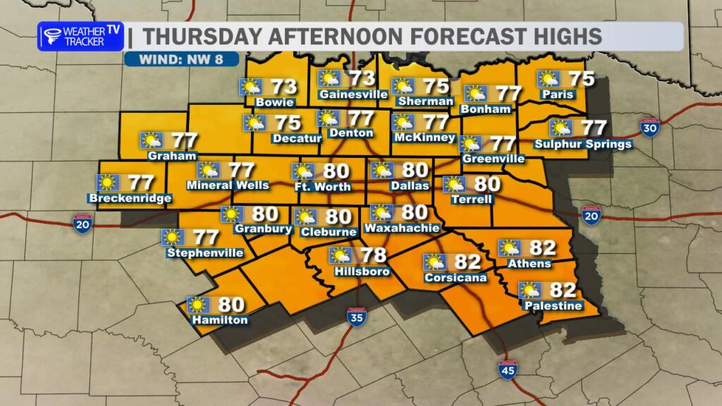
We’re headed for another unseasonably warm and breezy afternoon across the region. High temperatures will climb well into the 70s areawide, with a few southern counties flirting with the lower 80s. Skies will feature a mix of sun and passing clouds through the day.
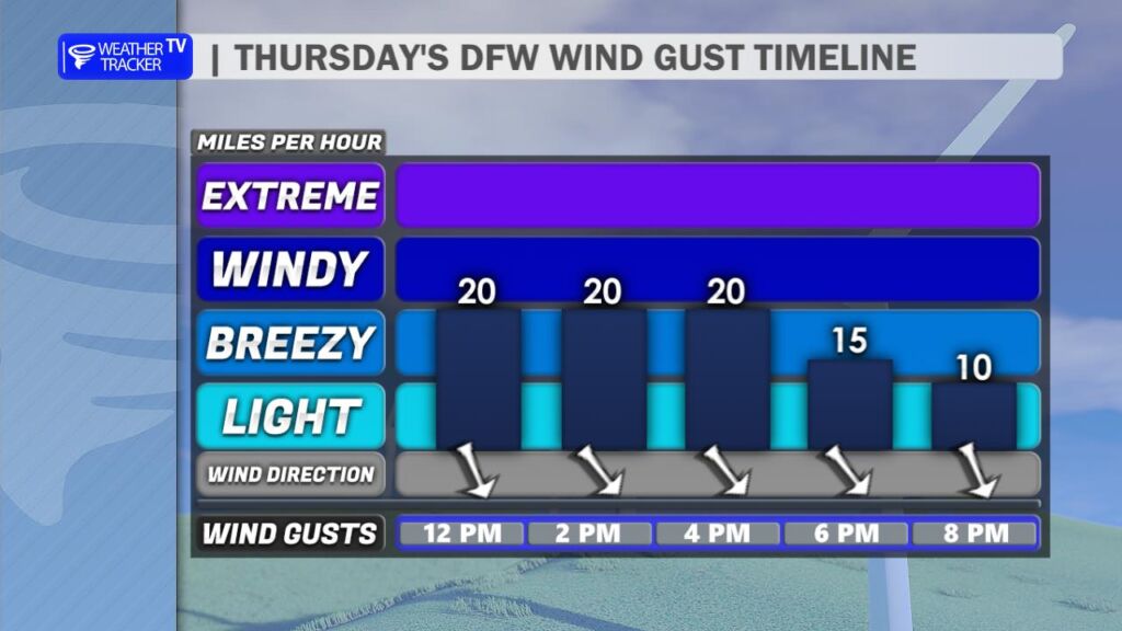
A cold front will sweep through the area this afternoon. As it moves across North Texas, winds will shift from the southwest to the west and eventually northwest. Gusts could reach up to 30 mph at times, especially during the mid to late afternoon hours.
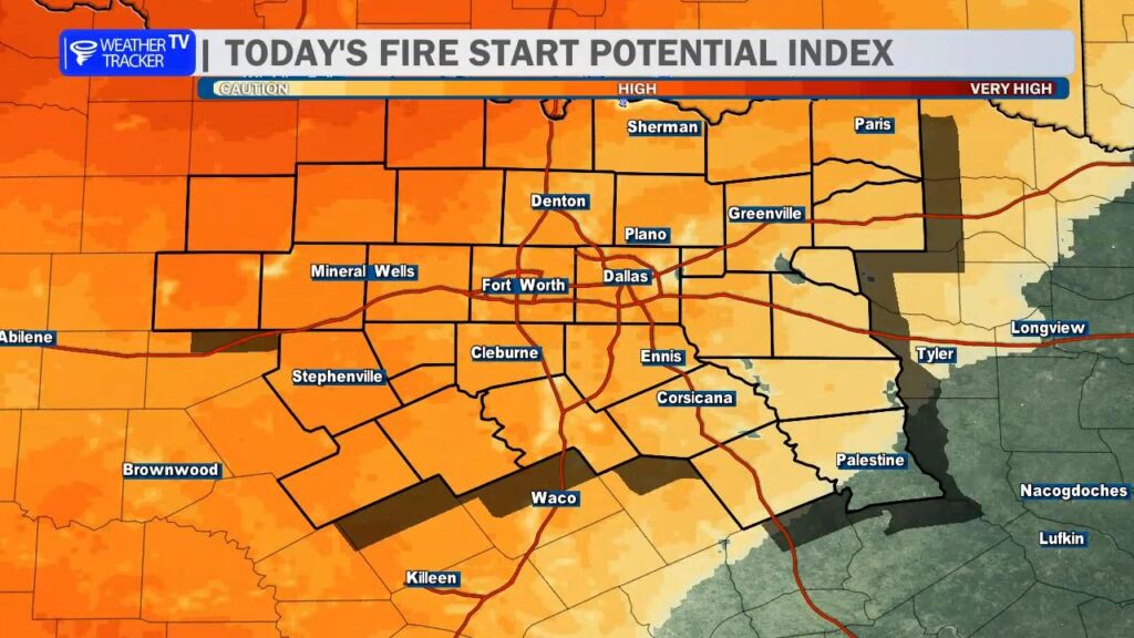
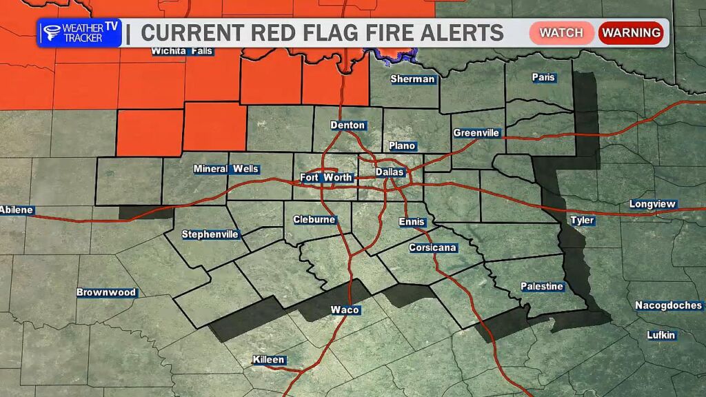
That wind shift combined with warm temperatures and falling humidity levels will significantly elevate the fire danger today. The greatest concern will be just northwest of the Dallas–Fort Worth Metroplex, where a Red Flag Warning is in effect. Under these conditions, any fire that starts could spread rapidly.
Fire Safety Reminders:
Fire danger will remain elevated through sunset before gradually easing this evening as winds begin to relax.
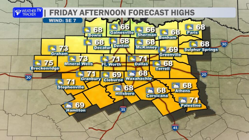
By Friday, cooler air settles in behind today’s front. Afternoon highs will scale back into the 60s with a few lower 70s. Northwest winds will be lighter, and we’ll keep a mix of sun and clouds in place.
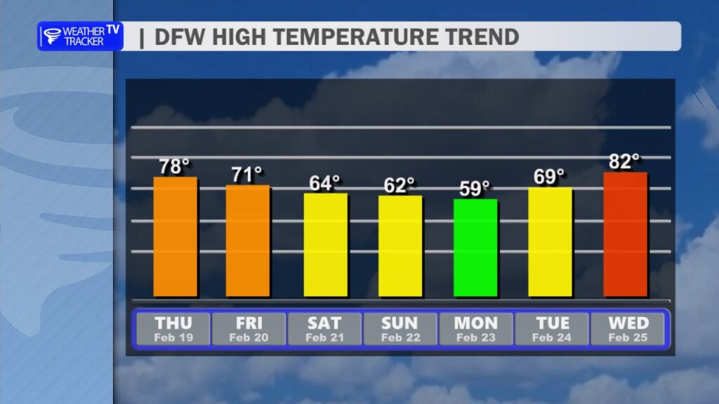
Another reinforcing cold front arrives Saturday, keeping temperatures on the cool side through the remainder of the weekend and into early next week. Highs will stay below today’s levels, but no major cold blast is expected.
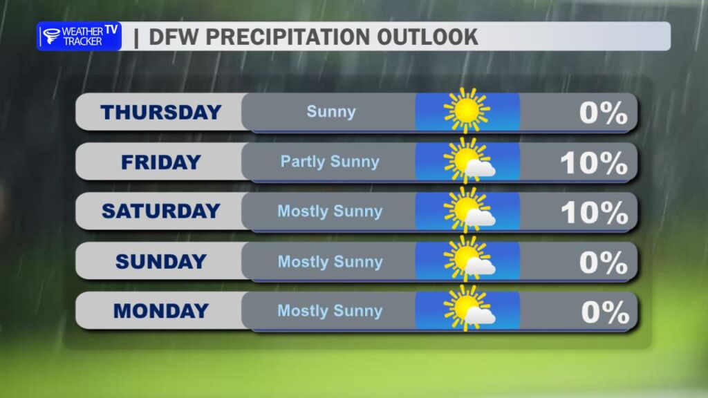
Rain chances remain very limited. Outside of a slim 10% chance of a brief, isolated shower with Saturday’s front, the forecast stays dry. Looking ahead, temperatures rebound nicely by midweek next week, with highs returning to the 70s.
Stay weather aware – and especially fire aware – today, North Texas. -William
Here is a look at Actual Lows from around North Texas this morning.

Actual Lows from around the Dallas – Fort Worth Metroplex this morning.

Here’s a look at our Thursday planner for the DFW Metroplex.
