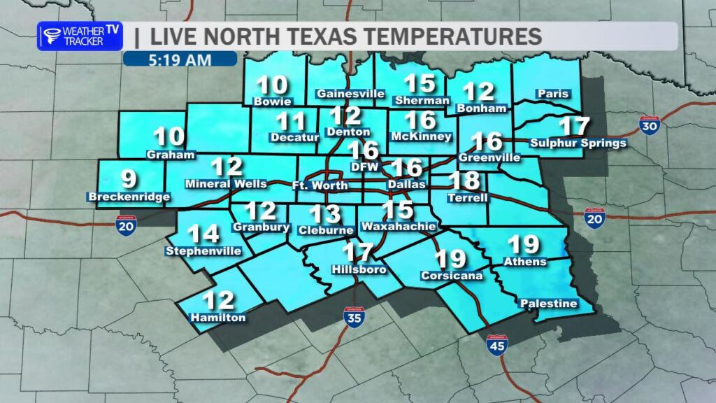
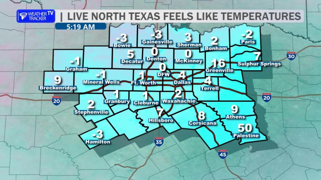
5:15 AM – Good Monday morning. It’s a bitterly cold start, with temperatures in the teens and wind chills near zero across North Texas. Roadways remain slick and hazardous across the Metroplex. Stay home and stay warm if you can.
5:15 AM – Good Monday morning. It’s a bitterly cold start, with temperatures in the teens and wind chills near zero across North Texas. Roadways remain slick and hazardous across the Metroplex. Stay home and stay warm if you can.

Here’s a look at MesoScan Radar and Live Temperatures across North Texas.
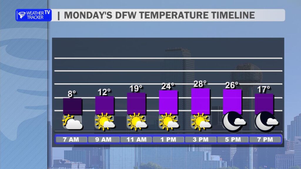
DFW TODAY Sunny. Highs in the upper 20s. Northwest winds 5 to 10 mph.

Here’s a look at our Sunday late evening planner for the DFW Metroplex.

Here is a look at Actual Highs from around North Texas today.

Actual Highs from around the Dallas – Fort Worth Metroplex today.

Today’s complete DFW Almanac.

Here’s a look at the Sunday evening planner for the DFW Metroplex.


DFW TONIGHT Mostly cloudy in the evening, then becoming partly cloudy. Occasional snow in the evening. No snow accumulation expected. Cold with lows around 10 above. North winds 5 to 10 mph. Chance of snow 20 percent. -William

Here’s a look at our Sunday evening commute in the DFW Metroplex.

Here’s a look at Live Temperatures across North Texas, MesoScan Radar and the Updated Forecast Map.
DFW THIS AFTERNOON Mostly cloudy with a 40 percent chance of snow. No snow accumulation expected. Cold with highs in the lower 20s. Northwest winds 10 to 15 mph. Wind chill values as low as 4 above. -William

Good Sunday morning, North Texas!
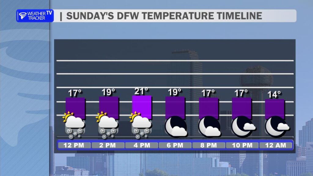
The winter storm continues across the region. While precipitation is finally tapering off today, the bigger story now becomes the bitterly cold temperatures and dangerous wind chills.
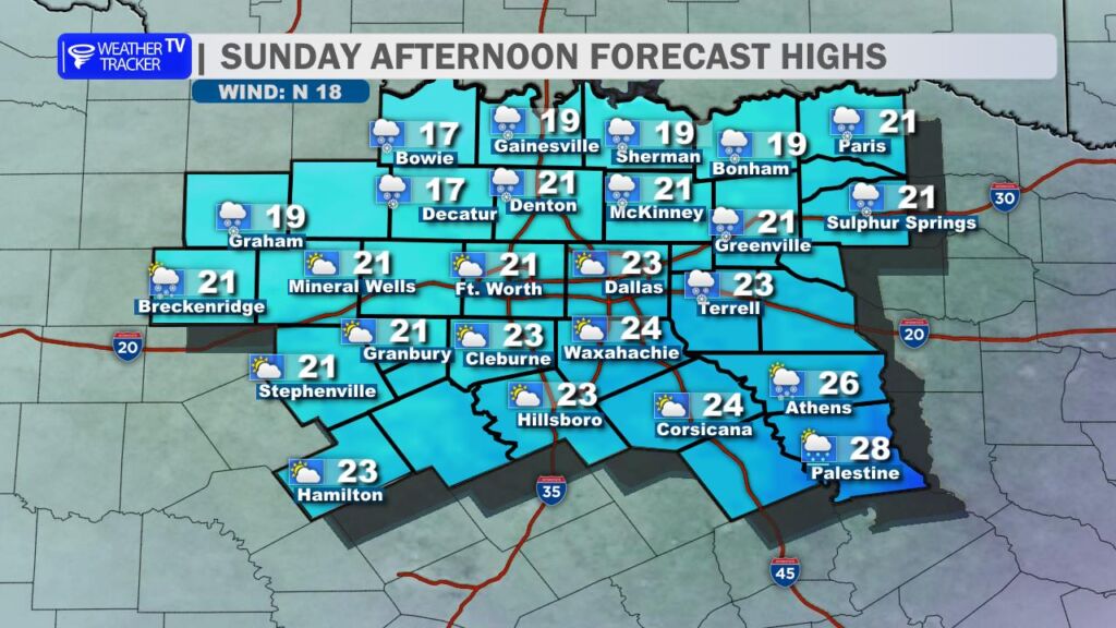
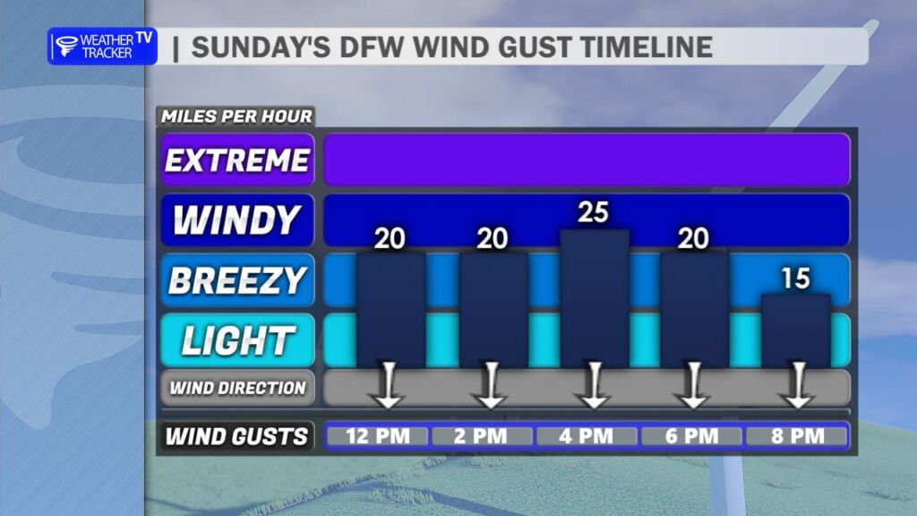
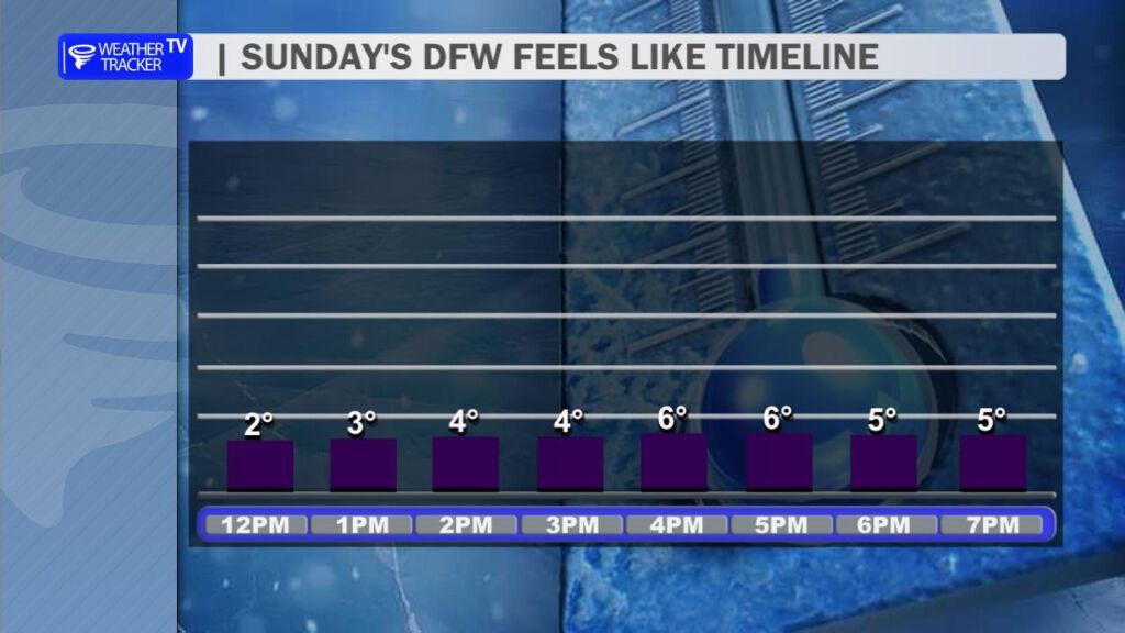
This afternoon, temperatures will essentially flatline in the teens and 20s area-wide. Gusty north winds will keep wind chill values dangerously cold, dropping into the single digits. Roadways across the Metroplex remain sleet-covered and are reported to be slick and hazardous. If possible, stay off the roads. With these temperatures and wind chills, it’s best to stay home and stay safe.
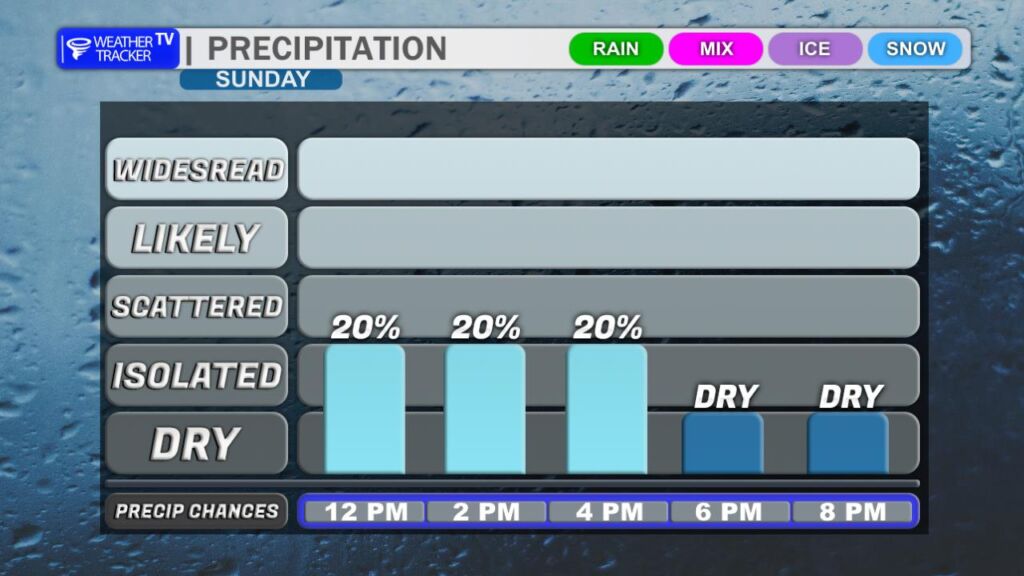
As the core of the upper-level storm system moves through later today, a brief burst of flurries is possible. No additional accumulation is expected.
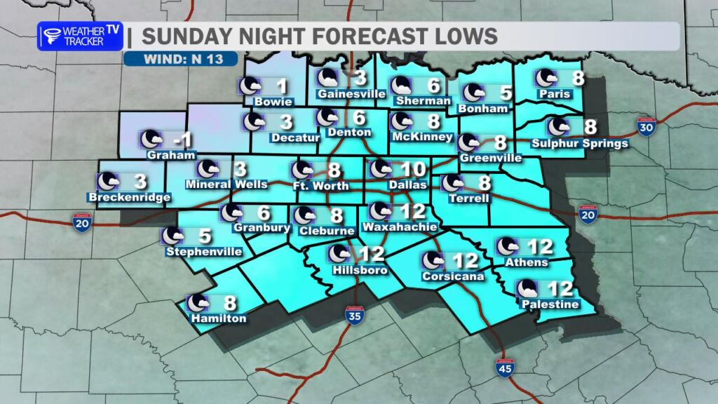
Tonight, we head into record-breaking cold. Low temperatures will fall to near zero northwest of DFW and around 8 to 10 degrees in the Metroplex. The record low at DFW is 12 degrees, and we are expected to break it. Be sure to drip faucets to help prevent pipes from freezing and bursting.
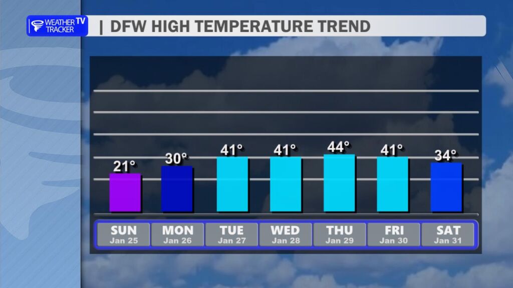
It will take until Tuesday afternoon – around 1 PM – for DFW to climb back above freezing. This remains a prolonged, multi-day stretch of subfreezing temperatures.
Here is a look at Actual Lows from around North Texas this morning.

Actual Lows from around the Dallas – Fort Worth Metroplex this morning.
