From William Cole: A Freezing Fog Advisory has been issued in the Weather Tracker TV DFW coverage area from 3:00 AM Wednesday until 11:00 AM Wednesday for Collin, Cooke, Dallas, Delta, Denton, Ellis, Erath, Fannin, Grayson, Hood, Hopkins, Hunt, Jack, Johnson, Kaufman, Lamar, Montague, Palo Pinto, Parker, Rains, Rockwall, Somervell, Stephens, Tarrant, Van Zandt, Wise & Young Counties in North Texas.
Visibility three miles or less in freezing fog.
Stay with William Cole and Weather Tracker TV Dallas – Fort Worth for continuing coverage, online, on our app and on TV. Let’s stay safe together.
From William Cole: A Freezing Fog Advisory has been issued in the Weather Tracker TV DFW coverage area from 3:00 AM Wednesday until 11:00 AM Wednesday for Bosque, Hamilton & Hill Counties in North Texas.
For the Cold Weather Advisory, very cold wind chills as low as 7 above zero expected. For the Freezing Fog Advisory, visibility of three miles or less in freezing fog.
Stay with William Cole and Weather Tracker TV Dallas – Fort Worth for continuing coverage, online, on our app and on TV. Let’s stay safe together.
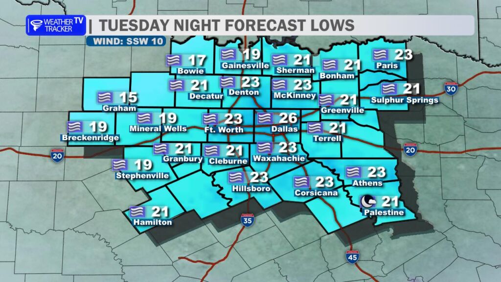
DFW TONIGHT Mostly cloudy. Patchy freezing fog after midnight. Cold with lows in the mid 20s. South winds around 5 mph, becoming west after midnight. -William
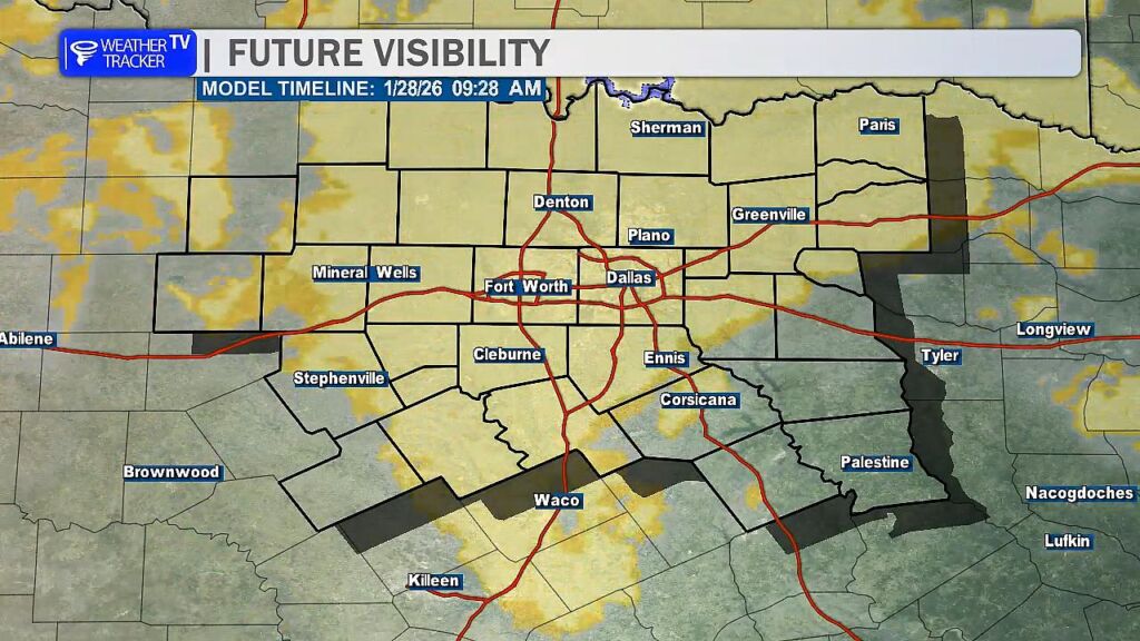
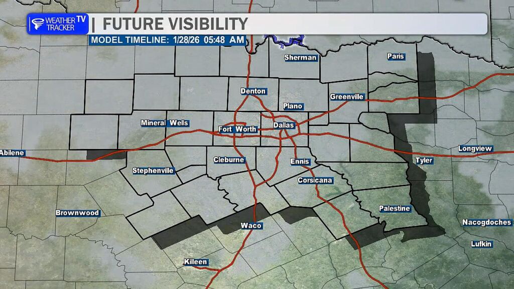
Widespread freezing fog likely overnight and tomorrow morning.
North Texas finally saw some meaningful improvement this afternoon as temperatures climbed into the 40s across many locations. That thaw helped quite a bit – we saw melting on area roadways and better travel conditions compared to the past couple of days. The sunshine and above freezing temperatures definitely worked in our favor.
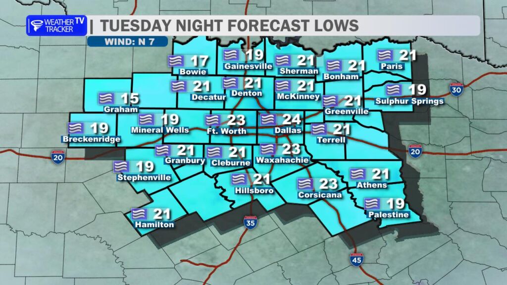
Overnight lows drop back into the teens and 20s.
However, we have one more winter weather hurdle to get through tonight and into Wednesday morning.
Widespread dense fog is expected to develop overnight as temperatures fall back into the teens and 20s. With readings dropping well below freezing, that fog will become freezing fog – and that’s where the concern ramps back up. Freezing fog can deposit a thin glaze of ice on elevated surfaces like bridges and overpasses, but it can also create slick spots on surface streets, especially in areas that still have lingering slush or compacted sleet.
In addition to icy spots, visibility may be significantly reduced at times – potentially dropping below one mile and even approaching near-zero in areas. That combination of low visibility and new ice development could make for an extremely treacherous Wednesday morning commute.
Now is the time to plan ahead. If you have flexibility to delay travel until later in the morning or closer to midday – when temperatures begin to rise and visibility improves – that would be a wise decision. Conditions should gradually improve once we get past mid-morning, but early travel could be hazardous.
If you have to be on the roads tonight or tomorrow morning – stay alert, allow extra time, and be prepared for rapidly changing conditions and visibility.
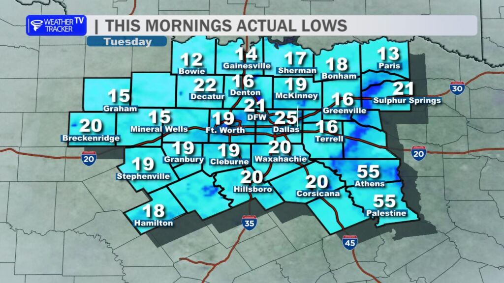
It’s another bitterly cold start across the region. Most communities woke up to temperatures in the teens and 20s, and officially at DFW Airport we dropped to 21 degrees right around sunrise.
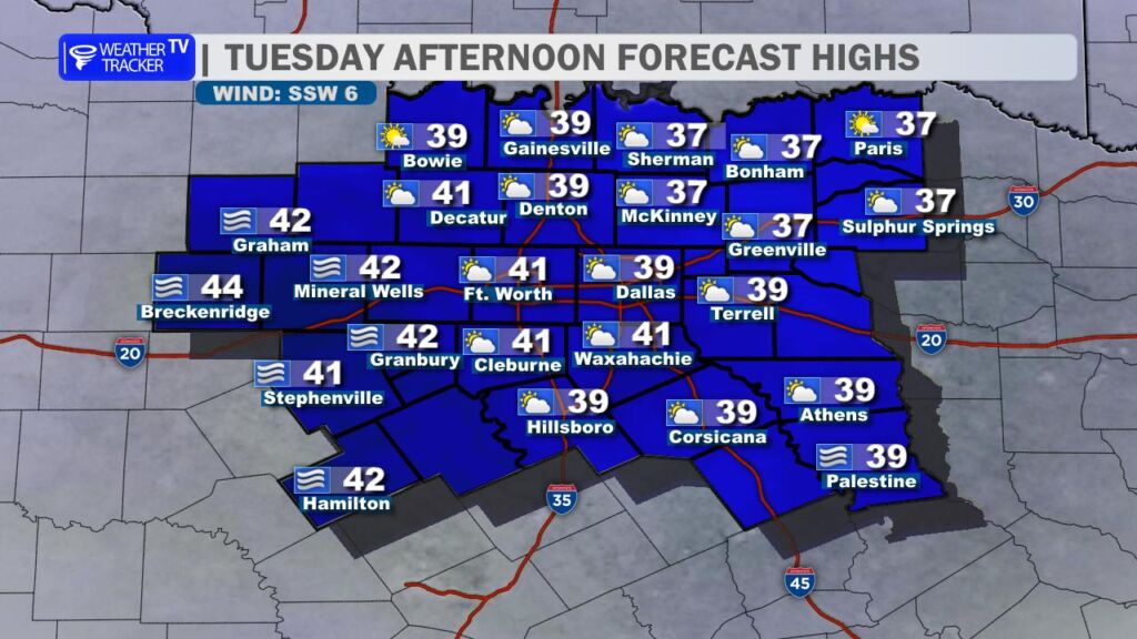
The good news is we will climb back above freezing this afternoon. High temperatures should reach around 40 degrees in the Metroplex under mostly sunny to partly sunny skies. That sunshine, combined with slightly milder air, will help improve road conditions through the afternoon as ice continues to melt on untreated surfaces.
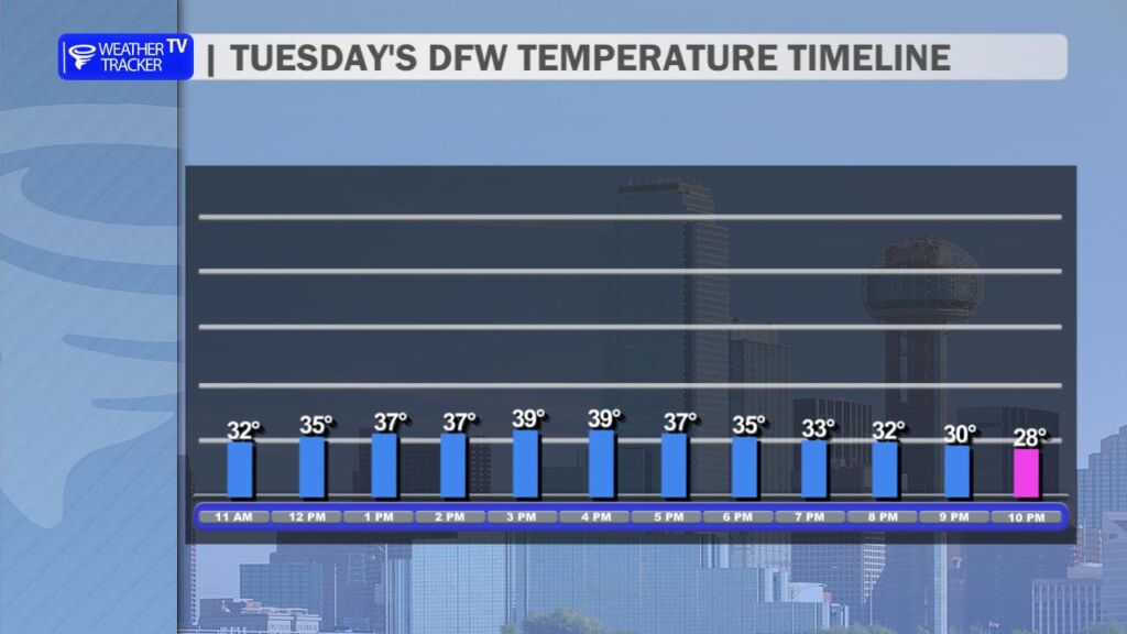
However, conditions will deteriorate again this evening. Temperatures are expected to fall back below freezing by around 8 PM, setting the stage for refreezing on area roadways overnight. To make matters worse, widespread freezing fog is likely to develop late tonight and persist into the Wednesday morning commute. That combination of refreezing moisture and freezing fog could create slick spots – especially on bridges, overpasses, and other elevated surfaces – along with reduced visibility. Some light glazing will be possible, and travel early Wednesday could be treacherous. If you can delay the morning commute again tomorrow, it would be a wise move.
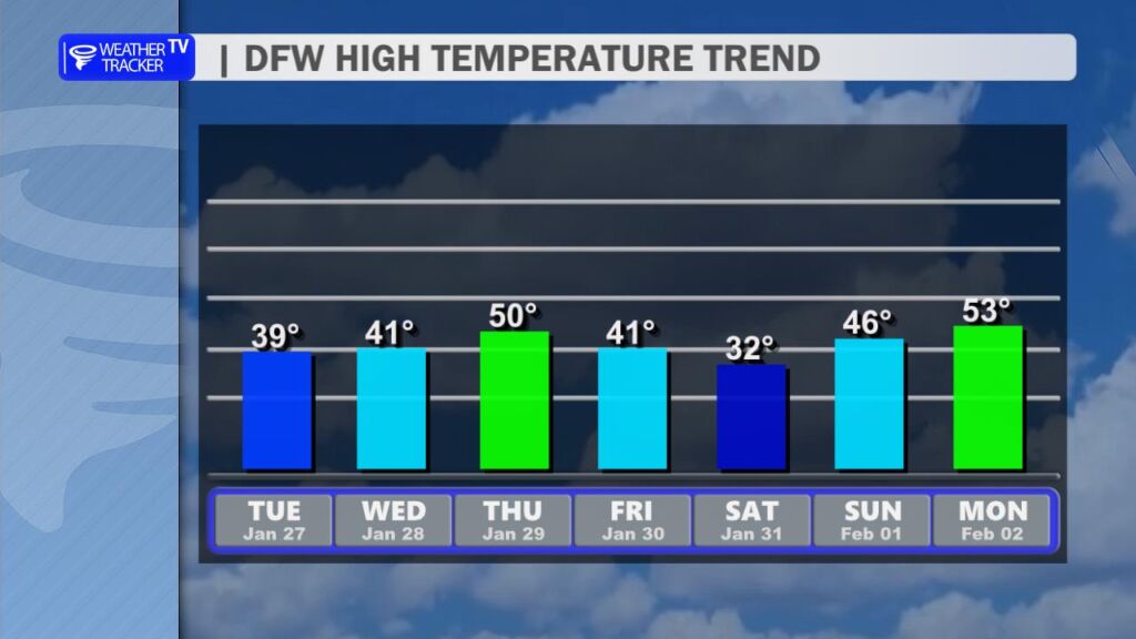
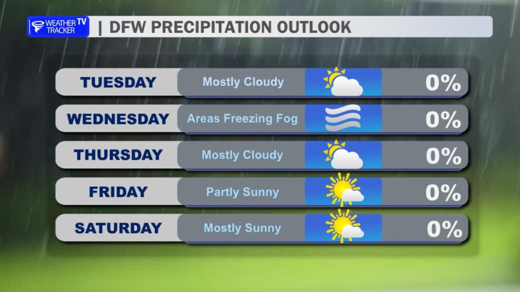
Looking ahead, temperatures will continue to gradually moderate through the middle of the week. But don’t get too comfortable – another Arctic front is expected to arrive late in the week, sending temperatures sharply downward once again heading into the weekend. Highs on Saturday may struggle to reach the lower 30s. At this time, the forecast remains dry, but the cold will certainly be back in full force.