Here’s a look at Live Temperatures across North Texas, MesoScan Radar and the Updated Forecast Map.
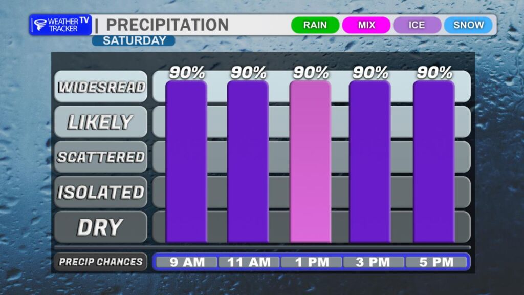
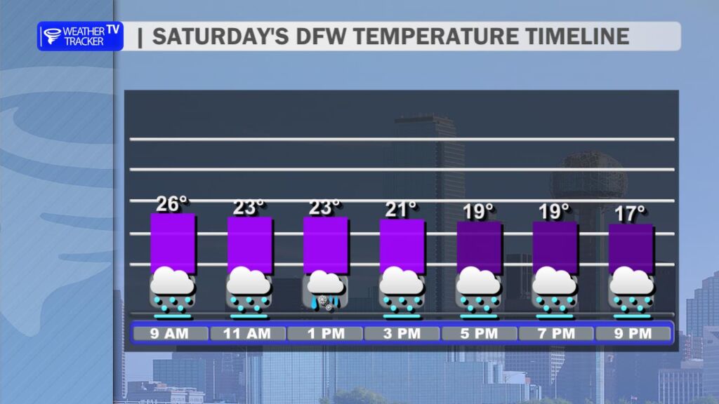
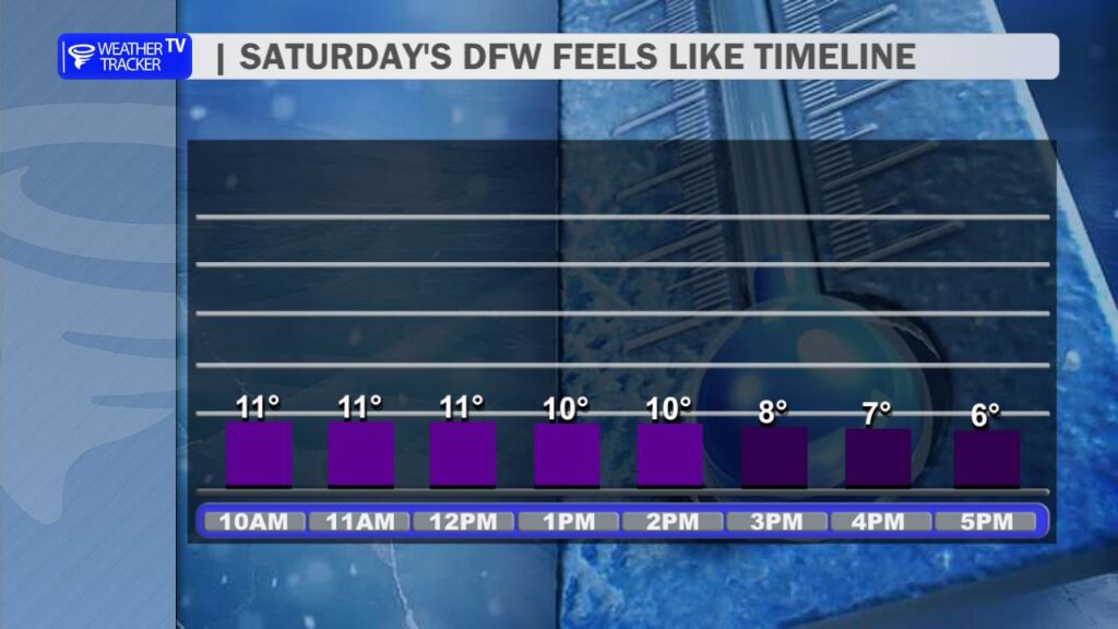
DFW THIS AFTERNOON Sleet with freezing rain likely. Sleet accumulation dusting or very light. Additional ice accumulation of up to trace amounts of an inch. Much cooler with highs in the upper 20s. Temperatures falling to around 20 late. North winds 10 to 15 mph. Chance of precipitation 90 percent. Wind chill values as low as 7 above. -William
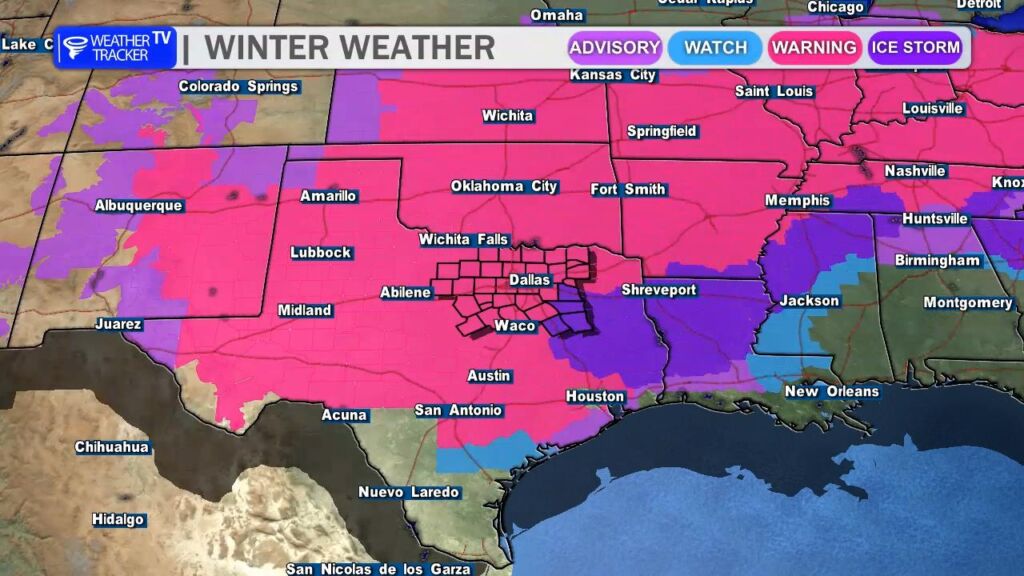
From William Cole: A Extreme Cold Warning has been extended in the Weather Tracker TV DFW coverage area from 6:00 PM Saturday until 9:00 AM Tuesday for Anderson, Freestone, Henderson, Navarro & Van Zandt Counties in North Texas.
Dangerously cold wind chills as low as 5 below zero expected.
Stay with William Cole and Weather Tracker TV Dallas – Fort Worth for continuing coverage, online, on our app and on TV. Let’s stay safe together.
From William Cole: A Extreme Cold Warning has been extended in the Weather Tracker TV DFW coverage area from 6:00 PM Saturday until 9:00 AM Tuesday for Bosque, Collin, Cooke, Dallas, Delta, Denton, Ellis, Erath, Fannin, Grayson, Hamilton, Hill, Hood, Hopkins, Hunt, Jack, Johnson, Kaufman, Lamar, Montague, Palo Pinto, Parker, Rains, Rockwall, Somervell, Stephens, Tarrant, Wise & Young Counties in North Texas.
Dangerously cold wind chills as low as 11 below zero expected.
Stay with William Cole and Weather Tracker TV Dallas – Fort Worth for continuing coverage, online, on our app and on TV. Let’s stay safe together.
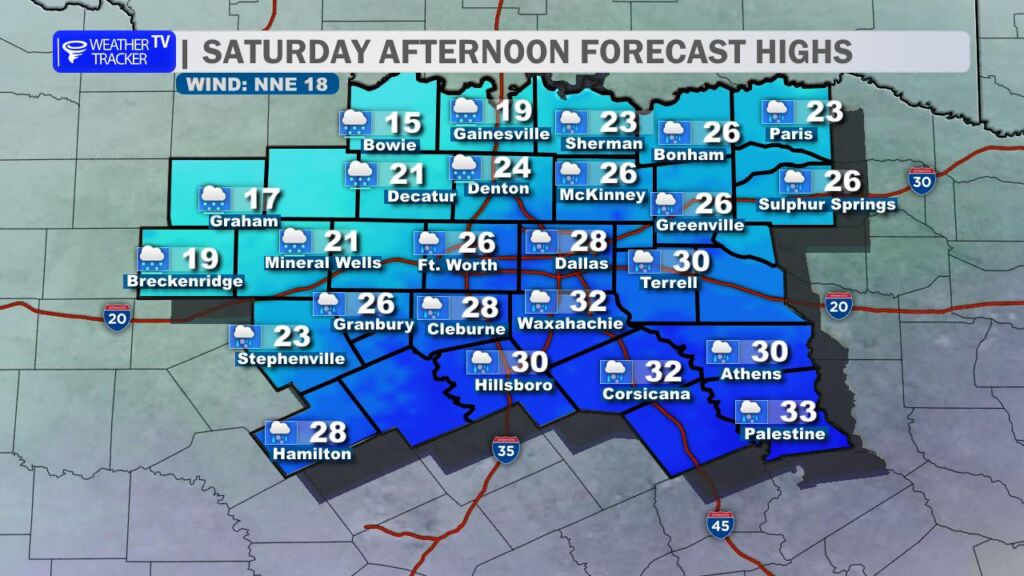
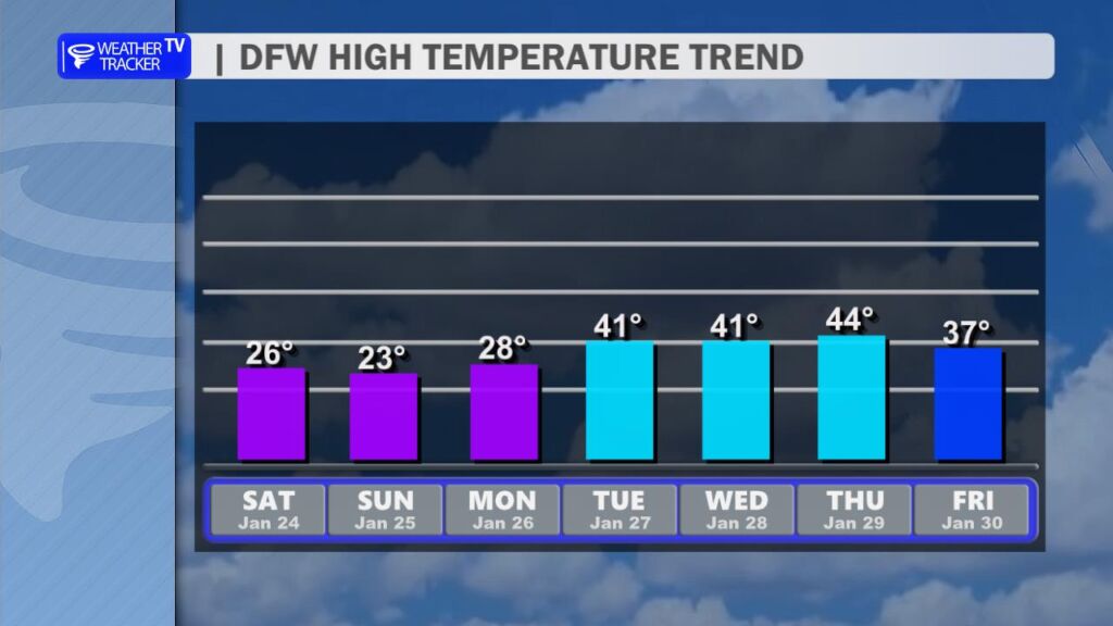
A significant winter storm is underway across the region as an arctic front continues to push south through North Texas. The front moved into the area overnight, bringing a sharp drop in temperatures that will continue through the day. High temperatures this afternoon will struggle to rise, remaining mostly in the 20s across much of North Texas.
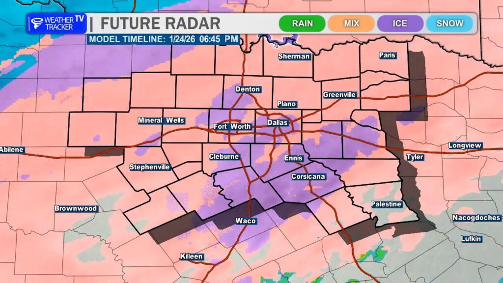
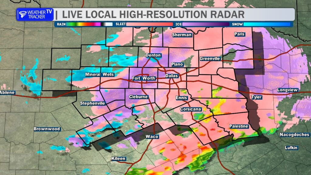
The first wave of winter precipitation moved through overnight and into the early morning hours, producing a mix of sleet, freezing rain, and snow. This initial round will gradually taper off through the early afternoon, allowing for a brief lull in activity.
However, a second and more impactful wave of precipitation is expected later today. Wave 2 will arrive this afternoon and continue through the evening and overnight hours, bringing another round of sleet, freezing rain, and snow to the region. Precipitation will slowly diminish early Sunday morning, though there may be a final burst of snow as the storm system pulls away.
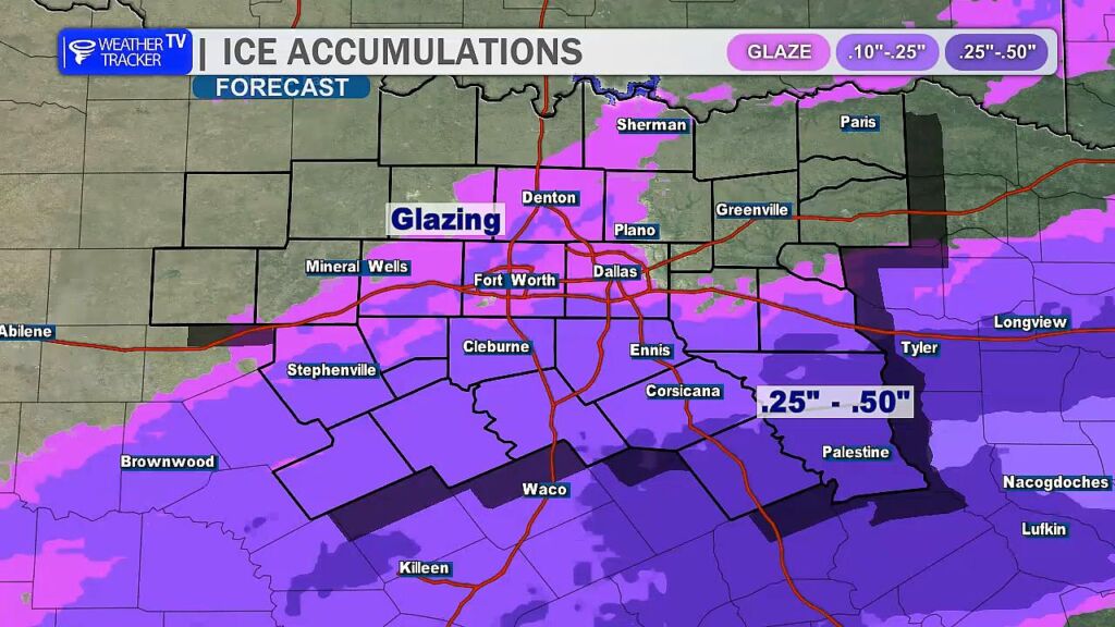
Winter precipitation totals are expected to be impressive across the region. While the DFW Metroplex should see only a light glaze of ice, southeastern counties could receive between a quarter and a half inch of ice accumulation. That amount would meet ice storm criteria and could lead to power outages and downed tree limbs in those areas.
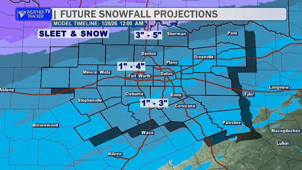
For much of North Texas, sleet will be the dominant form of winter precipitation. Accumulating sleet is expected to create hazardous travel conditions, with totals ranging from 1 to as much as 4 inches possible in the Metroplex.
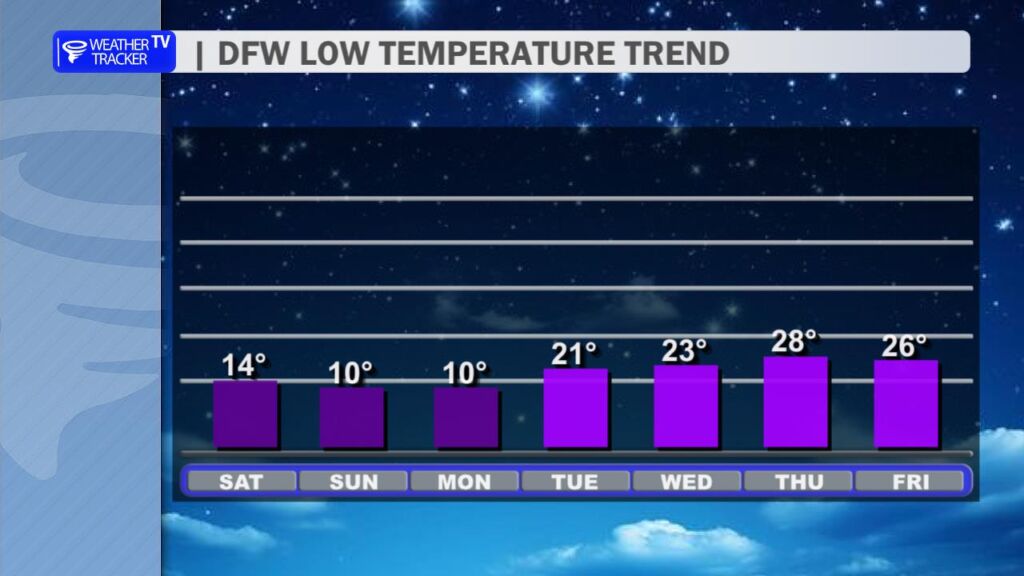
Dangerously cold temperatures and wind chills will persist, with an Extreme Cold Warning in effect across North Texas. The DFW Metroplex is expected to remain below freezing through at least mid-afternoon Tuesday, making this a prolonged, multi-day stretch of subfreezing conditions.
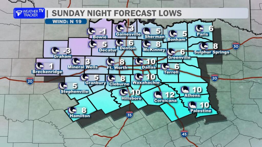
The coldest period of the storm will occur Sunday night into Monday morning, when lows across much of North Texas fall into the single digits. Some locations near the Red River could even drop below zero. Record low temperatures are expected in the DFW Metroplex during this time.
The best recommendation is to limit travel, take precautions to protect pipes, pets, and plants, and remain indoors and warm whenever possible.
7:30 AM: A mix of freezing rain, sleet, and snow continues across the Metroplex. Coverage will decrease through the morning before a second wave arrives later this afternoon. Temperatures and wind chills remain dangerously cold. Stay indoors and keep warm if possible.
DFW TODAY…Sleet and freezing rain this morning, then a chance of sleet and freezing rain this afternoon. Precipitation may be heavy at times this morning. Up to one inch of sleet accumulation. Ice accumulation of up to less than two tenths of an inch. Much cooler with highs in the upper 20s. Temperatures falling into the lower 20s this afternoon. North winds 10 to 15 mph. Chance of precipitation 90 percent. Wind chill values as low as 8 above. -William