Here’s a look at our Saturday late evening planner for the DFW Metroplex.

Here’s a look at our Saturday late evening planner for the DFW Metroplex.
Here is a look at Actual Highs from around North Texas today.

Actual Highs from around the Dallas – Fort Worth Metroplex today.

Today’s complete DFW Almanac.

Here’s a look at the Saturday evening planner for the DFW Metroplex.


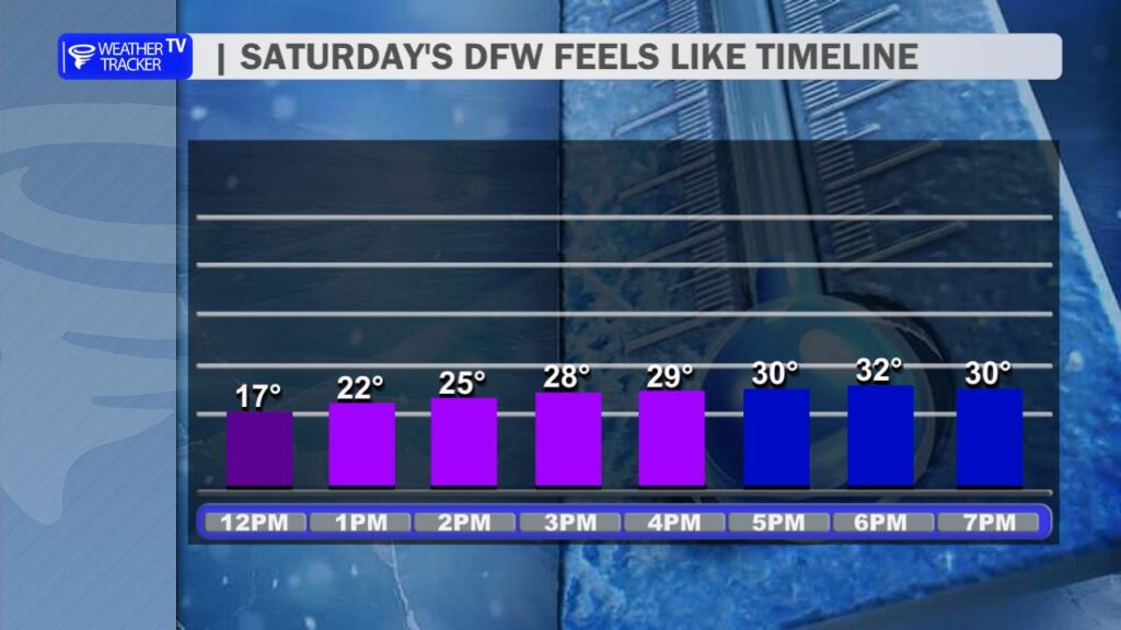
DFW TONIGHT Mostly clear in the evening, then becoming partly cloudy. Cold with lows in the mid 20s. Light and variable winds, becoming southeast around 5 mph after midnight. -William

Here’s a look at our Saturday evening commute in the DFW Metroplex.


Here’s a look at Live Temperatures across North Texas, MesoScan Radar and the Updated Forecast Map.
DFW THIS AFTERNOON Sunny, cooler with highs in the lower 30s. North winds 5 to 10 mph. -William


Good Saturday morning, North Texas!
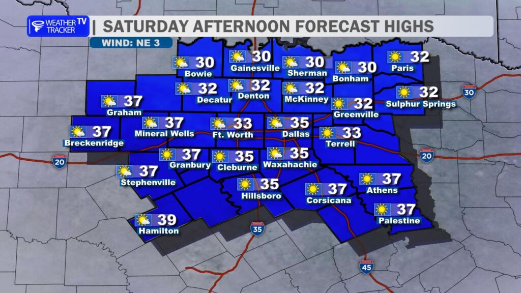
It’s a bitterly cold start across the region as Arctic air settled in overnight. Despite abundant sunshine later today, temperatures will have a hard time reaching the freezing mark for many locations. A brisk north wind will add an extra bite, keeping wind chill values in the teens and 20s through much of the day.
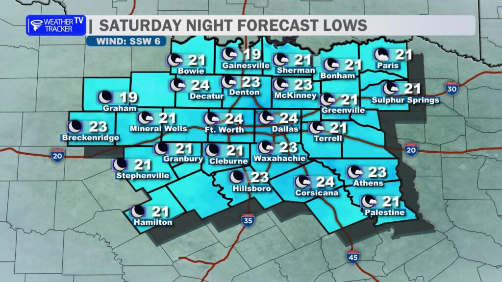
Tonight remains cold with clear skies and lows falling back into the teens and 20s. Winds will become light and variable, so wind chill concerns will ease somewhat, but it will still be a very cold night across the area.
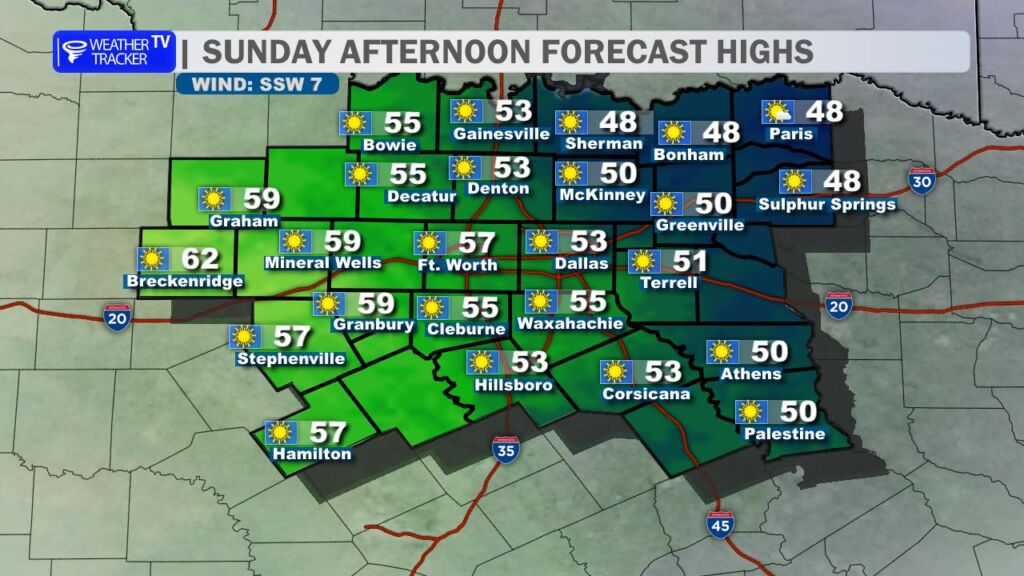
A gradual warming trend begins Sunday as sunshine continues and winds shift to the southwest. Afternoon highs will rebound into the 50s for most of North Texas, making it feel noticeably better compared to today.
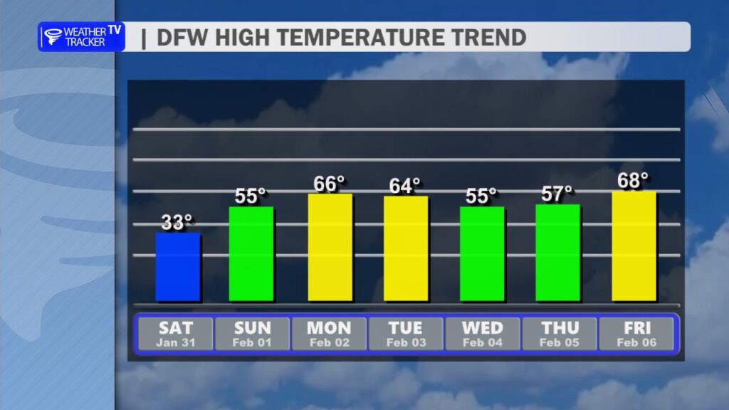
Milder air really settles in early next week. High temperatures climb back into the 60s on Monday and Tuesday before a weak midweek system brings a slight cool-down on Wednesday, trimming highs back into the 50s.

Rain chances are still in the forecast for Tuesday, though the latest data continues to push the better coverage south and southeast of the Dallas–Fort Worth area. For now, expect a cloudier day with at least a chance of showers for some locations. We’ll continue to monitor model trends as we get closer. -William
Here is a look at Actual Lows from around North Texas this morning.

Actual Lows from around the Dallas – Fort Worth Metroplex this morning.

Here’s a look at our Saturday planner for the DFW Metroplex.


DFW TODAY…Sunny, cooler with highs in the lower 30s. North winds 10 to 15 mph, diminishing to 5 to 10 mph this afternoon. Wind chill values as low as 6 above this morning. -William

