Here’s a look at our Wednesday late evening planner for the DFW Metroplex.

Here’s a look at our Wednesday late evening planner for the DFW Metroplex.
Here is a look at Actual Highs from around North Texas today.

Actual Highs from around the Dallas – Fort Worth Metroplex today.

Today’s complete DFW Almanac.

Thursday evening in the DFW Metroplex looks warm, breezy and humid with temps easing back through the 70s.

DFW tonight Partly cloudy in the evening, then becoming mostly cloudy. Lows in the upper 60s. Southeast winds 5 to 10 mph. -William


Here’s a look at our Wednesday evening commute in the DFW Metroplex.


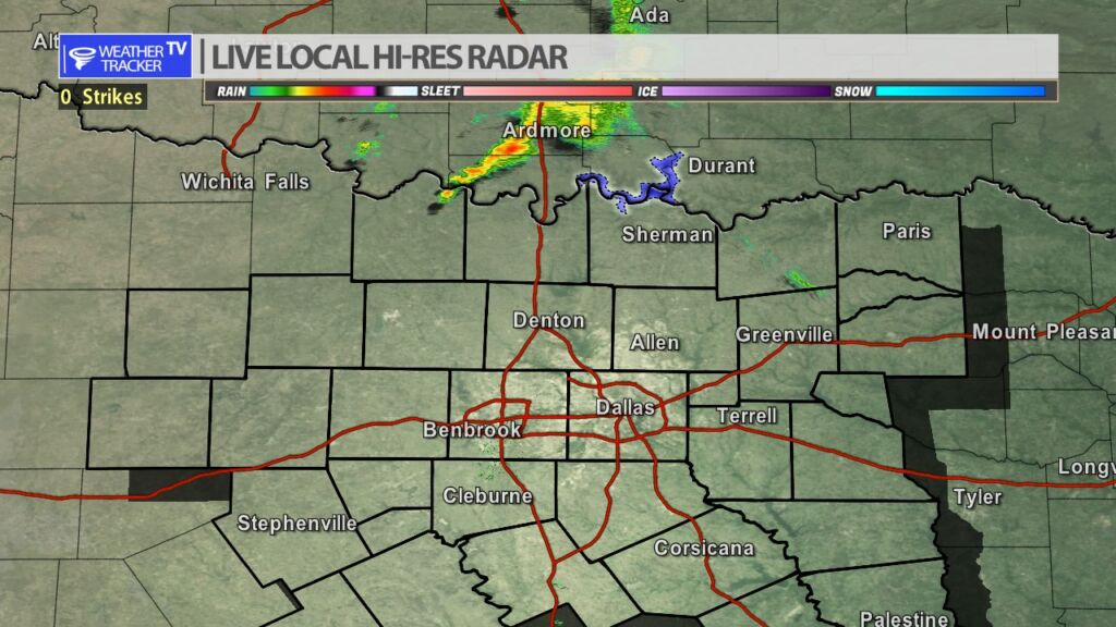
Here’s a look at Live Temperatures across North Texas, Local Radar and the Updated Forecast Map.
DFW this afternoon Partly sunny. Highs around 80. Southeast winds 5 to 10 mph. -William


Two rounds of severe weather will be possible in North Texas heading into the weekend with the first beginning late Thursday night and early Friday morning, and another later in the day on Saturday. Thursday we’ll be watching a line of storms form in the Texas Panhandle and the Big Country. That activity will push east and arrive in our western counites overnight. By 5 AM early Friday morning a line of storms will be approaching the DFW Metroplex. Heavy rain and some isolated severe weather will be possible with quarter sized hail and winds up to 60 MPH. The activity pushes east into early Friday afternoon, and additional isolated storms remain possible through Friday evening.
Saturday late afternoon thunderstorms develop near a dry line in our western counties, and those storms will most likely be supercell shaped. Very large hail, damaging winds and a tornado warning or two will be possible as those storms slowly push east Saturday evening. As a cold front begins to arrive from the northwest a line of storms will develop – still with the severe threat – late Saturday evening and the line of storms will push east overnight.
10 AM Radar- Watching a small area of showers along the Red River Valley. The activity is mainly in Oklahoma but will skirt our Red River counties this morning. Brief moderate rain possible.