Severe Risk Thursday

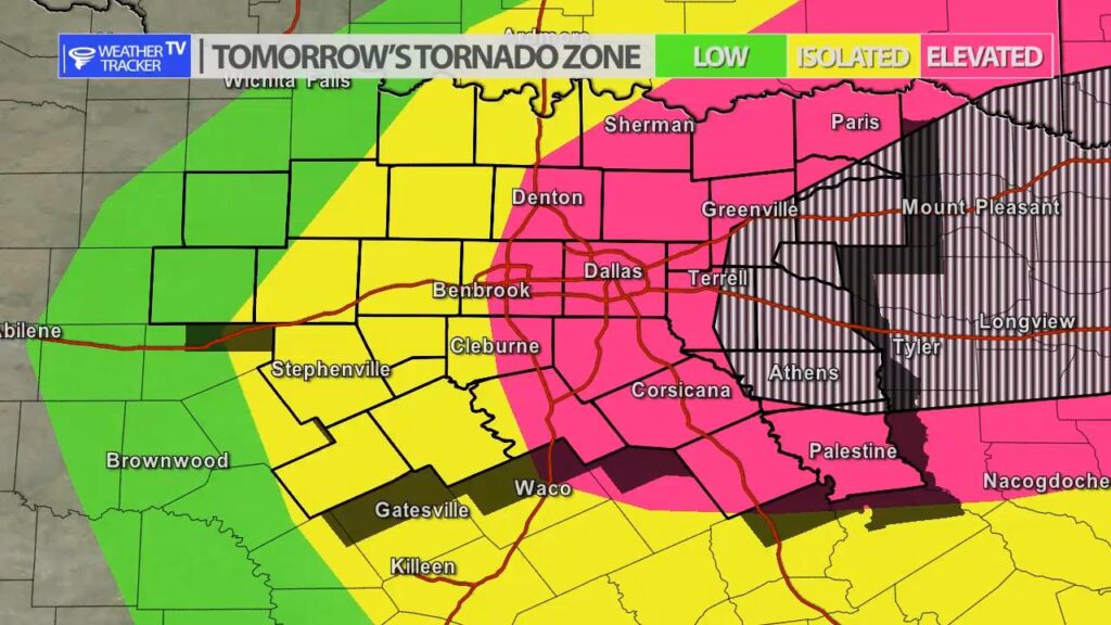
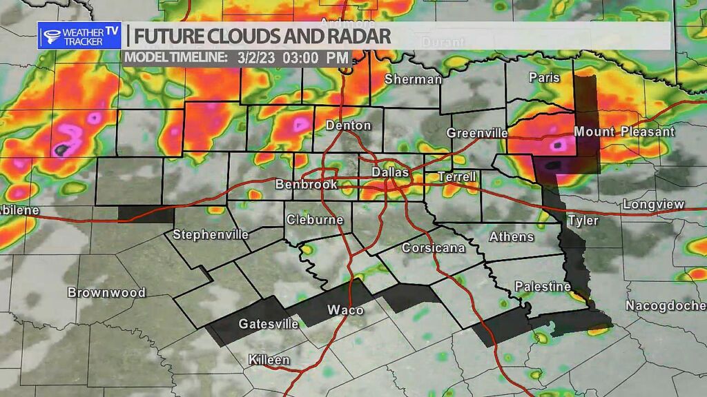
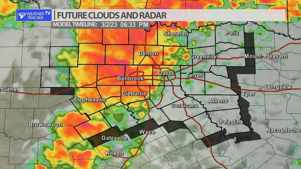
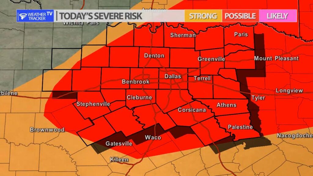
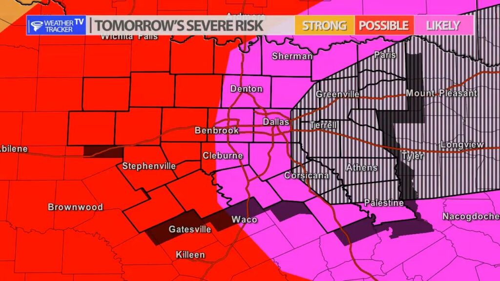
There is a more significant risk of severe weather tomorrow (Thursday) in North Texas. All hazards of severe weather will be possible including damaging hail, tornadoes and wind. Make sure you have a severe weather safety plan in place through the entire day – for yourself and your family. Super cells will be possible early in the day and evening before a line of storms sweeps through the area by late evening.

Future Radar 3 PM Thursday – Super cells possible.
Future Radar 6:30 PM Thursday – a line of storms pushes through

Severe Risk Today

There is a risk of severe weather today across North Texas. We already had one round of storms that moved through the Metroplex earlier this morning. Through the remainder of the day the coverage of storms looks to be pretty spotty. Anything that does develop would have a severe risk – mainly with a large hail threat.

NOW UPDATE | Wednesday 9:14 AM Hopkins, Hunt, Rains & Van Zandt Counties

Texas Weather Tracker TV Alert

From William Cole: A strong T-Storm will impact portions of southeastern Hunt, northwestern Van Zandt, southwestern Hopkins and Rains Counties through 945 AM

At 914 AM , Live Radar was tracking a strong T-Storm over Lake Tawakoni State Park, or 9 miles north of Wills Point, moving east at 50 mph.

Nickel Size Hail. Minor Damage To Outdoor Objects Is Possible.

Stay with William Cole and Weather Tracker TV Dallas – Fort Worth for continuing coverage, online, on our app and on TV. Let’s stay safe together.

Severe Weather Update 9:05 AM Hunt & Kaufman Counties

Texas Weather Tracker TV Alert

From William Cole: A Severe T-Storm Warning continues for for Hunt & Kaufman Counties in North Texas until 9:15 AM.

At 904 AM , a severe T-Storm was located near New Terrell City Lake, or 8 miles northwest of Wills Point, moving east at 50 mph.

Primary Threats: Quarter Size Hail.

Stay with William Cole and Weather Tracker TV Dallas – Fort Worth for continuing coverage, online, on our app and on TV. Let’s stay safe together.

8:51 AM | T-Storm Warning Hunt, Kaufman, Rockwall & Van Zandt Counties until 9:15 AM Wednesday

Texas Weather Tracker TV Alert

From William Cole: A Severe T-Storm Warning has been issued in the Weather Tracker TV DFW coverage area for Hunt, Kaufman, Rockwall & Van Zandt Counties in North Texas until 9:15 AM.

At 851 AM , a severe T-Storm was located over Terrell, moving east at 50 mph.

Hometowns Impacted: Rockwall, Terrell, Wills Point, West Tawakoni, Talty, Quinlan, East Tawakoni, Hawk Cove, Lake Tawakoni, Lake Tawakoni State Park, New Terrell City Lake, Mclendon-Chisholm, Elmo, Oak Ridge, Alsa And Lawrence.

Primary Threats: Quarter Size Hail.

Stay with William Cole and Weather Tracker TV Dallas – Fort Worth for continuing coverage, online, on our app and on TV. Let’s stay safe together.

Severe Weather Update 8:49 AM Kaufman & Rockwall Counties

Texas Weather Tracker TV Alert

From William Cole: A Severe T-Storm Warning continues for for Kaufman & Rockwall Counties in North Texas until 9:00 AM.

At 849 AM , a severe T-Storm was located over Talty, or near Terrell, moving east at 45 mph.

Primary Threats: Quarter Size Hail.

Stay with William Cole and Weather Tracker TV Dallas – Fort Worth for continuing coverage, online, on our app and on TV. Let’s stay safe together.

Severe Weather Update 8:42 AM Kaufman & Rockwall Counties

Texas Weather Tracker TV Alert

From William Cole: A Severe T-Storm Warning continues for for Kaufman & Rockwall Counties in North Texas until 9:00 AM.

At 842 AM , a severe T-Storm was located near Crandall, or near Forney, moving east at 45 mph.

Primary Threats: Quarter Size Hail.

Stay with William Cole and Weather Tracker TV Dallas – Fort Worth for continuing coverage, online, on our app and on TV. Let’s stay safe together.

Severe Weather Update 8:32 AM Dallas, Kaufman & Rockwall Counties

Texas Weather Tracker TV Alert

From William Cole: A Severe T-Storm Warning continues for for Dallas, Kaufman & Rockwall Counties in North Texas until 9:00 AM.

At 832 AM , a severe T-Storm was located near Seagoville, moving east at 45 mph.

Primary Threats: Quarter Size Hail.

Stay with William Cole and Weather Tracker TV Dallas – Fort Worth for continuing coverage, online, on our app and on TV. Let’s stay safe together.