Current Set Up Across the Nation

DFW today Cloudy. A chance of showers and T-Storms this morning, then a slight chance of showers and T-Storms this afternoon. Much cooler with highs in the mid 60s. North winds 5 to 10 mph. Chance of rain 50 percent. -William

Here’s a look at Local Radar and Live Temperatures across North Texas.
DFW the rest of tonight: Mostly cloudy with showers likely with a chance of T-Storms. Patchy fog. Lows in the upper 50s. North winds 5 to 10 mph. Chance of rain 70 percent.


From William Cole: Strong T-Storms will impact portions of northeastern Cooke and central Grayson Counties through 300 AM
At 213 AM , Live Radar was tracking strong T-Storms along a line extending from near Marietta to near Lindsay. Movement was east at 45 mph.
Winds In Excess Of 40 Mph And Half Inch Hail. Gusty Winds Could Knock Down Tree Limbs And Blow Around Unsecured Objects. Minor Damage To Outdoor Objects Is Possible.
Stay with William Cole and Weather Tracker TV Dallas – Fort Worth for continuing coverage, online, on our app and on TV. Let’s stay safe together.

William’s North Texas Hazardous Weather Forecast this Evening:
T-Storm chances increase this evening across Western North Texas and all of North Texas overnight. A few storms may be capable of producing small hail this evening.
DFW tonight Mostly cloudy. A chance of sprinkles with a slight chance of T-Storms in the evening, then a chance of showers and T-Storms after midnight. Patchy fog after midnight. Lows in the upper 50s. South winds 5 to 10 mph. Chance of rain 50 percent. -William


Here’s a look at Live Temperatures across North Texas, Local Radar and the Updated Forecast Map.
DFW -William


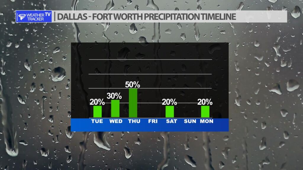
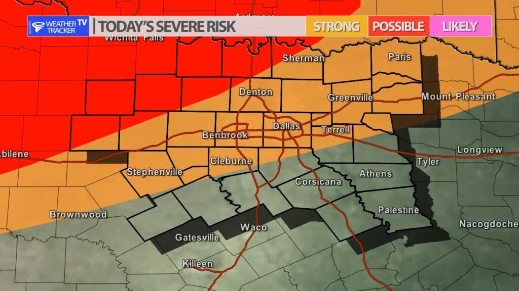
A cold front will stall across North Texas over the next 48 hours and will be the focus of scattered rain and T-Storms. The coverage of rain still appears to best on Thursday, but regardless the forecast looks unsettled tonight and into Wednesday as well. The Storm Prediction Center officially has a severe risk this evening and tonight to the northwest of Dallas – Fort Worth. Isolated severe storms with hail up to the size of quarters is possible. I’m not anticipating organized or widespread severe weather over the next two days.