DFW Early Wednesday Afternoon Update

Texas Weather Tracker TV Alert

Here’s a look at Live Temperatures across North Texas, Local Radar and the Updated Forecast Map.

DFW this afternoon Cloudy with a chance of sprinkles with a slight chance of T-Storms. Much cooler with highs in the upper 50s. North winds 5 to 10 mph. Chance of rain 20 percent. -William

Texas Weather Tracker TV Alert

Texas Weather Tracker TV Alert

NOW UPDATE | Wednesday 11:07 AM Palo Pinto & Stephens Counties

Texas Weather Tracker TV Alert

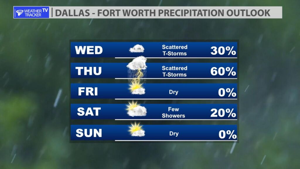
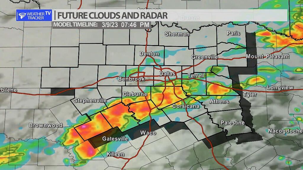
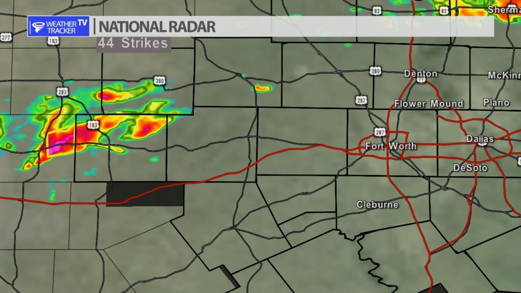
From William Cole: A strong T-Storm will impact portions of northeastern Stephens and northwestern Palo Pinto Counties through 1130 AM

At 1107 AM , Live Radar was tracking a strong T-Storm near Caddo, or 14 miles east of Breckenridge, moving east at 40 mph.

Winds In Excess Of 40 Mph And Penny Size Hail. Gusty Winds Could Knock Down Tree Limbs And Blow Around Unsecured Objects. Minor Damage To Outdoor Objects Is Possible.

Stay with William Cole and Weather Tracker TV Dallas – Fort Worth for continuing coverage, online, on our app and on TV. Let’s stay safe together.

NOW UPDATE | Wednesday 10:42 AM Stephens County

Texas Weather Tracker TV Alert

From William Cole: A strong T-Storm will impact portions of central Stephens County through 1115 AM

At 1042 AM , Live Radar was tracking a strong T-Storm over Breckenridge, moving east at 30 mph.

Winds In Excess Of 40 Mph And Penny Size Hail. Gusty Winds Could Knock Down Tree Limbs And Blow Around Unsecured Objects. Minor Damage To Outdoor Objects Is Possible.

Stay with William Cole and Weather Tracker TV Dallas – Fort Worth for continuing coverage, online, on our app and on TV. Let’s stay safe together.

Rain Chances

Rain and T-Storm probabilities taper back for most of us today and tonight. Tomorrow as another weather system moves out into the Great Plains we will have a better opportunity of rain and storms in North Texas. It appears right now the best coverage of rain and storms will be from I-20 south later in the day.

Future radar Thursday — 7:45 PM

10:10 AM Radar

10:10 AM Radar Snapshot

While radar has become quieter as we have gone through the morning we are watching one cell that is moving into Stephens County (our far western county). The cell has been severe warned out in the Big Country with quarter sized hail. We’ll track it as it moves toward northeast at 35 MPH near and north of the Breckenridge area.

NOW UPDATE | Wednesday 10:11 AM Stephens County

Texas Weather Tracker TV Alert

From William Cole: A strong T-Storm will impact portions of west central Stephens County through 1045 AM

At 1011 AM , Live Radar was tracking a strong T-Storm over Ibex, or 11 miles west of Breckenridge, moving east at 40 mph.

Winds In Excess Of 40 Mph And Penny Size Hail. Gusty Winds Could Knock Down Tree Limbs And Blow Around Unsecured Objects. Minor Damage To Outdoor Objects Is Possible.

Stay with William Cole and Weather Tracker TV Dallas – Fort Worth for continuing coverage, online, on our app and on TV. Let’s stay safe together.

Actual Morning Lows

You can see where the cold front was overnight with actual lows this morning. Most of North Texas behind the front in the 40s and 50s with our southeastern counties just ahead of it – 60s down there.