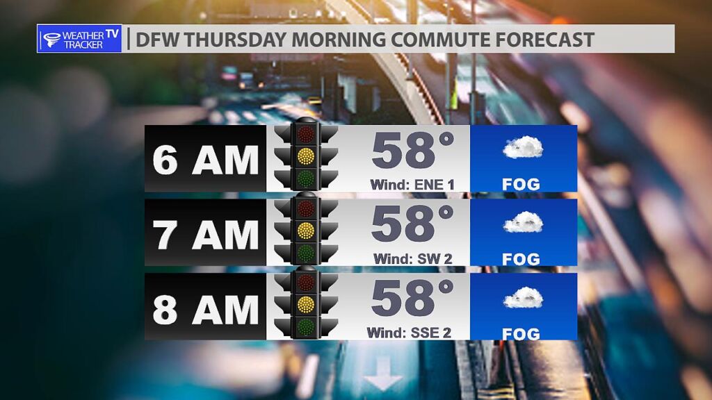
Expect a cool and damp Thursday morning commute in the Metroplex. Areas of dense fog will reduce visibility to less than 1/4 of a mile. Give yourself extra time this morning. A Dense Fog Advisory is in effect until 10 AM.
Expect a cool and damp Thursday morning commute in the Metroplex. Areas of dense fog will reduce visibility to less than 1/4 of a mile. Give yourself extra time this morning. A Dense Fog Advisory is in effect until 10 AM.

From William Cole: A Dense Fog Advisory has been issued in the Weather Tracker TV DFW coverage area from 4:50 AM Thursday until 10:00 AM Thursday for Bosque, Collin, Dallas, Denton, Ellis, Erath, Freestone, Hamilton, Hill, Hood, Jack, Johnson, Kaufman, Navarro, Palo Pinto, Parker, Rockwall, Somervell, Stephens, Tarrant, Wise & Young Counties in North Texas.
Visibility one quarter mile or less in dense fog.
Stay with William Cole and Weather Tracker TV Dallas – Fort Worth for continuing coverage, online, on our app and on TV. Let’s stay safe together.

From William Cole: A strong T-Storm will impact portions of Lamar County through 430 AM
At 345 AM , Live Radar was tracking a strong T-Storm near Paris and another near Roxton. Both storms are moving east at 30 mph.
Winds In Excess Of 40 Mph And Nickel Size Hail. Gusty Winds Could Knock Down Tree Limbs And Blow Around Unsecured Objects. Minor Damage To Outdoor Objects Is Possible.
Stay with William Cole and Weather Tracker TV Dallas – Fort Worth for continuing coverage, online, on our app and on TV. Let’s stay safe together.
From William Cole: Strong T-Storms will impact portions of northwestern Lamar and Fannin Counties through 330 AM
At 305 AM , Live Radar was tracking a cluster of strong T-Storms extending from near Honey Grove to Bonham. Movement was east at 35 mph.
Penny Size Hail. Minor Damage To Outdoor Objects Is Possible.
Stay with William Cole and Weather Tracker TV Dallas – Fort Worth for continuing coverage, online, on our app and on TV. Let’s stay safe together.

Here’s a look at Local Radar and Live Temperatures across North Texas.
DFW the rest of tonight: Cloudy with a 40 percent chance of showers and T-Storms. Areas of fog. Lows in the mid 50s. East winds around 5 mph.


From William Cole: A Severe T-Storm Warning continues for for Fannin & Grayson Counties in North Texas until 2:45 AM.
At 157 AM , a severe T-Storm was located over Whitewright, or 13 miles west of Bonham, moving east at 25 mph.
Primary Threats: Quarter Size Hail.
Stay with William Cole and Weather Tracker TV Dallas – Fort Worth for continuing coverage, online, on our app and on TV. Let’s stay safe together.

From William Cole: A Flash Flood Warning has been issued in the Weather Tracker TV DFW coverage area for Grayson County in North Texas until 4:30 AM.
At 146 AM , emergency management reported flooding in Gunter and Howe with multiple impassable roads due to high water. Flash flooding is imminent or already occurring.
Remember if you see water across a roadway do not drive through it. Turn Around Don’t Drown.
Stay with William Cole and Weather Tracker TV Dallas – Fort Worth for continuing coverage, online, on our app and on TV. Let’s stay safe together.

From William Cole: A Severe T-Storm Warning has been issued in the Weather Tracker TV DFW coverage area for Fannin & Grayson Counties in North Texas until 2:45 AM.
At 138 AM , a severe T-Storm was located over Gunter. Another severe T-Storm was located over Tom Bean. Both storms are moving east at 35 mph.
Hometowns Impacted: Sherman, Bonham, Van Alstyne, Howe, Whitewright, Gunter, Bells, Tom Bean, Savoy, Ector, Trenton, Ravenna, Dorchester, Valley Lake, Randolph, Boyd, Cannon, Ida, Elmont And Pilot Grove.
Primary Threats: Quarter Size Hail.
Stay with William Cole and Weather Tracker TV Dallas – Fort Worth for continuing coverage, online, on our app and on TV. Let’s stay safe together.
From William Cole: A strong T-Storm will impact portions of northeastern Denton, northwestern Collin, southeastern Cooke and southern Grayson Counties through 145 AM
At 1257 AM , Live Radar was tracking a strong T-Storm near Gunter and another over Ray Roberts Lake. Both storms are moving east northeast at 25 mph.
Winds In Excess Of 30 Mph And Nickel Size Hail. Gusty Winds Could Knock Down Tree Limbs And Blow Around Unsecured Objects. Minor Damage To Outdoor Objects Is Possible.
Stay with William Cole and Weather Tracker TV Dallas – Fort Worth for continuing coverage, online, on our app and on TV. Let’s stay safe together.
From William Cole: A strong T-Storm will impact portions of northern Denton, northwestern Collin, southeastern Cooke and southwestern Grayson Counties through 100 AM
At 1224 AM , Live Radar was tracking a strong T-Storm over Pilot Point, and another 3 miles west of Sanger. Both T-Storms are moving east northeast at 30 mph.
Winds In Excess Of 30 Mph And Penny Size Hail. Gusty Winds Could Knock Down Tree Limbs And Blow Around Unsecured Objects. Minor Damage To Outdoor Objects Is Possible.
Stay with William Cole and Weather Tracker TV Dallas – Fort Worth for continuing coverage, online, on our app and on TV. Let’s stay safe together.