2:06 PM | T-Storm Warning Palo Pinto, Stephens & Young Counties until 2:45 PM Thursday

Texas Weather Tracker TV Alert

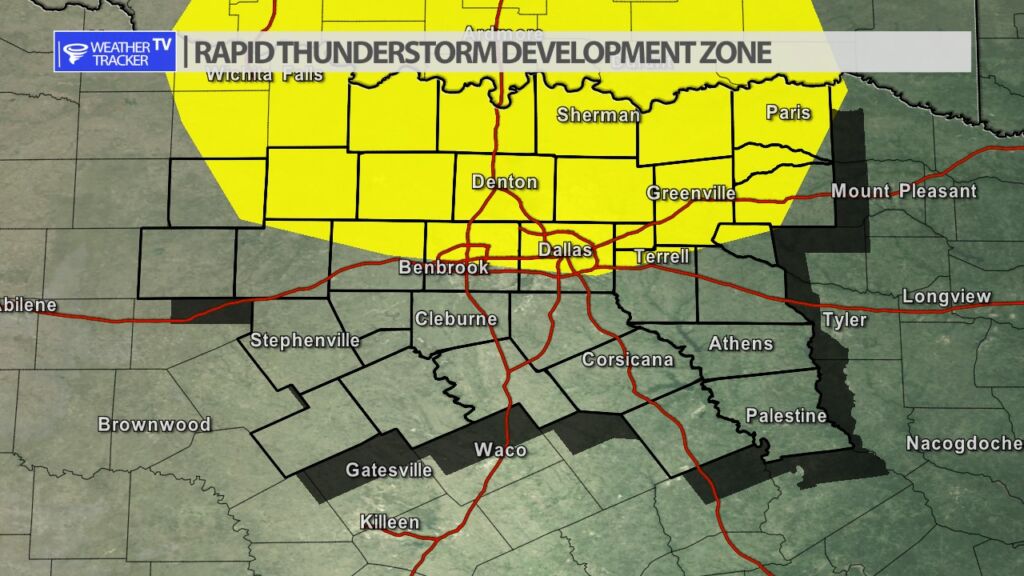
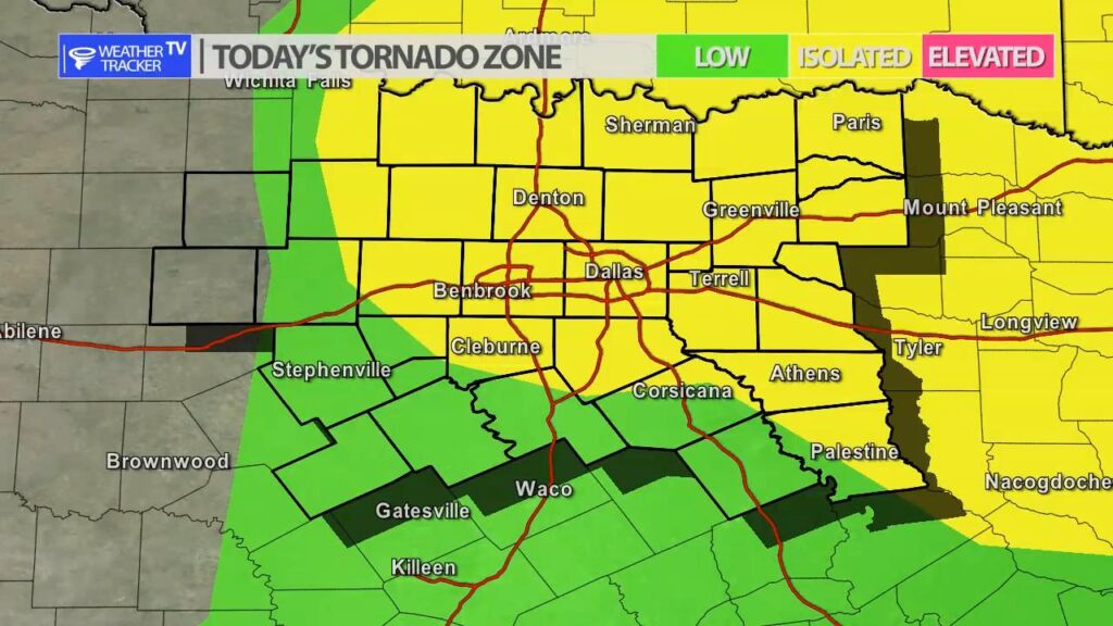
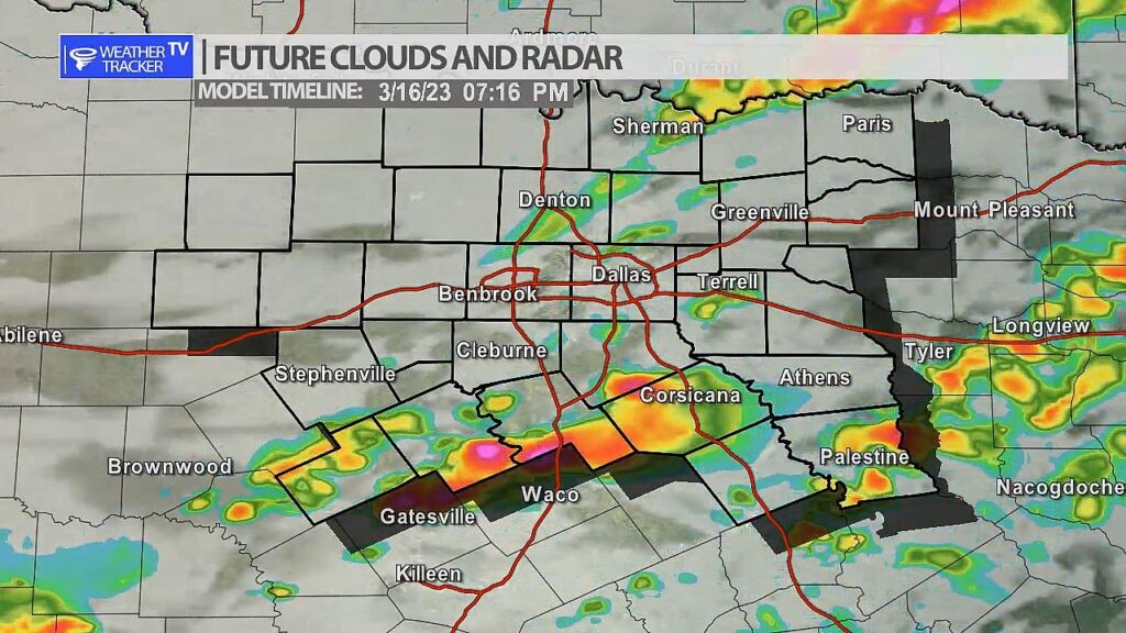
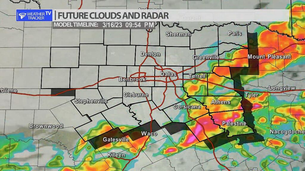
From William Cole: A Severe T-Storm Warning has been issued in the Weather Tracker TV DFW coverage area for Palo Pinto, Stephens & Young Counties in North Texas until 2:45 PM.

At 205 PM , a severe T-Storm was located near Breckenridge, moving east at 45 mph.

Hometowns Impacted: Breckenridge, Graford, Palo Pinto, Possum Kingdom Lake, Possum Kingdom State Park, Crystal Falls, Caddo, Eliasville, Ivan And South Bend.

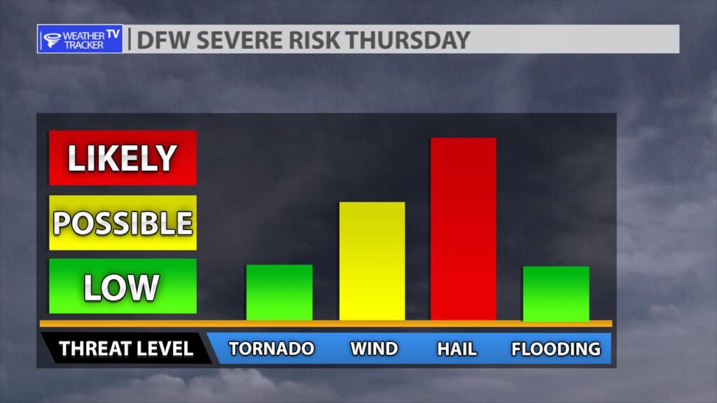
Primary Threats: 60 Mph Wind Gusts And Quarter Size Hail.

Stay with William Cole and Weather Tracker TV Dallas – Fort Worth for continuing coverage, online, on our app and on TV. Let’s stay safe together.

NOW UPDATE | Thursday 1:57 PM Stephens County

Texas Weather Tracker TV Alert

From William Cole: A strong T-Storm will impact portions of northern Stephens County through 230 PM

At 156 PM , Live Radar was tracking a strong T-Storm near Breckenridge, moving east at 40 mph.

Winds In Excess Of 40 Mph And Nickel Size Hail. Gusty Winds Could Knock Down Tree Limbs And Blow Around Unsecured Objects. Minor Damage To Outdoor Objects Is Possible.

Stay with William Cole and Weather Tracker TV Dallas – Fort Worth for continuing coverage, online, on our app and on TV. Let’s stay safe together.

32 PM | TORNADO WATCH until 8:00 PM Thursday

Texas Weather Tracker TV Alert

From William Cole: A TORNADO WATCH has been issued in the Weather Tracker TV DFW coverage area for the following counties in North Texas until 8:00 PM Thursday. Bosque, Collin, Cooke, Dallas, Delta, Denton, Ellis, Erath, Fannin, Grayson, Hill, Hood, Hopkins, Hunt, Jack, Johnson, Kaufman, Lamar, Montague, Palo Pinto, Parker, Rains, Rockwall, Somervell, Stephens, Tarrant, Wise & Young.

We’ll have Live Severe Weather Coverage on the channel – which includes Texas’ #1 Storm Chasing Team – as needed. Be sure to download our free Weather Tracker TV DFW mobile app and add our Live channel to your Roku, Apple or Amazon Fire TV device.

Stay with William Cole and Weather Tracker TV Dallas – Fort Worth for continuing coverage, online, on our app and on TV. Let’s stay safe together.

DFW Early Thursday Afternoon Update

Texas Weather Tracker TV Alert

Here’s a look at Live Temperatures across North Texas, Local Radar and the Updated Forecast Map.

DFW today Cloudy this morning, then becoming partly sunny. A chance of T-Storms. Showers likely this morning, then a chance of showers this afternoon. Some T-Storms may be severe. Breezy with highs in the mid 70s. South winds 15 to 20 mph, increasing to 20 to 25 mph this afternoon. Chance of rain 70 percent. -William

Texas Weather Tracker TV Alert

Texas Weather Tracker TV Alert

Severe Weather Possible Today

The risk of severe weather returns to North Texas today with large hail, damaging winds and even a few tornado warnings possible. Scattered T-Storms are possible through the afternoon, but the threat of organized severe weather begins today at 4 pm near and west of the I-35 corridor. A dryline will push into the area and will be the focus of T-Storm development. Any storms that form during this time will have a large hail threat (larger than golf balls). A tornado warning or two is also possible. As we progress into the evening hours any scattered activity will begin to form into a line of storms and push through our southeastern counties with a damaging wind threat developing. We will have more updates through the day and as always live severe weather coverage on the channel as needed.

Today’s North Texas Hazardous Weather Forecast

Texas Weather Tracker TV Alert

William’s North Texas Hazardous Weather Forecast for Thursday:

Showers and T-Storms are expected to develop today with a severe threat this afternoon and evening. Large hail (greater than golf ball size) will be the main threat with initial storm development. As a cold front approaches late this afternoon, a damaging wind threat will increase. There will also be a potential for tornadoes into the evening hours.

7:39 AM | Wind Advisory until 10:00 AM Friday

Texas Weather Tracker TV Alert

From William Cole: A Wind Advisory has been issued in the Weather Tracker TV DFW coverage area from 5:00 PM Thursday until 10:00 AM Friday for Anderson, Bosque, Collin, Cooke, Dallas, Delta, Denton, Ellis, Erath, Fannin, Freestone, Grayson, Hamilton, Henderson, Hill, Hood, Hopkins, Hunt, Jack, Johnson, Kaufman, Lamar, Montague, Navarro, Palo Pinto, Parker, Rains, Rockwall, Somervell, Stephens, Tarrant, Van Zandt, Wise & Young Counties in North Texas.

Post-frontal north-northwest winds of 20 to 30 mph with gusts up to 45 mph expected.

Stay with William Cole and Weather Tracker TV Dallas – Fort Worth for continuing coverage, online, on our app and on TV. Let’s stay safe together.