DFW tonight Mostly clear. Lows in the lower 70s. East winds around 5 mph. -William

DFW tonight Mostly clear. Lows in the lower 70s. East winds around 5 mph. -William

From William Cole: A Air Quality Alert has been issued for the following counties in North Texas until Friday August 26. Collin, Dallas, Denton, Ellis, Henderson, Hunt, Johnson, Kaufman, Parker, Rockwall, Tarrant & Wise.
OZONE ACTION DAY The Texas Commission on Environmental Quality (TCEQ) has issued an Ozone Action Day for the Dallas-Fort Worth area for Friday, August 26, 2022. Atmospheric conditions are expected to be favorable for producing high levels of ozone air pollution in the Dallas-Fort Worth area on Friday. You can help prevent ozone pollution by sharing a ride, walking, riding a bicycle, taking your lunch to work, avoiding drive-through lanes, conserving energy, and keeping your vehicle properly tuned. For more information on ozone: Ozone: The Facts (www.tceq.texas.gov/goto/ozonefacts) Air North Texas: (www.airnorthtexas.org) EPA Air Now (www.airnow.gov/index.cfm?action.local_state&STATEID=45&TAB=0) Take care of Texas (www.takecareoftexas.org) North Central Texas Council of Governments Air Quality (www.nctcog.org/trans/air/index.asp)
Stay with William Cole and Weather Tracker TV Dallas – Fort Worth for continuing coverage online, on our free mobile app and on TV thru Roku, Apple and Amazon Fire TV.

Here’s a look at Live Temperatures across North Texas, Local Radar and the Updated Forecast Map.
DFW this afternoon Mostly sunny with a less than 20 percent chance of showers. Highs around 90. Northeast winds 5 to 10 mph. -William


From the National Hurricane Center:
For the North Atlantic Caribbean Sea and the Gulf of Mexico:Near the Windward Islands:A well-defined tropical wave is moving across the Windward Islandswhile producing disorganized shower and T-Storm activity.This system is expected to move westward at about 15 mph during thenext several days, and environmental conditions could become moreconducive for slow development when it moves across the central andwestern Caribbean Sea early next week.* Formation chance through 48 hours low near 0 percent.* Formation chance through 5 days low 20 percent.Eastern Tropical Atlantic:A tropical wave has moved off the west coast of Africa and isproducing a large area of disorganized showers and T-Storms.Environmental conditions could support some slow development ofthis system through early next week while it moves quickly westwardacross the eastern and central tropical Atlantic at 15 to 20 mph.* Formation chance through 48 hours low 10 percent.* Formation chance through 5 days low 20 percent.Forecaster Berg
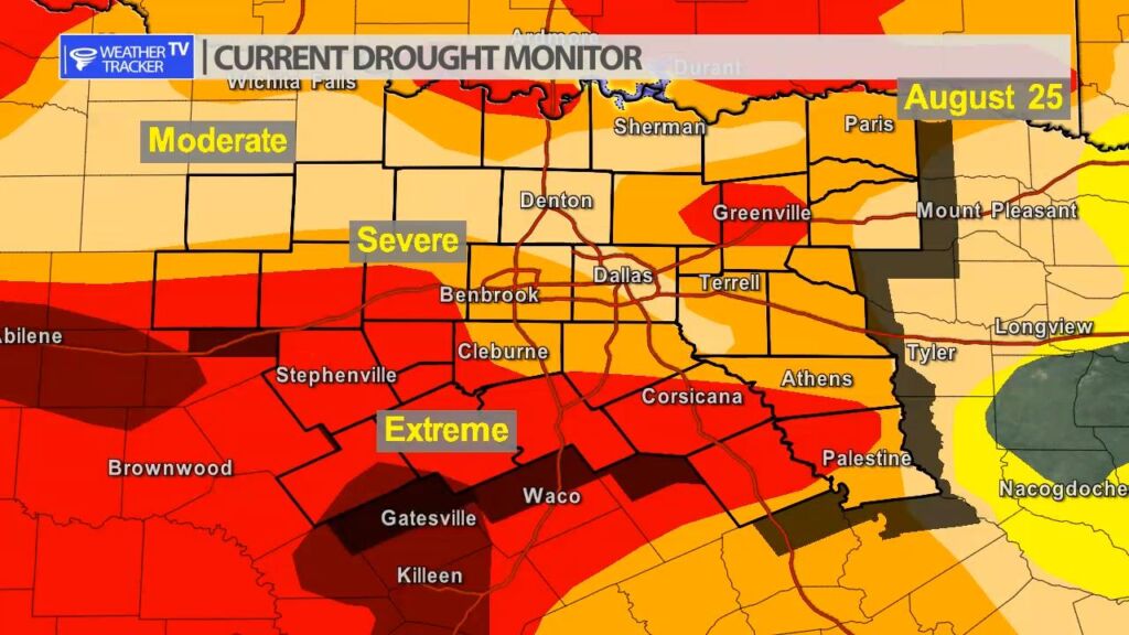
The updated Drought Monitor was released for this week and there was some improvement across North Texas – specifically in Dallas county where we saw the historic rainfall. Other areas still under severe to extreme drought criteria. The good news is that more rain is on the way next and we should continue to put a dent in the drought.


William’s North Texas Hazardous Weather Forecast for Thursday:
No hazardous weather is expected at this time.


DFW today Sunny. Highs in the lower 90s. Northeast winds 5 to 10 mph. -William