Tuesday’s Fire Weather Forecast

Texas Weather Tracker TV Alert

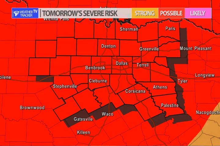
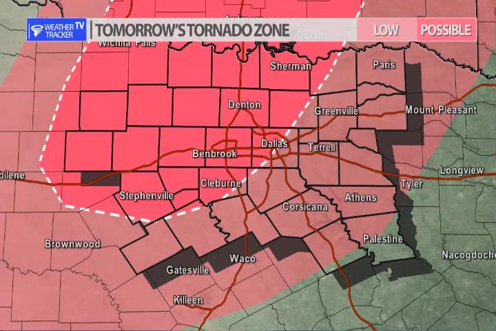
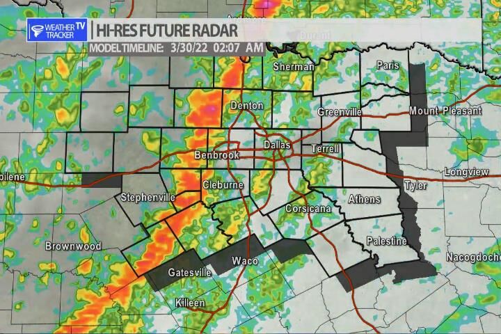
The current Burn Ban Map for Texas is posted above.

ELEVATED FIRE THREAT THIS AFTERNOON AND EARLY EVENING WEST OF I-35/35W

…ELEVATED FIRE THREAT THIS AFTERNOON AND EARLY EVENING WEST OF I-35/35W… WARM AND WINDY CONDITIONS WILL CONTINUE ACROSS WESTERN PARTS OF NORTH AND CENTRAL TEXAS. DESPITE MINIMUM RH VALUES BETWEEN 35 AND 45 PERCENT THIS AFTERNOON ACROSS THESE AREAS, FUELS CONTINUE TO REMAIN VERY DRY WITH VERY HIGH ERC-G VALUES. THESE ANTECEDENT EXTREMELY DRY FUELS SHOULD BE ABLE TO SUPPORT SOME RAPID FIRE SPREAD IN COMBINATION WITH THE VERY GUSTY SOUTH WINDS 20 TO 30 MPH AND DESPITE HUMIDITY LEVELS BEING WELL ABOVE CRITICAL VALUES WEST OF I-35/35W TODAY. EXTREME CARE IS URGED DURING ALL OUTSIDE ACTIVITIES WHERE THERE IS A POTENTIAL FOR GRASS FIRES TO GET STARTED. AVOID OUTSIDE BURNING AND WELDING. DO NOT TOSS LIT CIGARETTE BUTTS OUTSIDE. REPORT WILD FIRES TO THE NEAREST FIRE DEPARTMENT OR LAW ENFORCEMENT OFFICE QUICKLY.

7:11 PM | Wind Advisory until 4:00 AM Wednesday

Texas Weather Tracker TV Alert

From William Cole: A Wind Advisory has been issued in the Weather Tracker TV DFW coverage area from 1:00 PM Tue until 4:00 AM Wednesday for Anderson, Bosque, Collin, Cooke, Dallas, Delta, Denton, Ellis, Erath, Fannin, Freestone, Grayson, Hamilton, Henderson, Hill, Hood, Hopkins, Hunt, Jack, Johnson, Kaufman, Lamar, Montague, Navarro, Palo Pinto, Parker, Rains, Rockwall, Somervell, Stephens, Tarrant, Van Zandt, Wise & Young Counties in North Texas.

South winds 20 to 30 mph with gusts up to 40 mph expected.

Stay with William Cole and Weather Tracker TV Dallas – Fort Worth for continuing coverage, online, on our app and on TV. Let’s stay safe together.

Severe Risk Late Tuesday

Severe risk late Tuesday into early Wednesday.

The risk of severe weather returns to North Texas late on Tuesday into early Wednesday morning. As an upper level storm system approaches from the west. A dryline will set up in the Big Country and by late evening storms will rapidly develop out there. Scattered supercells are possible and the activity will push east into our western counties. The storms will then morph into a line and continue pushing east into the overnight arriving in the Metroplex after 1 am – 2am. When the activity initially develops – hail – larger than golf balls will be a concern but as the storms evolve into a line – gusty winds 65 mph+ will be the primary concern into the overnight. There is a tornado threat. The supercells that initially form in the Big Country may pose a tornado threat as they move into our western counites. After the line of storms form – brief spin up tornadoes remain possible into the overnight. We will have more updates throughout the day and as always severe weather coverage tomorrow as needed.

Tornado Zone
Line of storms approaching the Metroplex after 1 am – early Wednesday morning.