
Current Set Up Across the Nation

DFW today Sunny. Highs in the mid 60s. South winds 10 to 15 mph, increasing to 15 to 20 mph this afternoon. -William

Here’s a look at Local Radar and Live Temperatures across North Texas.
DFW the rest of tonight: Clear. Not as cold with lows in the mid 30s. South winds 5 to 10 mph.


The current Burn Ban Map for Texas is posted above.
ELEVATED FIRE THREAT ALONG AND SOUTHEAST OF SHERMAN-DENISON, TO FORT WORTH, TO MERIDIAN, TO GOLDTHWAITE LINE THIS AFTERNOON AND EARLY EVENING.
…ELEVATED FIRE THREAT ALONG AND SOUTHEAST OF SHERMAN-DENISON, TO FORT WORTH, TO MERIDIAN, TO GOLDTHWAITE LINE THIS AFTERNOON AND EARLY EVENING. WARM, DRY AND WINDY CONDITIONS ALONG WITH ABUNDANT DORMANT AND DRY VEGETATION WILL RESULT IN A ELEVATED THREAT FOR GRASS FIRES THIS AFTERNOON ACROSS EASTERN NORTH TEXAS AND ALL OF CENTRAL TEXAS. SOUTH OR SOUTHWEST WINDS 15 TO 20 MPH WITH A FEW GUSTS IN EXCESS OF 25 MPH ARE POSSIBLE WITH HIGHS IN THE MID TO UPPER 60S AND AFTERNOON HUMIDITY VALUES BOTTOMING OUT BETWEEN 15 AND 25 PERCENT. EXTREME CARE IS URGED DURING ALL OUTSIDE ACTIVITIES WHERE THERE IS A POTENTIAL FOR GRASS FIRES TO GET STARTED. AVOID OUTSIDE BURNING AND WELDING. DO NOT TOSS LIT CIGARETTE BUTTS OUTSIDE. REPORT WILD FIRES TO THE NEAREST FIRE DEPARTMENT OR LAW ENFORCEMENT OFFICE QUICKLY.

William’s North Texas Hazardous Weather Forecast this Evening:
No hazardous weather is expected at this time.
DFW tonight Clear. Not as cold with lows in the mid 30s. South winds 5 to 10 mph. -William


Here’s a look at Live Temperatures across North Texas, Local Radar and the Updated Forecast Map.
DFW today Sunny. Not as cool with highs in the mid 50s. Northwest winds around 5 mph, becoming southwest this afternoon. -William


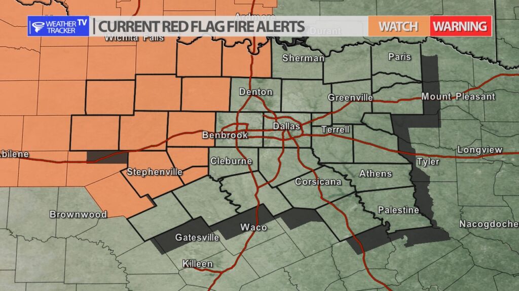
A Fire Weather Watch has been issued for our western counties for Sunday afternoon. South winds may gust over 30 mph and humidity will be exceptionally low –10% – 20%. Along with all of the winter kill and dry vegetation – you have the recipe for fire danger. Any outdoor burning would be discouraged and remember not to throw your cigarette butts out of the window. Any fire that starts would have a rapid spread ability. The fire danger zone is west of the DFW Metroplex.