ALERT 3:43 PM | T-Storm Watch until 10:00 PM Monday

Texas Weather Tracker TV Alert

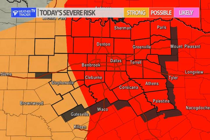
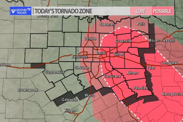
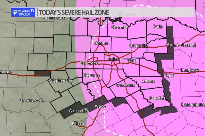
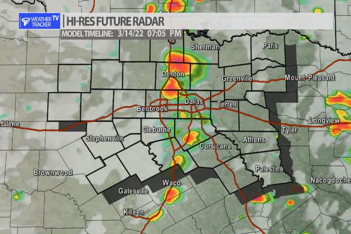
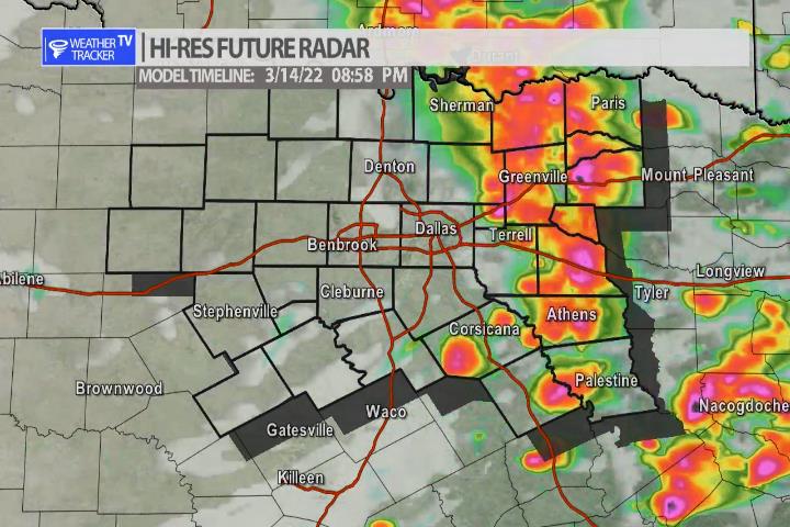
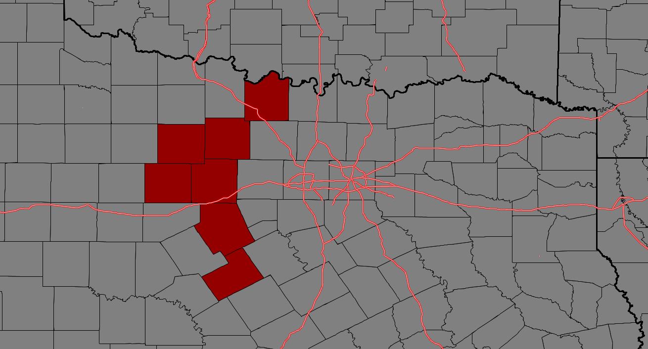
From William Cole: A T-Storm Watch has been issued in the Weather Tracker TV DFW coverage area for the following counties until 10:00 PM Monday. Anderson, Collin, Dallas, Delta, Ellis, Fannin, Freestone, Henderson, Hill, Hopkins, Hunt, Kaufman, Lamar, Navarro, Rains, Rockwall & Van Zandt.

We’ll have Live Severe Weather Coverage on the channel – which includes Texas’ #1 Storm Chasing Team – as needed. Be sure to download our free Weather Tracker TV DFW mobile app and add our Live channel to your Roku, Apple or Amazon Fire TV device.

Stay with William Cole and Weather Tracker TV Dallas – Fort Worth for continuing coverage, online, on our app and on TV. Let’s stay safe together.

DFW Early Monday Afternoon Update

Texas Weather Tracker TV Alert

Here’s a look at Live Temperatures across North Texas, Local Radar and the Updated Forecast Map.

DFW REST OF today Cloudy late this morning, then partly sunny with a 40 percent chance of showers and T-Storms this afternoon. Some T-Storms may be severe. Highs in the lower 70s. South winds 15 to 20 mph with gusts up to 30 mph. -William

Texas Weather Tracker TV Alert

Texas Weather Tracker TV Alert

Severe Weather Possible Later Today

Today’s Severe Risk Map

The risk of severe weather returns to North Texas late this afternoon and evening. As a dryline sets up just west of the I-35 corridor – along with a very dynamic Jetstream storm system approaching – storms will quickly develop over the Metroplex and near I-35. Storms may form as early as 5 pm but it appears as though a broken line of storms should rapidly develop after 6 pm and then push east through the evening. The primary concern is hail up to the size of golf balls and wind gusts over 60 mph. An isolated tornado can’t be ruled out, but tornado probabilities are low today. As always we’ll have updates on our mobile app all afternoon and live severe weather coverage on the channel this evening as needed.

Today’s Tornado Zone – Isolated tornadoes possible.
Today’s Damaging Hail Zone – Hail sizes up to Golf balls possible.
Storms rapidly develop near the I-35 corridor by 6 pm.
A broken line of storms pushes east through the evening.

Today’s North Texas Hazardous Weather Forecast

Texas Weather Tracker TV Alert

William’s North Texas Hazardous Weather Forecast for Monday:

T-Storm chances increase late this afternoon and evening mainly along and east of I-35. A few strong to severe storms are possible. Large hail and damaging winds will be the main threats. There is a low end tornado threat mainly across the far eastern counties.

Monday’s Fire Weather Forecast

Texas Weather Tracker TV Alert

The current Burn Ban Map for Texas is posted above.

AN ELEVATED FIRE THREAT THIS AFTERNOON AND EARLY EVENING ACROSS WESTERN NORTH AND CENTRAL TEXAS

…AN ELEVATED FIRE THREAT THIS AFTERNOON AND EARLY EVENING ACROSS WESTERN NORTH AND CENTRAL TEXAS… WARM, DRY AND BREEZY CONDITIONS ALONG WITH VERY DRY AND DORMANT VEGETATION WILL RESULT IN A ELEVATED THREAT FOR RAPIDLY SPREADING GRASS FIRES THIS AFTERNOON INTO THE EARLY EVENING. AREAS IMPACTED WILL BE GENERALLY ALONG AND SOUTH OF HIGHWAY 380 AND WEST OF I-35/35W. GUSTY SOUTH WINDS THIS MORNING WILL VEER WESTERLY AT 10 TO 20 MPH BEHIND A DRYLINE WITH HIGHS IN THE UPPER 70S AND LOWER 80S EXPECTED. THE GREATEST RISK FOR GRASS FIRES WILL BE ALONG AND WEST OF HIGHWAY 281 FROM THE EASTERN HILL COUNTRY NORTH TO THE EASTERN BIG COUNTRY WHERE AFTERNOON HUMIDITY VALUES WILL FALL TO BETWEEN 15 AND 20 PERCENT. EXTREME CARE IS URGED DURING ALL OUTSIDE ACTIVITIES WHERE THERE IS A POTENTIAL FOR GRASS FIRES TO GET STARTED. AVOID OUTSIDE BURNING AND WELDING. DO NOT TOSS LIT CIGARETTE BUTTS OUTSIDE. REPORT WILD FIRES TO THE NEAREST FIRE DEPARTMENT OR LAW ENFORCEMENT OFFICE QUICKLY.