DFW tonight Mostly clear. Patchy fog after midnight. Lows in the mid 40s. Northeast winds 5 to 10 mph, becoming southeast after midnight. -William

DFW tonight Mostly clear. Patchy fog after midnight. Lows in the mid 40s. Northeast winds 5 to 10 mph, becoming southeast after midnight. -William

Here’s a look at Live Temperatures across North Texas, Local Radar and the Updated Forecast Map.
DFW this afternoon Mostly sunny. Highs in the upper 60s. North winds 10 to 15 mph. -William


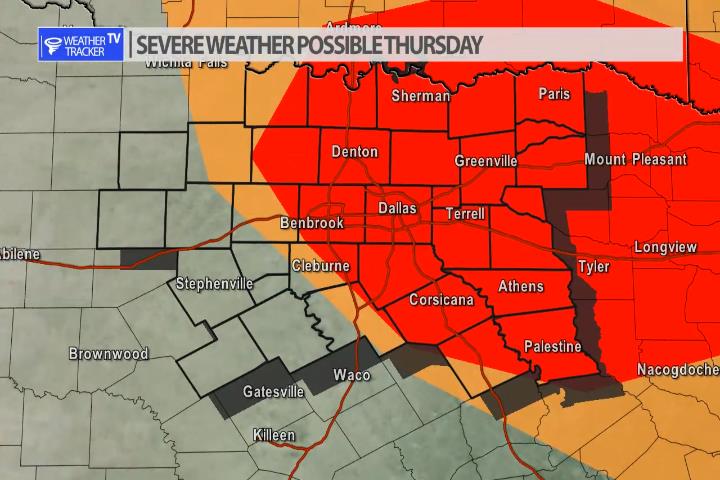
Our next weather maker arrives in North Texas on Thursday and unfortunately it appears severe weather may also be possible. The timing is late afternoon Thursday into the overnight. Scattered storms will develop. Any of the activity could be severe with a quarter to half dollar sized hail threat.
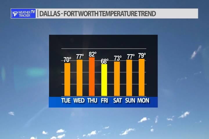
The temperature trend in the Metroplex looks good over the next 7 days with high’s generally in the 70’s. A slight cool down on Friday before we rebound just in time for the weekend.


William’s North Texas Hazardous Weather Forecast for Tuesday:
No hazardous weather is expected at this time.


DFW today Mostly sunny. Highs in the upper 60s. North winds 10 to 15 mph. -William

Here’s a look at Local Radar and Live Temperatures across North Texas.
DFW the rest of tonight: Mostly clear late this evening, then becoming partly cloudy. A 40 percent chance of showers and T-Storms late this evening. Some T-Storms may be severe. Lows in the upper 40s. Northwest winds 10 to 15 mph.
