Severe Weather Update 2:32 PM: Stephens County

Texas Weather Tracker TV Alert

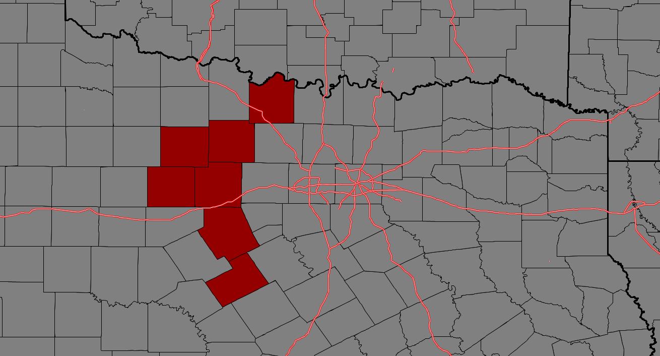
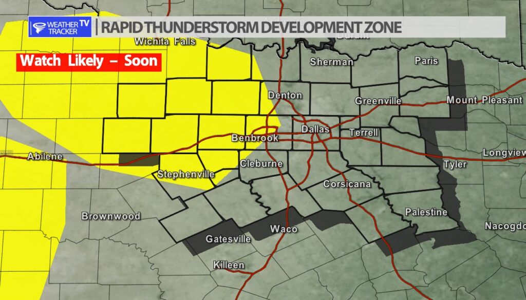
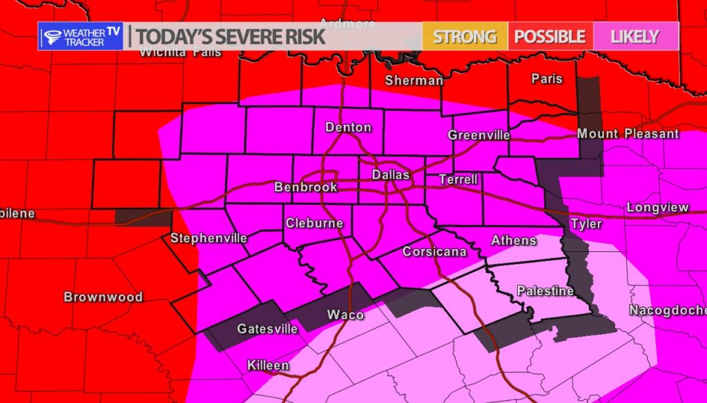
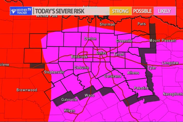
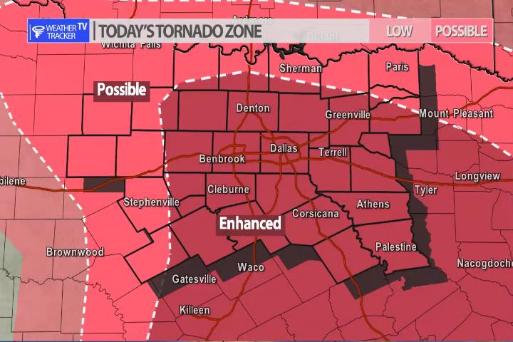
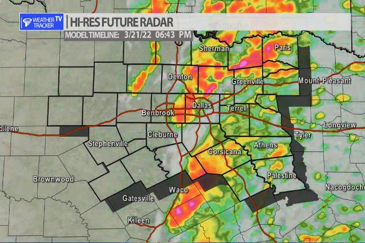
From William Cole: A Severe T-Storm Warning continues for for Stephens County in North TX until 3:15 PM.

At 231 PM , a severe T-Storm was located near Gunsight, or 9 miles north of Cisco, moving northeast at 50 mph.

Primary Threats: 60 Mph Wind Gusts And Quarter Size Hail.

Stay with William Cole and Weather Tracker TV Dallas – Fort Worth for continuing coverage, online, on our app and on TV. Let’s stay safe together.

2:15 PM | T-Storm Warning Stephens County until 3:15 PM Monday

Texas Weather Tracker TV Alert

From William Cole: A Severe T-Storm Warning has been issued in the Weather Tracker TV DFW coverage area for Stephens County in North TX until 3:15 PM.

At 215 PM , a severe T-Storm was located near Cisco, moving northeast at 50 mph.

Hometowns Impacted: Breckenridge, Eastland, Cisco, Necessity, Gunsight, Crystal Falls And I-20 Near The Callahan-Eastland County Line.

Primary Threats: 60 Mph Wind Gusts And Quarter Size Hail.

Stay with William Cole and Weather Tracker TV Dallas – Fort Worth for continuing coverage, online, on our app and on TV. Let’s stay safe together.

ALERT 1:58 PM | T-Storm Watch until 9:00 PM Monday

Texas Weather Tracker TV Alert

From William Cole: A T-Storm Watch has been issued in the Weather Tracker TV DFW coverage area for the following counties until 9:00 PM Monday. Jack, Montague, Palo Pinto, Stephens & Young.

We’ll have Live Severe Weather Coverage on the channel – which includes Texas’ #1 Storm Chasing Team – as needed. Be sure to download our free Weather Tracker TV DFW mobile app and add our Live channel to your Roku, Apple or Amazon Fire TV device.

Stay with William Cole and Weather Tracker TV Dallas – Fort Worth for continuing coverage, online, on our app and on TV. Let’s stay safe together.

DFW Early Monday Afternoon Update

Texas Weather Tracker TV Alert

Here’s a look at Live Temperatures across North Texas, Local Radar and the Updated Forecast Map.

DFW this afternoon Showers and T-Storms. Some T-Storms may be severe. Breezy with highs in the lower 70s. South winds 20 to 25 mph with wind gusts up to 40 mph are possible. Chance of rain near 100 percent. -William

Texas Weather Tracker TV Alert

Texas Weather Tracker TV Alert

MODERATE RISK OF SEVERE WEATHER

Moderate Risk in bright pink.

A rare high end Moderate Risk of severe weather has been issued by the Storm Prediction Center for our far southeastern counties. Large hail and a few tornadoes continues to be the primary concern. A strong or long track tornado may be possible in the moderate area.

SEVERE RISK TODAY

Today’s Severe Risk

The risk of severe weather across North Texas today appears to be increasing. As a warm front lifts north through the area bringing warmer and more unstable air into the area and a strong storm system approaches from the west – the ingredients for severe weather will come together. Scattered showers and T-Storms will be ongoing through most of the afternoon – that is not the main severe concern. The main concern develops after 4 pm with a broken line of supercells. This broken line will pose a threat of large hail – bigger than golf balls possible – damaging winds and a tornado or two. The timeline for the Metroplex is 4 pm to 7 pm – have a severe weather safety plan ready for you, your family and your kids – you know where you will be during that time. Don’t be caught off guard by severe weather. Also, keep in mind your vehicles with the hail threat. We’ll have more on the mobile app through the day and live severe weather coverage as needed on the channel.

Today’s Tornado Zone
Heavy Rain with a localized flooding threat. The flooding threat mainly east.
Scattered showers and T-Storms through the early afternoon.
Broken line of storms forms by 4 pm west of the Metroplex.
Severe weather is possible in the Metroplex from 4 pm – 7 pm as a broken line of storms moves through the area.