Here’s a look at the Monday evening planner for the DFW Metroplex.

Here’s a look at the Monday evening planner for the DFW Metroplex.
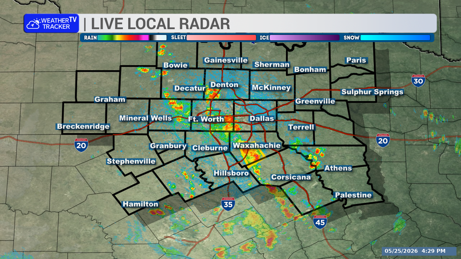
A severe thunderstorm warning is in effect for central Cooke County in North Texas until 5:45 PM. The storm is moving southeast at 25 mph and could produce ping pong ball-sized hail and wind gusts up to 65 mph.
Warned county: Cooke County
**Timing:**
– Until 5:45 PM
– Hubert H. Moss Lake around 5:05 PM
– Gainesville and Lindsay around 5:10 PM
**What to Expect:**
– Ping pong ball-sized hail
– Wind gusts up to 65 mph
– The storm is near Marysville and moving southeast
**Potential Impacts:**
– People and animals outdoors could be injured.
– Hail may damage roofs, siding, windows, and vehicles.
– Strong winds may damage roofs, siding, and trees.
– Other impacted locations include Marysville, Valley View, Woodbine, Bulcher, Myra, Sivells Bend, and Lake Ray Roberts.
– Interstate 35 between mile markers 485 and 503 is included.
**What to Do Now:**
– Get inside a sturdy structure.
– Stay away from windows.
Stay with William Cole and Weather Tracker TV.
Let’s stay safe together.
A few spotty showers or thunderstorms may linger around the Metroplex this evening, mainly before midnight. Rain coverage will be limited, but any storm could bring brief lightning, gusty winds, and a quick downpour. Otherwise, skies turn partly cloudy overnight with lows settling into the lower to middle 70s.
Tuesday looks mostly sunny, hot, and humid, with northeast winds around 5 to 10 mph. Afternoon highs reach the mid-90s across Dallas, Fort Worth, Arlington, Plano, and surrounding communities. Most locations should stay dry.
The heat remains firmly in place through the workweek, with mostly sunny skies and highs generally in the mid-90s. Nights will be warm but manageable, dipping into the lower 70s. A small rain chance returns Sunday and Monday, but widespread or long-lasting rainfall is not expected at this point.
If you have evening plans, keep an eye out for an isolated storm, especially north and east of Dallas.
Stay with William Cole & Weather Tracker TV.
Let’s stay safe together.
Tonight

Overnight – Hourly

Tonight – Precipitation

Tomorrow

Tomorrow – Precipitation

Here’s a look at our Monday evening commute in the DFW Metroplex.

A strong thunderstorm is moving through parts of northeastern Denton and northwestern Collin Counties in North Texas. Gusty winds, small hail, heavy rain, and localized flooding are possible through 9:15 PM.
**Timing:**
– Through 9:15 PM
– Near Prosper and Celina around 8:50 PM
**What to Expect:**
– Wind gusts up to 50 mph
– Hail up to one-half inch in diameter
– Torrential rainfall
**Potential Impacts:**
– Gusty winds could knock down tree limbs and blow around unsecured objects.
– Minor damage to outdoor objects is possible.
– Heavy rain may lead to localized flooding.
**What to Do Now:**
– If outdoors, consider seeking shelter inside a building.
– Do not drive through flooded roadways.
Stay with William Cole and Weather Tracker TV.
Let’s stay safe together.
Strong outflow winds from collapsing thunderstorms are moving south across parts of North Texas. Winds over 40 mph may affect Rockwall, southwestern Hunt, northern Kaufman, southern Collin, and Dallas Counties through 9:00 PM.
**Timing:**
– Through 9:00 PM
– Strong winds are expected near Dallas, Garland, Irving, Mesquite, Carrollton, Richardson, Grapevine, Coppell, Rockwall, and Farmers Branch around 8:25 PM
– Forney and Highland Park around 8:30 PM
– Balch Springs, Dallas Love Field, and DFW International Airport around 8:35 PM
– Terrell around 8:40 PM
**What to Expect:**
– Wind gusts in excess of 40 mph
– The winds are moving south at 20 mph
**Potential Impacts:**
– Tree limbs could be knocked down
– Unsecured outdoor objects could be blown around
**What to Do Now:**
– If you are outdoors, consider moving inside a building
Stay with William Cole and Weather Tracker TV.
Let’s stay safe together.
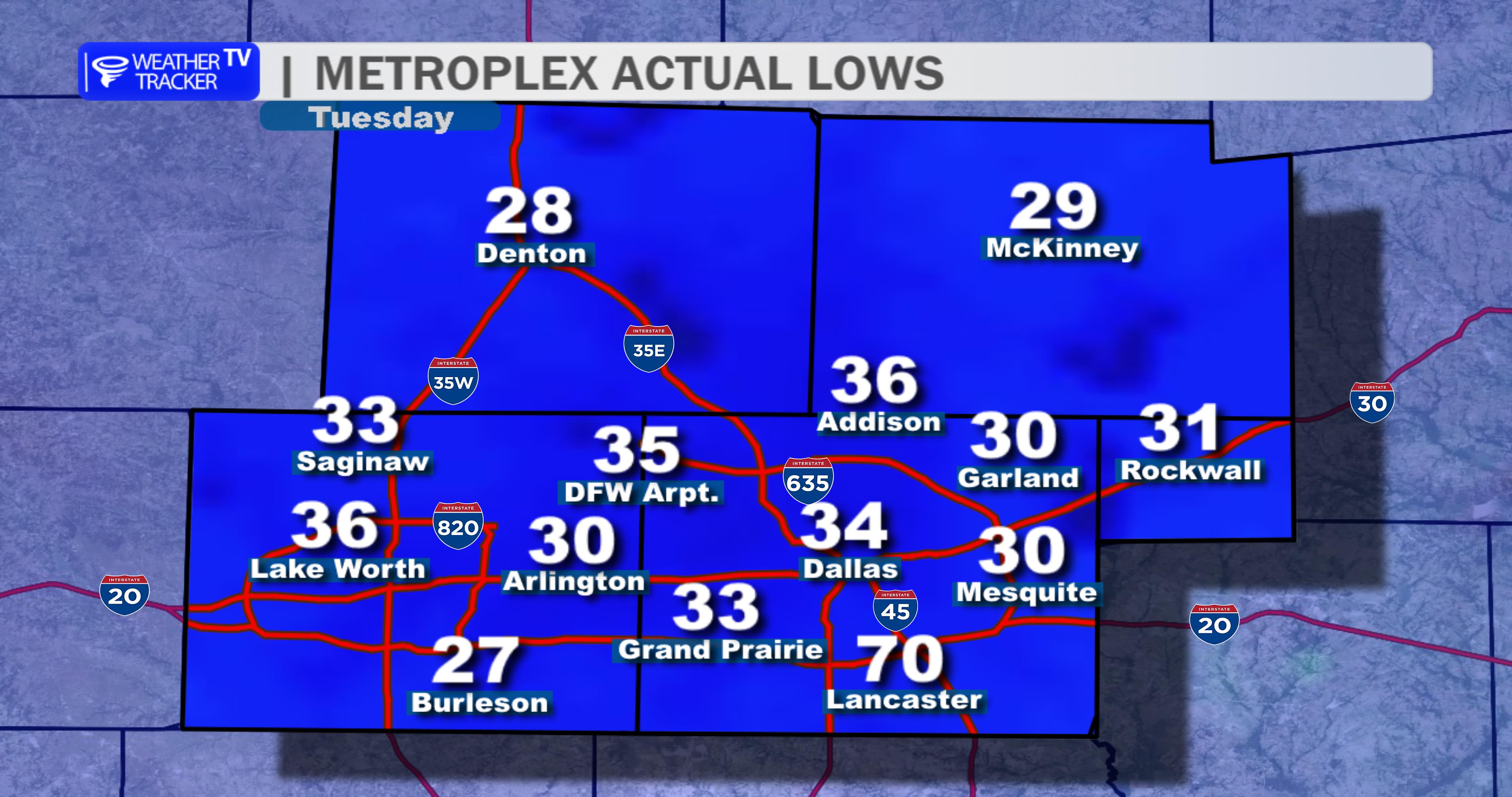
Here is a look at Actual Lows from around North Texas this morning.
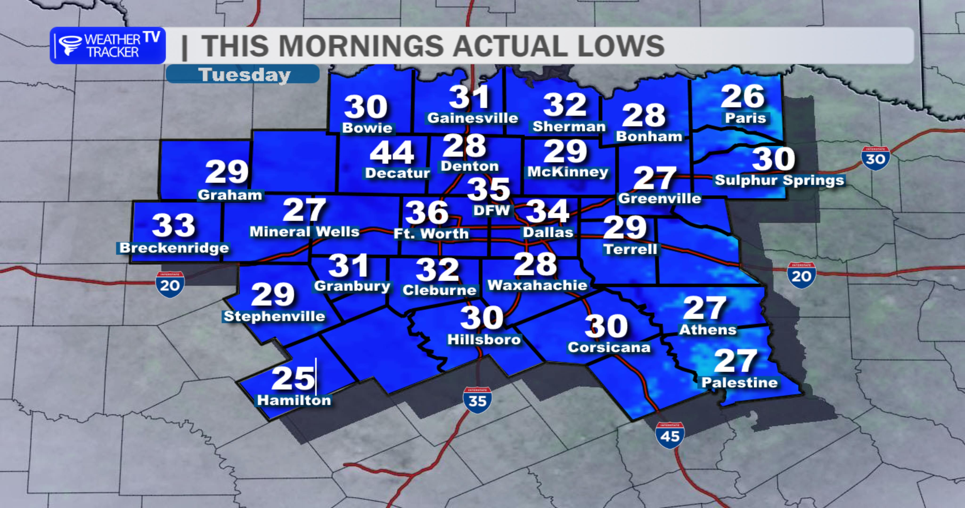
Actual Lows from around the Dallas – Fort Worth Metroplex this morning.
Hot, mostly sunny weather will dominate across Dallas–Fort Worth today, with afternoon temperatures climbing into the mid to upper 90s. A few showers or thunderstorms may pop up late this morning and especially during the afternoon, with rain chances near 30 to 40 percent. Most neighborhoods will stay dry, but any storm could briefly bring lightning, gusty winds, and a quick downpour.
Storms should fade through the evening, leaving partly cloudy to mostly clear skies overnight. Lows settle into the lower to mid 70s.
Tuesday turns mostly sunny and remains hot, with highs generally in the mid 90s and a light northeast breeze. The middle of the week stays mainly dry and warm, before a modest temperature dip toward the lower 90s by Friday.
Plan for heat and keep an eye on the sky this afternoon, especially for outdoor plans.
Stay with William Cole & Weather Tracker TV.
Let’s stay safe together.
Today
Today- Hourly

Today – Precipitation
Tonight

Tomorrow
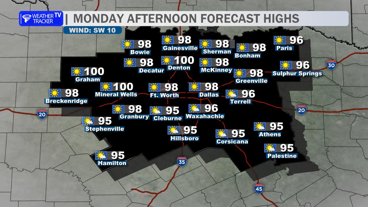
Here’s a look at our Monday morning commute in the DFW Metroplex.
