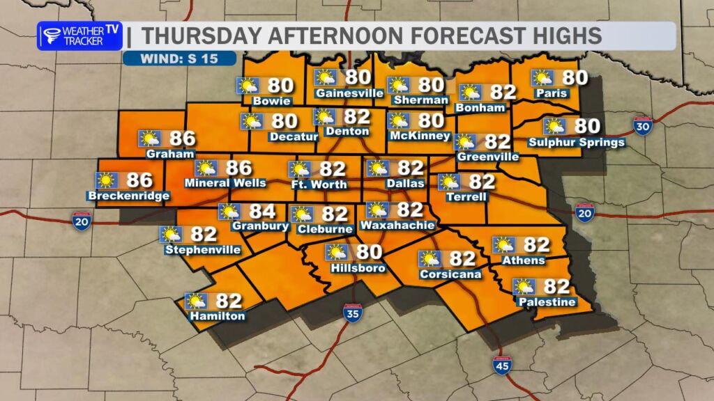
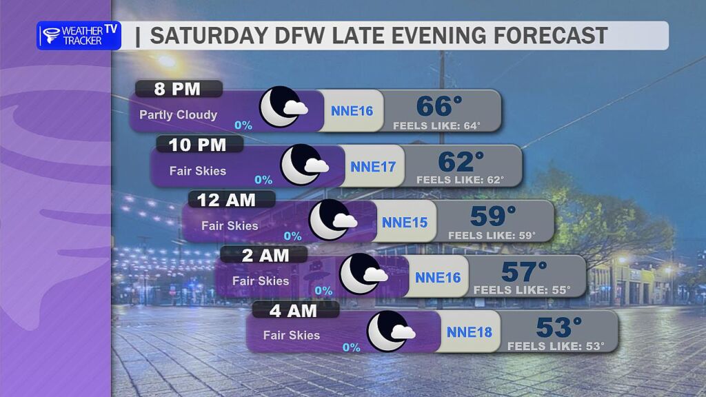
Today’s Forecast (Thursday): Expect another day of above-normal temperatures across North Texas, with highs climbing back into the 80s – a solid 5-10° warmer than seasonal averages for mid-November. South winds will pick up, becoming breezier through the afternoon and evening, gusting 15-25 mph in many areas. These winds will feel warm and humid, carrying moisture from the Gulf, but conditions remain dry with plenty of sunshine.
Friday & Weekend Outlook: The warm-up continues. South winds stay gusty into Friday and linger through the weekend, keeping us in a stable, high-pressure pattern. Highs hold steady in the upper 70s to low 80s each day, with lows in the comfortable 60s overnight. Skies stay mostly clear to partly cloudy—perfect for outdoor plans, early holiday shopping, or yard work.
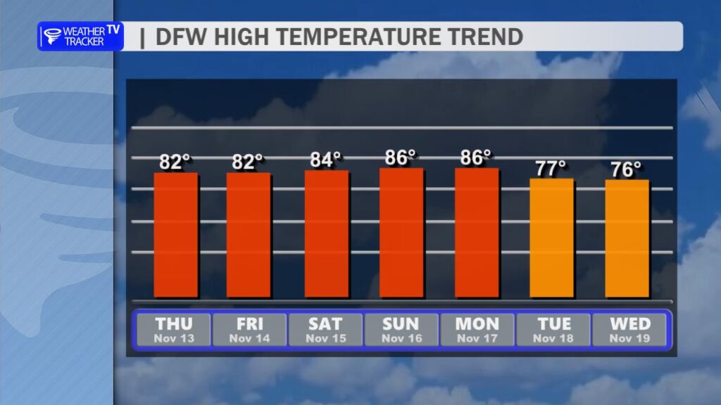
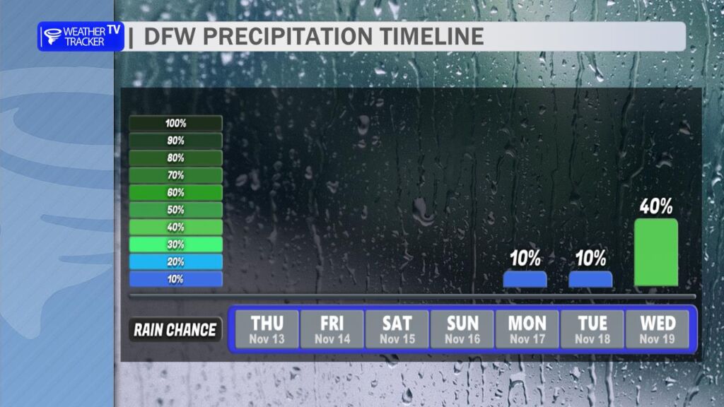
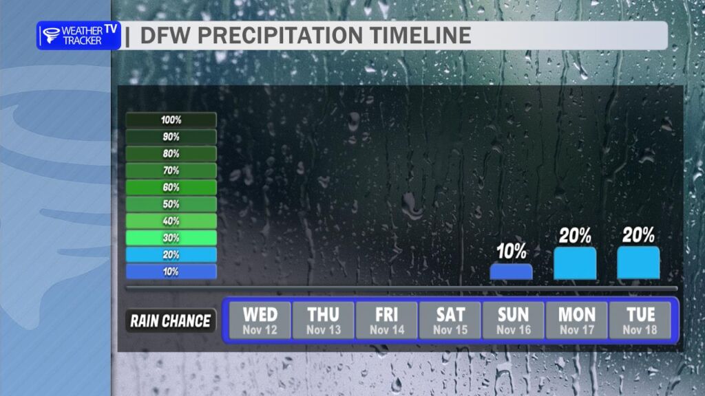
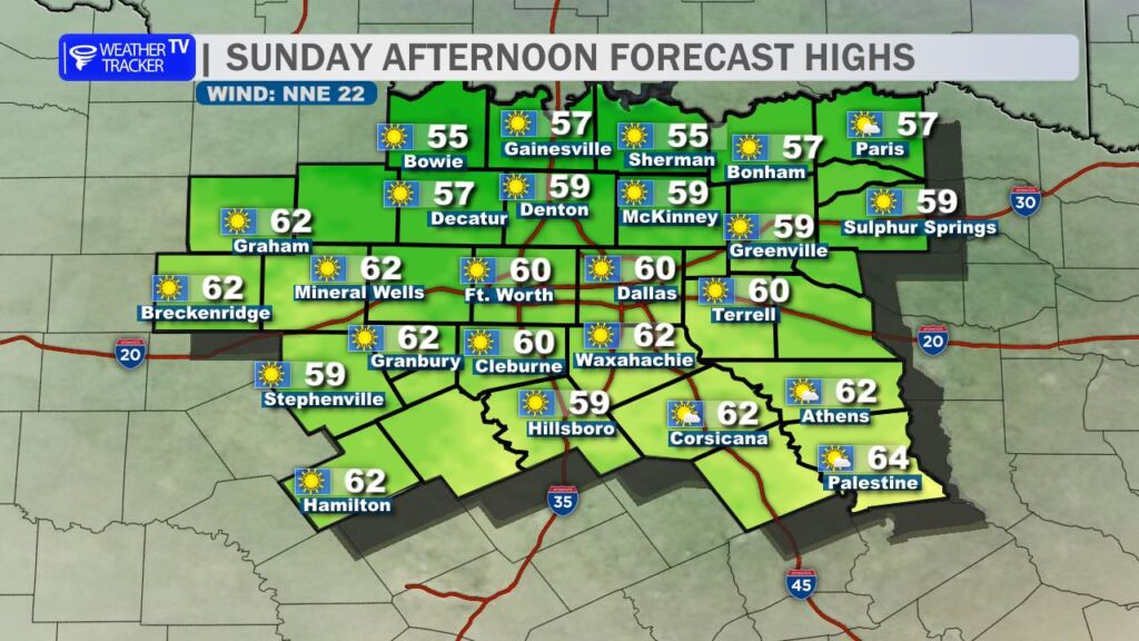
Extended Outlook (Next Week): The pattern shifts by mid-next week (Tuesday-Wednesday), as a frontal boundary approaches from the northwest. This brings our next chance of rain and thunderstorms, with models showing 20-40% odds of scattered showers or storms. Amounts look light (under 0.5 inches), but keep an eye on updates as it nears. Highs cool slightly to the 70s behind any activity.
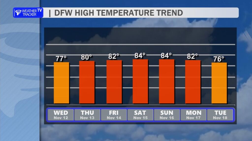
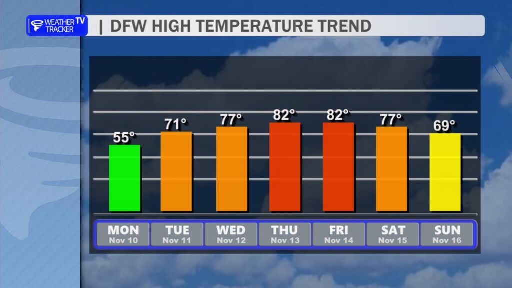
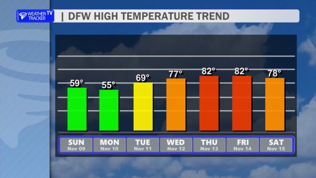
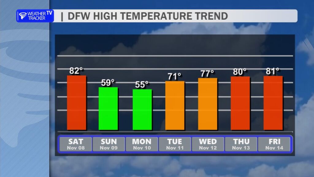
Temperature Rebound Underway After a brief dip into cooler conditions, North Texas is firmly back in a warm pattern this week. High temperatures will climb steadily, reaching the low-to-mid 80s by Thursday and holding there through the weekend. Daytime highs on Thursday and Friday should peak between 80–84° across the Dallas-Fort Worth Metroplex, with suburbs like Denton, Frisco, and Plano seeing similar values. Overnight lows will remain mild, bottoming out in the upper 50s to low 60s.
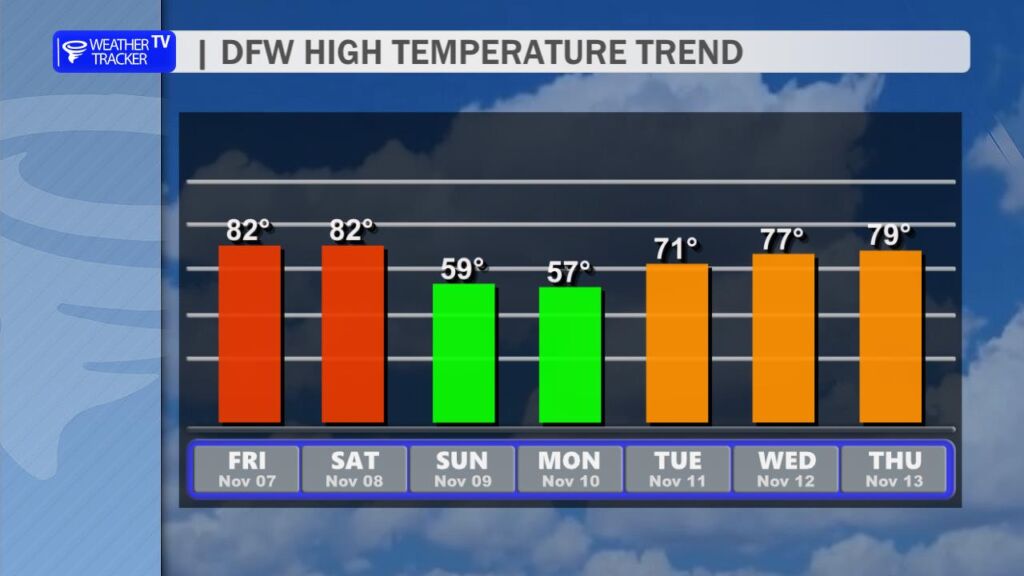
DFW high temperature trend over the next seven days.
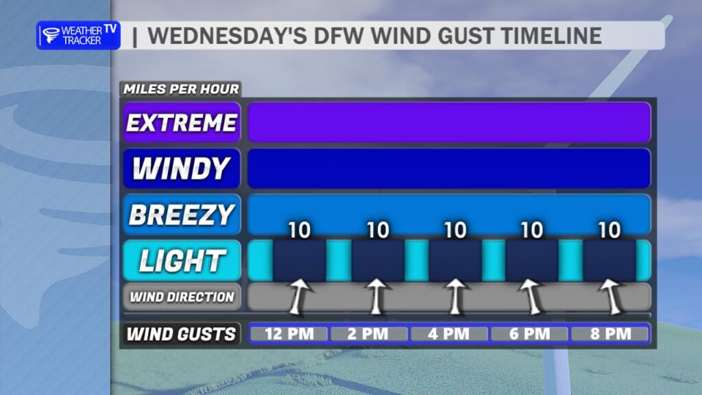
Wind Gusts on the Horizon Today features light and variable winds, with gusts generally below 10 mph. However, a subtle pattern shift begins Thursday as high pressure slides eastward. This will usher in a south-to-southwest breeze by late week, with sustained speeds of 10–15 mph and occasional gusts to 20–25 mph on Friday and Saturday. The returning southerly flow will not only reinforce the warm-up but also import slightly higher humidity, pushing dew points into the mid-60s by the weekend.
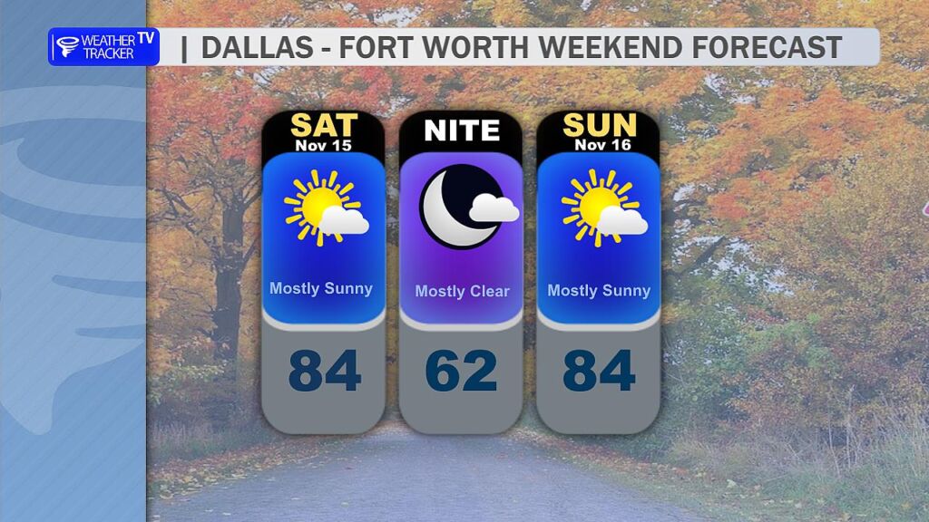
Weekend Forecast: Dry and Warm Initial concerns about weekend rain have evaporated. An upper-level storm system previously progged to bring showers has lifted farther north, tracking across the Central Plains and Upper Midwest instead. As a result, rain chances for Saturday and Sunday have dropped to near zero. Expect mostly sunny to partly cloudy skies, with high temperatures 83–85° both days. The combination of warmth, breezy conditions, and low rain probability makes for ideal outdoor plans.
Next Weather Maker: Tuesday–Wednesday The first legitimate rain chance in over a week arrives early next week. A slow-moving upper-level trough will dig into the Southern Plains, with its associated surface low taking a favorable track across Oklahoma and North Texas. Scattered showers and thunderstorms are likely Tuesday afternoon into Wednesday morning, with the best coverage along and east of I-35. Rainfall totals look modest for now – generally 0.25–0.75 inches across the region – but isolated higher amounts are possible where storms train. Severe weather risk appears low at this range, though a few stronger cells could produce gusty winds and small hail Tuesday evening.
To every veteran and active-duty service member in the DFW Metroplex and beyond – thank you. Your courage, sacrifice, and dedication keep our nation strong. Today, we honor you with gratitude that words alone can’t fully express.
Whether you’re marching in a parade, attending a ceremony, or simply spending the day with family, here’s what North Texas weather has in store.
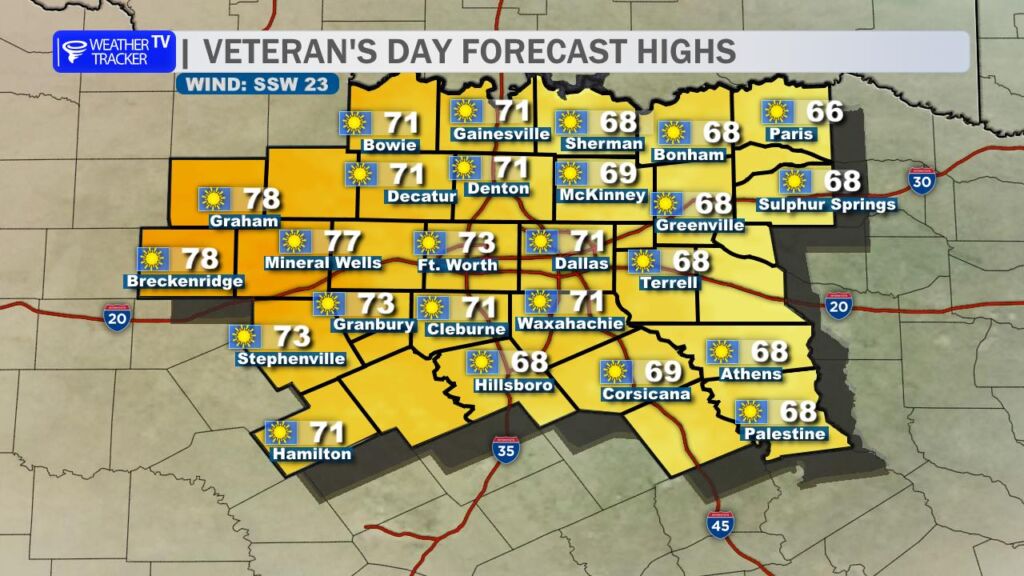
🌞 Today’s Forecast (Tuesday, Nov 11)
High: 71° (DFW Metroplex) Conditions: Sunny, dry, and seasonably mild Winds: South-southwest 15–25 mph, gusts up to 30 mph Humidity: Very low (20–30%)
Bottom Line: A gorgeous fall day for Veteran’s Day events. Just secure loose items (flags, tents, chairs).
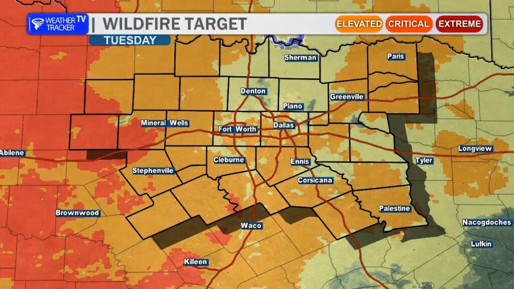
🔥 Elevated Fire Danger Today
Peak gusts near 30 mph + low humidity = high wildfire risk
Outdoor burning is strongly discouraged across all of North Texas
Avoid sparks: no open flames, discard cigarettes properly, and park vehicles away from dry grass
Counties under heightened concern: Dallas, Tarrant, Collin, Denton, Parker, Wise, and points west toward the Big Country.
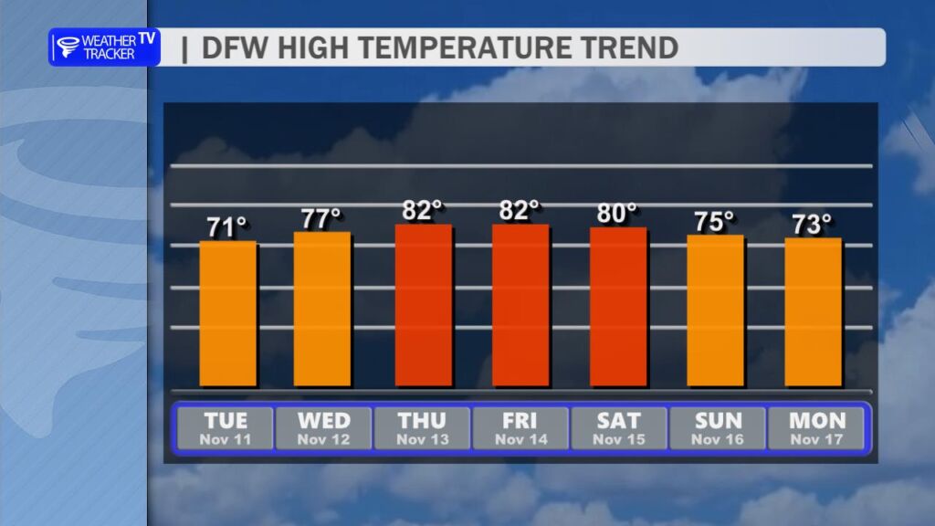
📈 Rest of the Work Week: Warming Trend Ahead
Day
High
Low
Conditions
Notes
Wed
77°
50°
Mostly sunny
Light wind
Thu
82°
57°
Sunny, warmer
Feels like early fall
Fri
82°
62°
Partly cloudy
Warmth Continues
A slow-moving ridge of high pressure will dominate, pushing temps 5–10° above normal by late week.
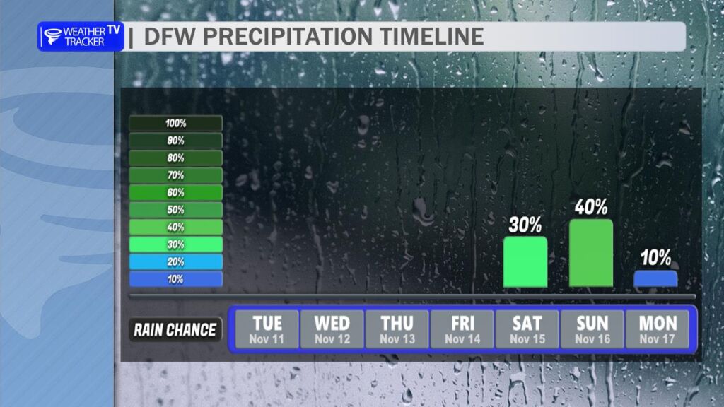
🌧️ Weekend Storm System: Rain Chances Returning
Confidence: Moderate (timing/track still uncertain) Potential Impacts:
Scattered showers/storms possible Saturday night into Sunday
Rain totals: 0.25″–0.75″ (locally higher north/east of DFW)
Severe threat: Low, but gusty winds possible in stronger cells
Cooler air follows: Highs drop back into the 70s early next week
Timeline Jiggle Alert: Models do not agree on the storm’s speed and track. So the forecast will continue to change some as we get closer to the weekend.
Earlier arrival (Sat afternoon): More widespread rain
Later arrival (Sun Evening): Drier Saturday, wet Sunday Late
🎖️ Parade & Event Weather Highlights
Dallas Veterans Day Parade (Downtown): Sunny, near 60 at 11 AM, winds gusting 25–30 mph
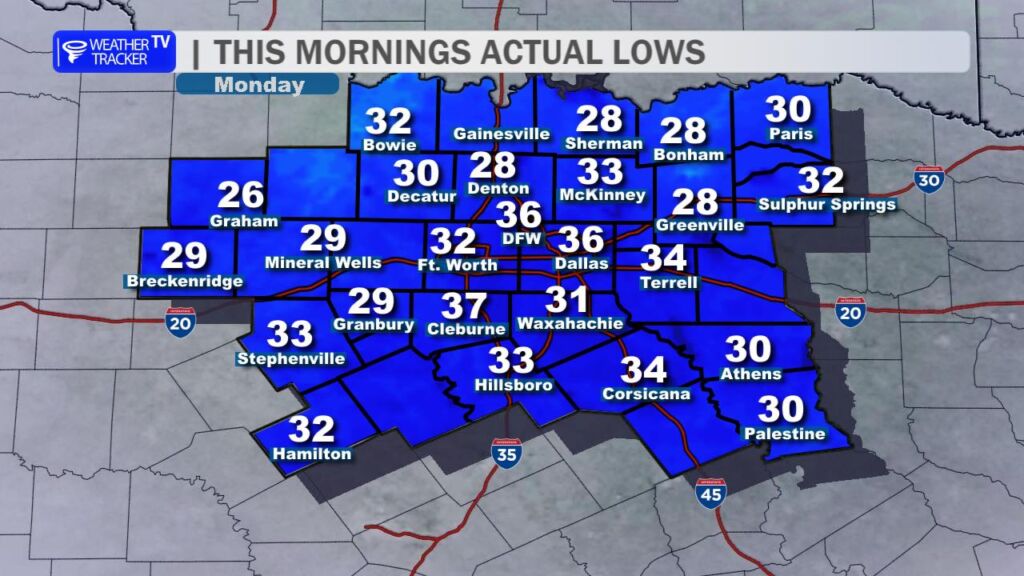
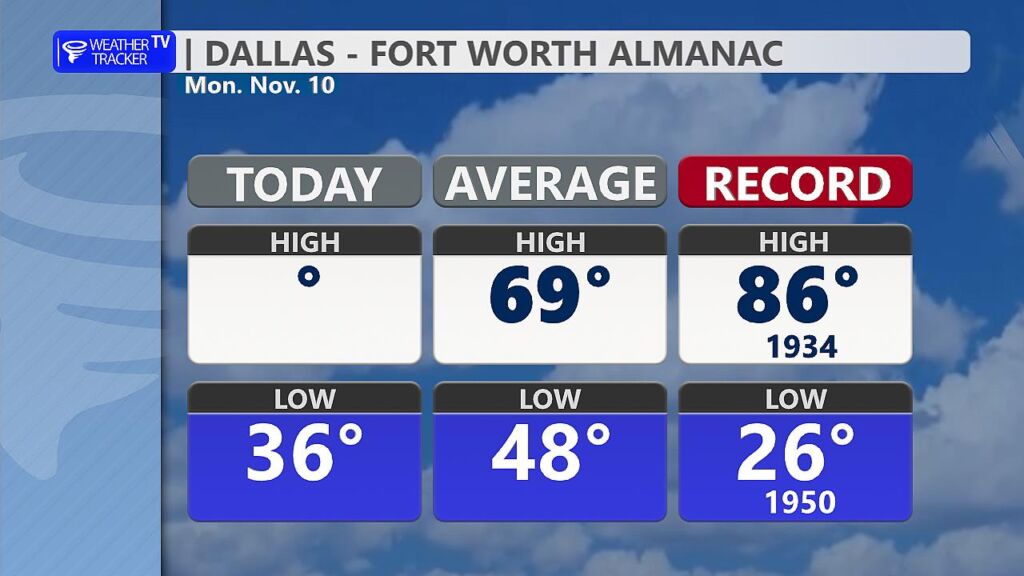
This Morning’s First Freeze Parts of North Texas woke up to their official first freeze of the season. Dozens of locations around North Texas dipped to 32 ° or lower, with several more rural spots in the upper 20s. At DFW Airport, the thermometer bottomed out at 36 ° just before sunrise – marking the coldest reading since early April. Patchy frost was widespread on car windshields, rooftops, and grassy areas, especially where the wind went calm overnight.
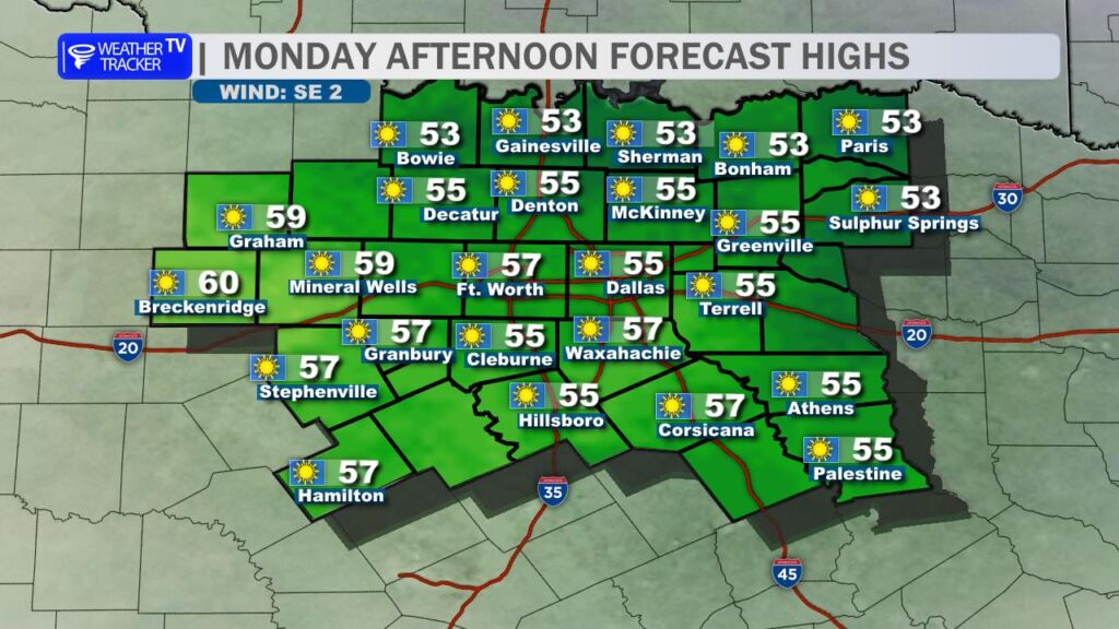
Today’s Chilly but Sunny Afternoon High pressure is firmly in control, delivering wall-to-wall sunshine and crystal-clear skies. Despite the abundant November sun, temperatures are struggling to climb. Expect afternoon highs only in the mid-to-upper 50s across most of the region – about 10–12 ° below average for this date. Light northerly breezes will make it feel a few degrees cooler in open areas.
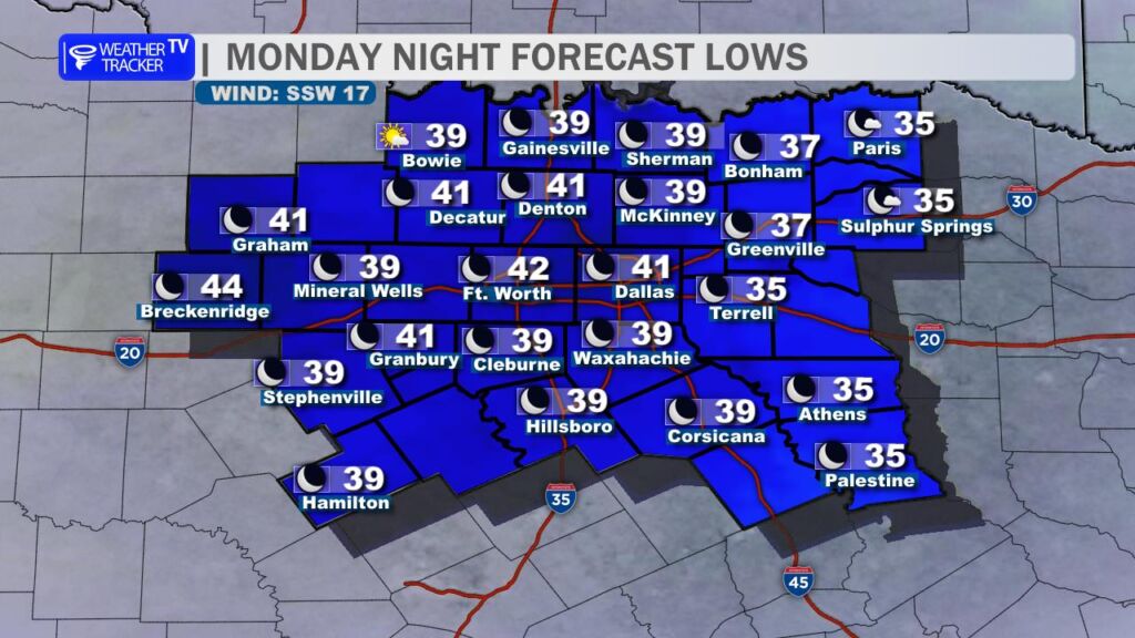
Tonight: Not Quite as Cold Clear skies and light winds continue overnight, but a slightly milder air-mass will keep lows mainly in the upper 30s to low 40s in the Metroplex (mid-30s possible in the typical cold spots northwest of Fort Worth). Frost should be much less widespread than this morning.
Tuesday: Windy Warm-Up Begins A strong southwesterly flow develops ahead of an approaching trough, pumping warmer air back into Texas. Highs rebound into the low-to-mid 70s, but gusty winds 20–35 mph will make it feel spring-like despite the calendar saying November. Elevated to near-critical fire weather conditions are likely west of I-35 where relative humidity drops into the 20–30 % range and dry grasses remain abundant. Outdoor burning is strongly discouraged from late morning through sunset.
Wednesday–Friday: Summer Encore The warm sector deepens, with high temperatures pushing well into the 80s both Thursday and Friday – potentially flirting with near records. Morning lows will only drop into the 60s by Thursday night. Enjoy it while it lasts – this will feel more like early October than mid-November.
Weekend: Rain Chances on the Rise A potent upper-level trough and associated cold front are progged to swing through Saturday night into Sunday. Forecast confidence is increasing for widespread showers and embedded thunderstorms, with some models hinting at 1–2 inches of rain across North Texas. Severe potential appears low for now, but a few strong storms can’t be ruled out along the front. Much cooler air spills in behind the system for early next week – highs likely back in the 60s to start next week.
Bottom Line Bundle up one more time today, then get ready for a dramatic warm-up that’ll have you reaching for short sleeves by midweek. Keep the umbrella handy for the weekend – our next decent rain chance in quite a while looks to finally materialize.
Brr! The First Real Taste of Fall Has Officially Crashed the Party in North Texas!
Grab the coats, scarves, and hot cocoa, folks – the season’s first strong cold front has roared into North Texas overnight, and will deliver our first widespread freeze of the fall tonight. This isn’t just a little chill… this is legit winter-preview weather.
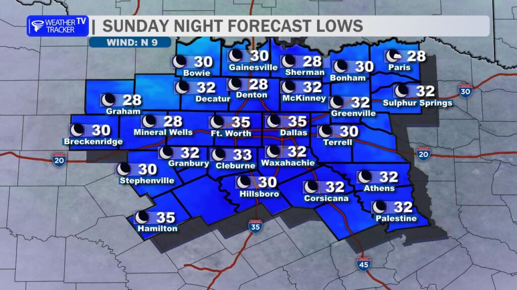
Today (Sunday): Highs will struggle to climb out of the 50s – think 56–59° across the Metroplex. Skies stay mostly sunny, but that brisk northerly wind will make it feel more like the mid-40s at times. Bundle up if you’re heading to church, or any plans that take your outdoors.
Tonight into Monday Morning: Temperatures plummet overnight. Widespread lows in the upper 20s to mid-30s are expected across North Texas.
Dallas–Fort Worth: Hovering right around 31–35° by sunrise Monday.
North & west of DFW (Decatur, Gainesville, Sherman): Mid to upper 20s – definite hard freeze territory.
South & east (Waxahachie, Corsicana, Athens): Low 30s generally – still cold enough for a freeze.
Yes, it’s officially “3 P’s” time:
People – Check on elderly neighbors, relatives, or anyone who might need help staying warm.
Pets – Bring outdoor pets inside if possible. If they must stay out, make sure they have a dry, insulated shelter and unfrozen water.
Pipes – Not quite pipe-bursting cold (we’re looking at you, February 2021), but still smart to drip faucets on the north side of the house and open cabinet doors under sinks.
The Good News? This cold snap is a quick hitter. A warming trend kicks in starting Tuesday. By mid-to-late week, we’re back into the 80s for highs – classic Texas weather whiplash.
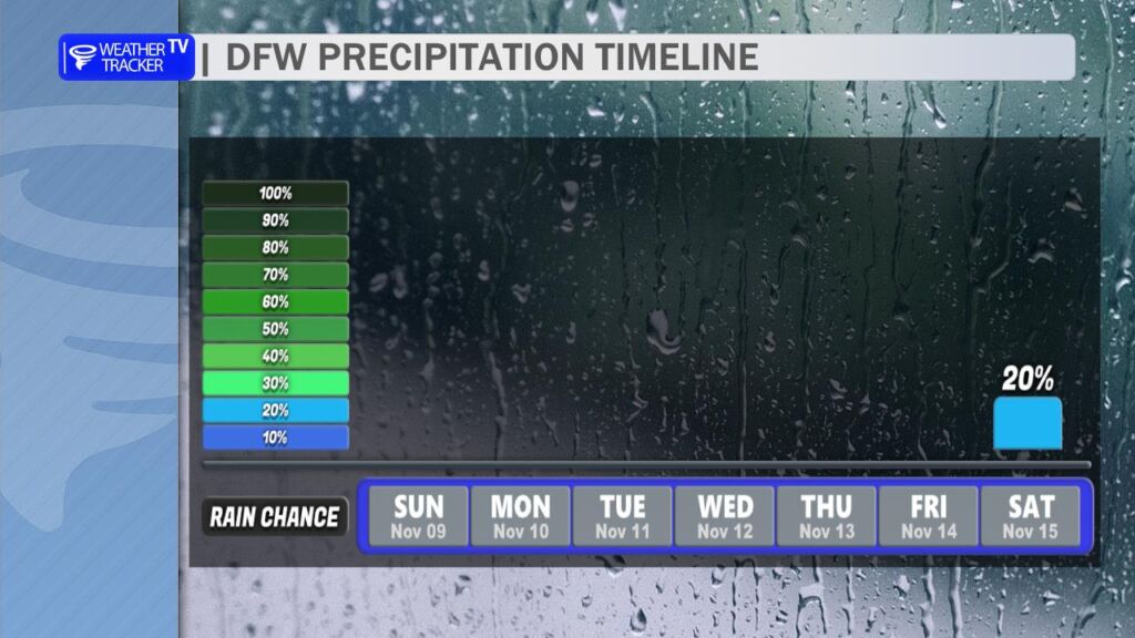
Looking Ahead: The forecast stays bone dry through the upcoming work week – no rain in sight. But there are growing signals for a stormy pattern change next weekend. An upper-level storm system could bring rain chances back to North Texas next Sunday into Monday (Nov 16–17). Still early, but something to watch for now.
So enjoy the crisp fall air while it lasts, North Texas – winter is just flexing a little before Thanksgiving. Stay warm out there. ❄️🍂
If you’re a fan of shorts and sunshine, get outside this afternoon and soak it up, because Mother Nature is about to slam the door on summer-like weather. A powerful Fall cold front – the strongest of the season so far – barrels into North Texas this evening, ushering in the coldest air we’ve seen since last February. For many, this means the first freeze of the season is on deck.
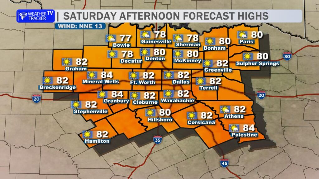
Saturday (Today): The DFW Metroplex enjoys one last taste of early-fall warmth. Highs climb into the lower 80s under a mix of sun and high clouds. It’ll feel downright pleasant – perfect for football watch parties, yard work, or a late-season patio lunch. But don’t get too comfortable.
Tonight – The Switch Flips: The cold front crashes through between 6 PM and 10 PM. As it passes, winds whip around to the north at 15-25 mph with gusts over 35 mph. Temperatures will plummet 20° in just a few hours. By midnight, many areas will drop from the 70s into the 50s. Heads up if you’re making plans to be out late.
Sunday: Wake up to a completely different weather. Chilly and blustery – highs struggle to reach 60° across the Metroplex, with wind chills in the 40s most of the day. North winds keep jackets zipped and leaves flying. It’ll feel more like December than early November.
Monday Morning – First Freeze Alert: Widespread frost is a lock, but a hard freeze (28° or lower for several hours) is likely across most of North Texas, including the western and northern DFW suburbs (Denton, McKinney, Little Elm, Frisco, Plano, etc.). Even the urban core of Dallas-Fort Worth will flirt with 32° before sunrise. Protect sensitive plants, pets, and pipes! Lows range from 28° in the colder spots to 33-35° inside the Metroplex.
Monday Afternoon: Still chilly – highs only in the mid-50s under plenty of sunshine. It’ll be a crisp, beautiful Fall day, but you’ll need layers.
Next Week – The Rebound: Good news: the chill doesn’t last forever. A warming trend kicks in Tuesday and accelerates through the week. By Wednesday and Thursday, highs return to the 70s, with lower 80s possible again by next weekend – right back above normal for mid-November.
Rain Chances Returning? The extended models are finally hinting at a pattern shift. After weeks of dry conditions, decent rain chances could return by late next weekend (Nov 15-16) as a storm system approaches from the west. It’s still a ways out, but the dry ground might finally get some relief.
Bottom Line: Get ready for a classic North Texas temperature roller coaster. Fall is officially here… and it brought its cold-weather friends. ❄️🍂
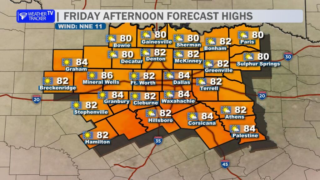
Happy Friday, North Texas! We’re wrapping up the work week with yet another delightfully warm afternoon across the Dallas-Fort Worth Metroplex. Highs this afternoon will climb into the low 80s under mostly sunny skies – perfect weather for a quick walk around White Rock Lake.
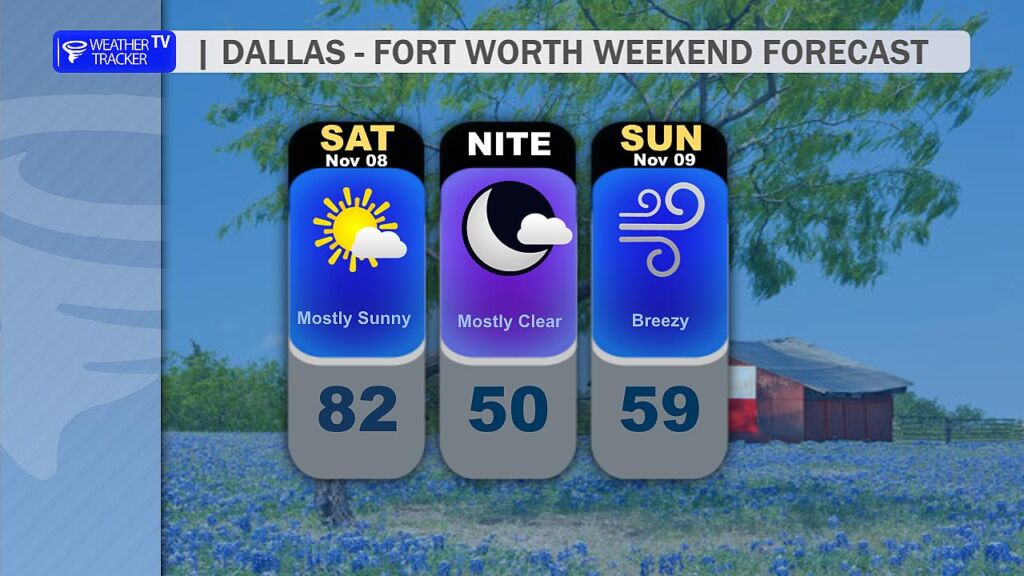
Saturday: One Last Taste of Early Fall Warmth The warmth hangs on for one more day. Look for morning lows in the upper 50s, followed by afternoon highs pushing the lower 80s – about 15–20 degrees above normal for early November. Skies stay mostly sunny to partly cloudy.
Saturday Night – Sunday: Strong Cold Front Charges In A strong Fall cold front will blast through between 8 PM and midnight Saturday. Winds will crank up out of the north at 20–30 mph with gusts over 40 mph possible, especially west of I-35. Temperatures will plummet 20–25 degrees in just a few hours behind the front. By sunrise Sunday, we’ll be waking up to blustery 40s with wind chills in the 30s. Sunday’s highs struggle into the 50s despite plenty of sunshine. Bundle up for church, or any plans that take you outdoors – big coats will finally feel appropriate.
Monday Morning: First Freeze of the Season on Deck The core of the cold air settles in Sunday night into Monday morning. Widespread lows in the 29–34° range are likely across North Texas, with outlying areas west and north of DFW (Decatur, Gainesville, McKinney, Waxahachie) dipping to the 32° mark. That’s enough for a light freeze and the first widespread killing frost of the season. If you haven’t protected tender plants, Saturday afternoon is your last warm window to do it. Pipes in unheated garages or crawl spaces may also need a little attention.
The Dry Story Continues Unfortunately, this front is all wind and cold – no rain. Moisture stays locked up, and high pressure builds in behind the front, keeping us in a dry pattern. The latest weather charts show zero meaningful rain chances through at least November 17th. Lawn watering and wildfire concerns will remain elevated.
Quick Glance Summary
Friday: Sunny & warm
Saturday: Warm & breezy, front arrives after dark
Sunday: Blustery & much colder
Monday AM: Widespread freeze likely
Next week: Cool mornings, warmer afternoons, bone-dry
Enjoy the bonus summer-like weekend day tomorrow, North Texas – because starting Saturday night, Fall is hitting the gas pedal! Bundle up, protect those plants, and savor the first real sweater weather of the season.
Another Toasty Day Before a Strong Cold Front Saturday
Good morning, North Texas! If you’ve been loving this November “second summer,” soak it up today because big changes are coming.
Today (Thursday, Nov 6) Expect another gorgeously warm afternoon with wall-to-wall sunshine and a gusty south breeze 15-25 mph (higher gusts near 30 mph west of I-35). Highs will climb into the upper 70s to low 80s—about 15° above normal for early November. Perfect weather for lunch outside, a round of golf, or getting the Christmas lights up early (we see you!).
Friday The warmth hangs on. Slightly less wind, but still running 10-12° above average with highs 78-82°. Cloud cover begins trickling in late.
Saturday – The Main Event A powerful Fall cold front – the strongest of the season so far – arrives between 6 PM and midnight.
Temperatures crash 20-25° in about 6 hours behind the front
North winds gusting 30-40 mph Saturday night
Wind chills drop into the 20s by sunrise Sunday
Sunday & Monday – Welcome to Real November Highs only in the 50’s both days—that’s 10-15° below normal. Overnight lows Sunday night into Monday morning plunge into the 30s across the entire DFW Metroplex and North Texas.
First Freeze Alert Widespread first freeze of the 2025-26 season now looks locked in for Monday morning (Nov 10).
Even typically warmer urban spots like downtown Dallas and Fort Worth should scrape the mid 30’s. If you haven’t protected pipes or brought in the plants yet… this is your warning.
Rain Chances? Unfortunately, this front is bone-dry. Moisture gets shunted well east, so no rain is expected with the passage. The drought continues.
Bottom line: Enjoy 80’s, because by Monday morning you’ll be digging out the heavy coats and scraping frost off the windshield. This is the real deal – the chilliest air since February 2025 is on the way. 🌡️❄️
North Texas can expect another day of unseasonably warm and dry conditions as high pressure remains firmly in control of the region’s weather. Afternoon highs will climb into the low 80s across the Dallas-Fort Worth Metroplex.
Weak Front Stalls North of the Red River
A subtle disturbance sliding across the Southern Plains will nudge a weak cold front southward through Oklahoma this afternoon. However, this boundary will lose momentum and stall along the Red River by evening, never crossing into Texas. As a result, North Texas stays on the warm side of the front, with only a slight increase in high-level clouds possible late in the day. Winds will be noticeably lighter than yesterday; sustained speeds of 5-15 mph with occasional gusts to 20 mph out of the south-southeast.
Reduced Fire Danger in the Big Country
That reduction in wind, combined with slightly higher afternoon humidity west of I-35, will ease elevated fire-weather concerns across the Big Country. While cured grasses and low fuel moisture remain a risk, the combination of lighter winds and a brief uptick in relative humidity will keep the fire danger from reaching the elevated levels seen yesterday. Fire managers still urge caution with any outdoor burning or activities that could spark a wildfire.
Stronger cold front arrives Saturday.Forecast remains dry.
Cold Front #1 Friday
The next notable change arrives Friday afternoon when a weak boundary slips in from the northwest. This shallow cold front will cross the Red River around midday and push through DFW by late afternoon, accompanied by a wind shift to the north at 10–15 mph. Temperatures Friday will top out in the low 80s before the front passes, then hold in the 70s through the evening. Importantly, this front will be moisture-starved; no rain is expected, and skies will remain mostly clear.
Saturday’s Stronger Cold Front
The main event comes Saturday as a much stronger cold front – backed by a vigorous upper-level trough digging across the Central Plains – sweeps through the region. The front is forecast to cross DFW later in the afternoon, bringing a sharp wind shift to the north-northwest with gusts of 25–35 mph. Overnight lows by Sunday night will dip into the mid-to-upper 30s, flirting with the first widespread freeze of the season for locations north and west of I-35. Like Friday’s front, Saturday’s system will also pass dry – no measurable precipitation is anticipated, though a few high-based showers can’t be entirely ruled out along the immediate front in far northeastern Texas.
Sharp cooldown noticeable by Sunday.Frost and freeze for some Sunday night.
A stubborn upper-level ridge anchored over the Southern Plains continues to dominate North Texas weather, suppressing cloud cover and precipitation while allowing daytime highs to climb well above seasonal norms. This ridge is reinforced by a downstream trough over the eastern U.S., creating a classic “omega block” that locks in the mild, dry conditions.
Today (Tuesday): Mostly sunny with highs 78-82° across the Metroplex (DFW airport likely 78°).
Wednesday–Friday: The ridge amplifies slightly, pushing highs into the low to mid 80s. Overnight lows will struggle to dip below 60°F in urban areas.
DFW Temperature Trend
Weekend Cold Front: Sharp but Dry Transition
A vigorous shortwave trough digging into the Central Rockies late Friday will eject a surface cold front across North Texas Saturday night into early Sunday.
Timing: Frontal passage between 10 PM Saturday and 4 AM Sunday (earliest in the northwest Metroplex, latest near Waco).
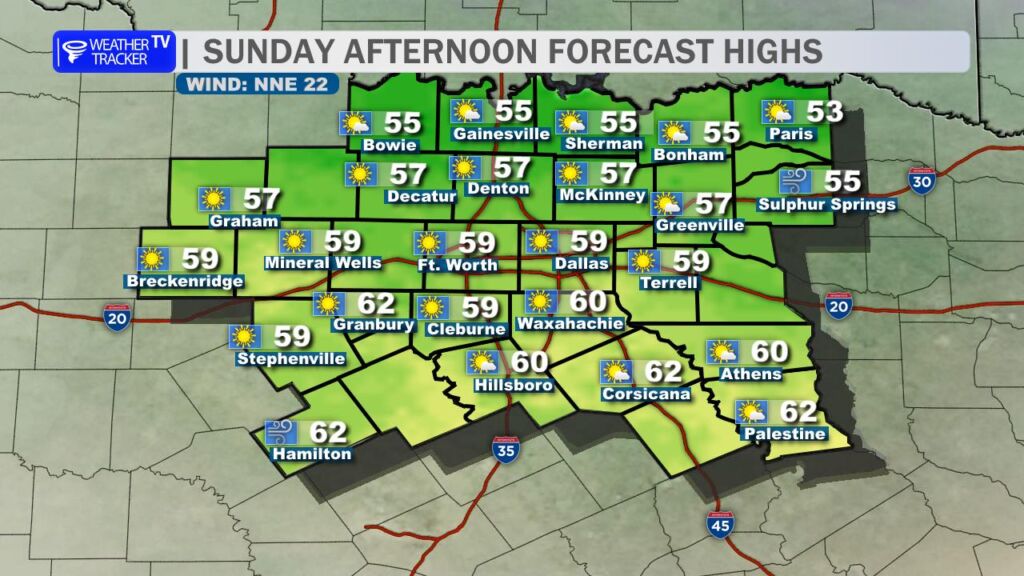
Temperature Drop: Highs Saturday still reach 80–83°, but Sunday highs plummet to the low to mid 60s behind the front. Overnight lows Sunday night dip into the upper 30s northwest to mid-40s southeast.
Wind Shift: Gusty north winds 20–30 mph Sunday will usher in the cooler airmass. Wind chills Sunday morning may briefly drop into the 30s.
Precipitation: The front will be bone-dry. Models show zero QPF across the region as Gulf of America and Pacific moisture remain locked up.
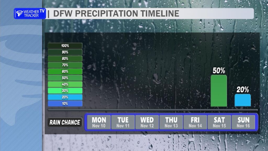
DFW Precipitation Probabilities
Extended Dry Pattern (Days 6–10)
The upper ridge re-builds early next week, but a series of weak troughs will keep temperatures closer to seasonal levels (highs 68–78°F, lows 45–55°F).
Rain Chances: Near zero through at least November 14. The Climate Prediction Center 8–14 day outlook keeps North Texas in the driest quartile for precipitation. Soil moisture continues to decline, with Keetch-Byram Drought Index values climbing above 600 in parts of the Big Country (west of Fort Worth).
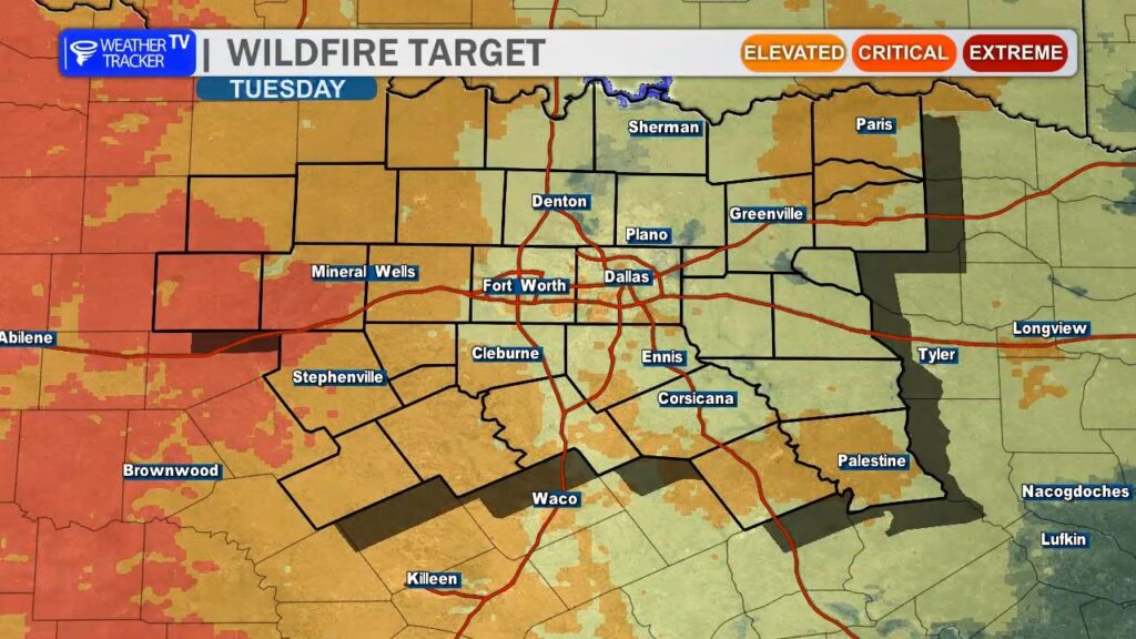
Fire Danger (Today): South winds 15–25 mph with gusts to 30 mph west of I-35 will combine with relative humidity values dropping to 25–30% this afternoon. Elevated fire danger extends from Stephenville to Mineral Wells to Bowie.
CPC 14 Day Temperature OutlookElevated Fire Danger Today – West of Fort Worth
Bottom Line
Enjoy the bonus summer-like days through Saturday, but keep outdoor burning plans on hold west of Fort Worth. The brief taste of fall arrives Sunday, but the dry pattern shows no signs of breaking. Long-range ensembles hint at a potential pattern shift around November 15, but confidence remains low.