Soggy Forecast Ahead

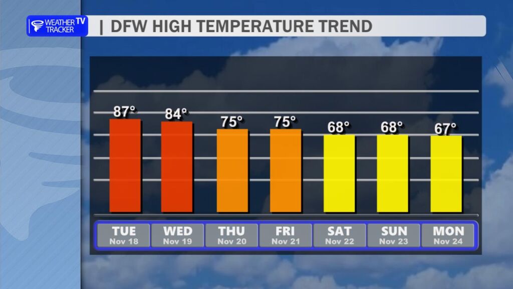
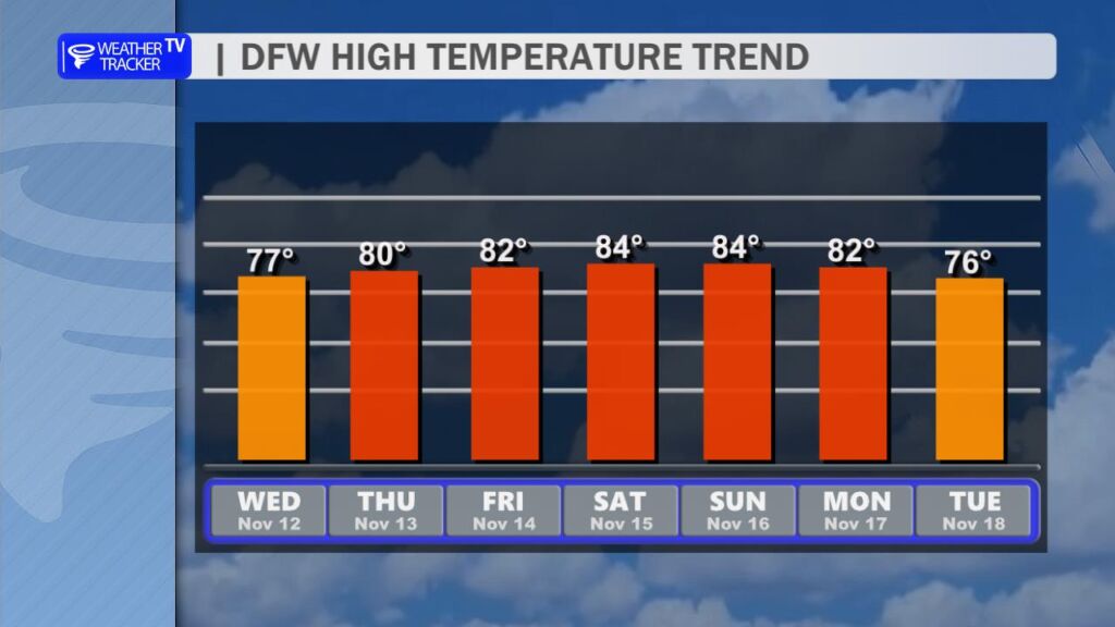
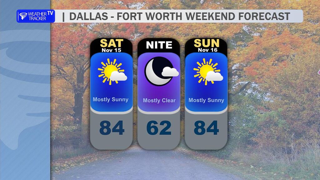
A very active stretch of North Texas weather kicks off later today and runs through early Friday morning.

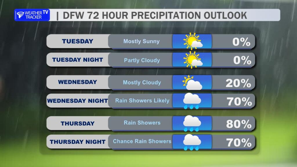
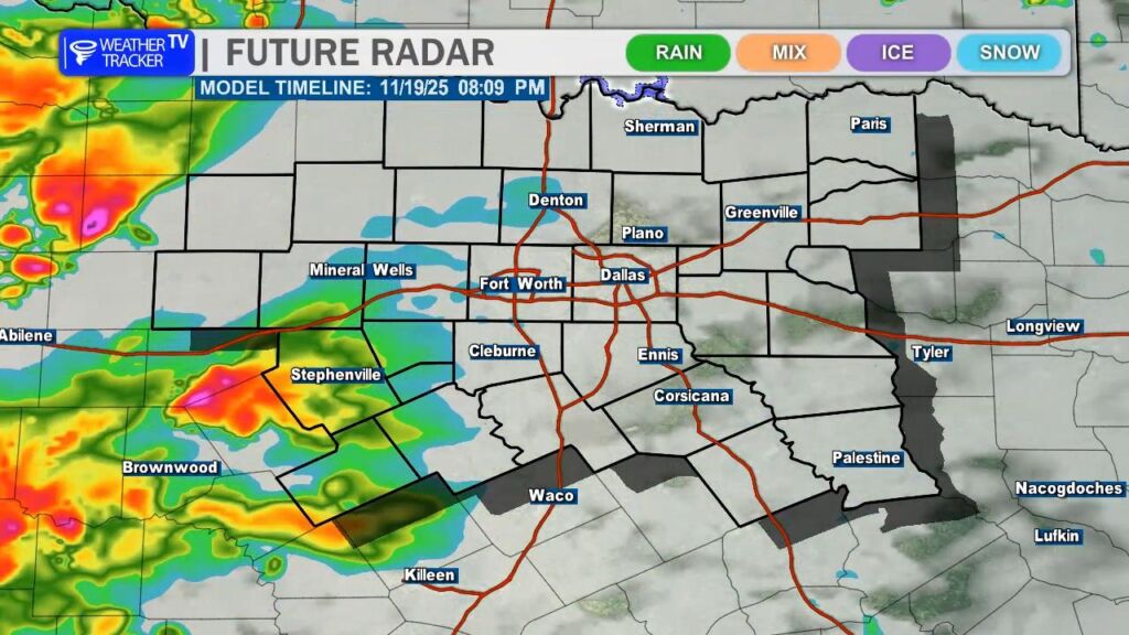
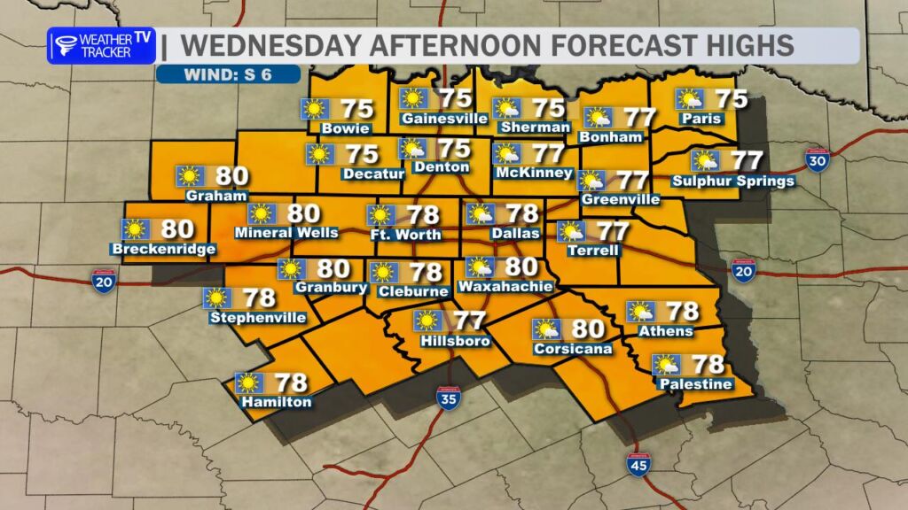
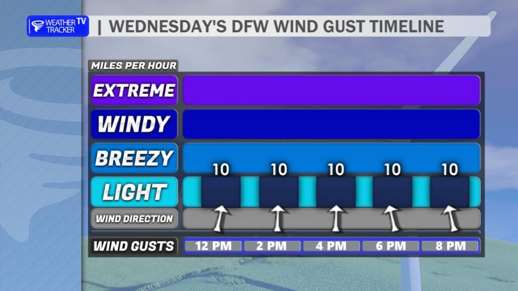
Today (Wednesday): Scattered showers and thunderstorms will begin developing this afternoon, mainly west of I-35. A sharp dryline will set up across the Big Country and western North Texas late this afternoon and evening. Any storms that manage to form along or just east of that dryline (generally west of a Graham, Mineral Wells, Stephenville line) will have the potential to become severe, with large hail (some possibly golf-ball size or larger) and damaging wind gusts as the primary threats. Tornado risk appears very low, but not completely zero in those far western counties.

Although there is an isolated risk of severe weather across all of North Texas – the more likely area would be our western counties through the evening hours.
Half dollar sized hail and winds up to 60 mph are the primary severe weather concerns.

Overnight: scattered showers and a few rumbles of thunder will continue across the region, but widespread severe weather is not expected.

Future Radar depiction across North Texas late day Thursday.

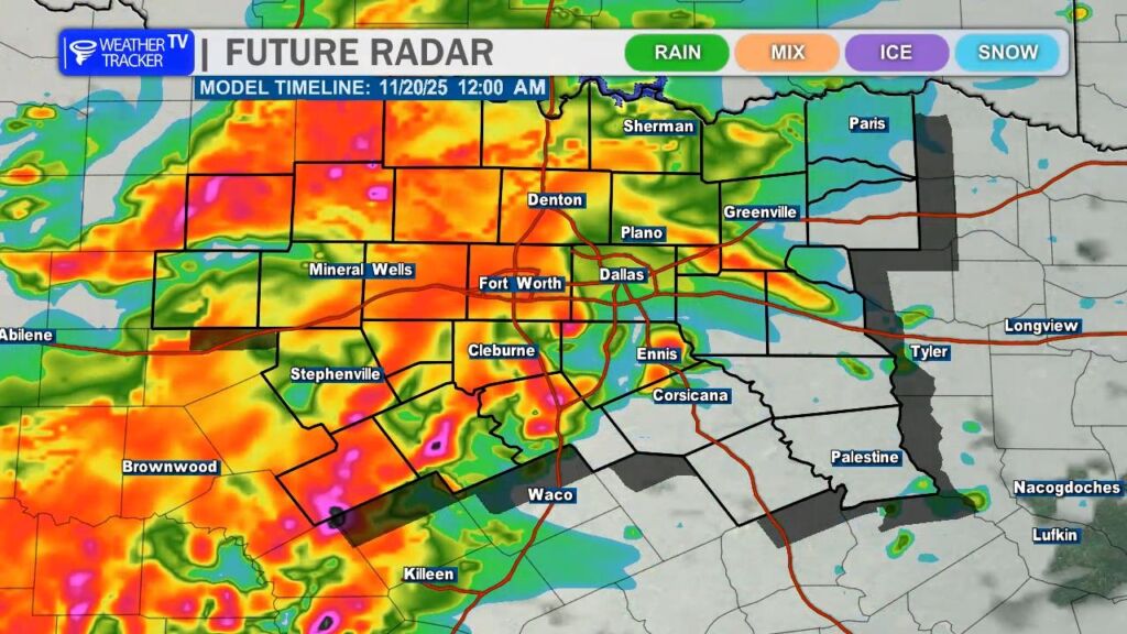
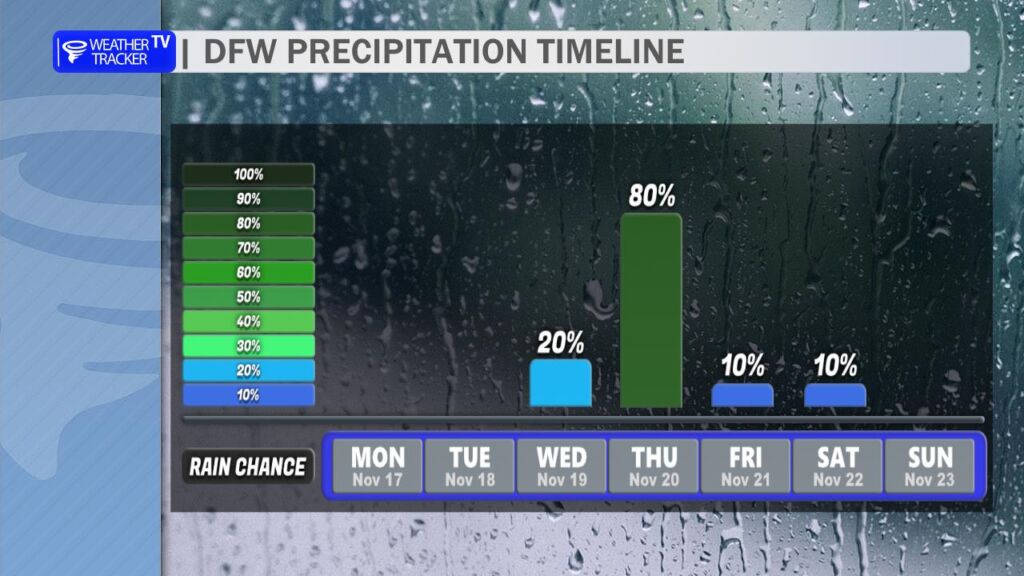
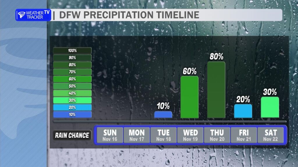
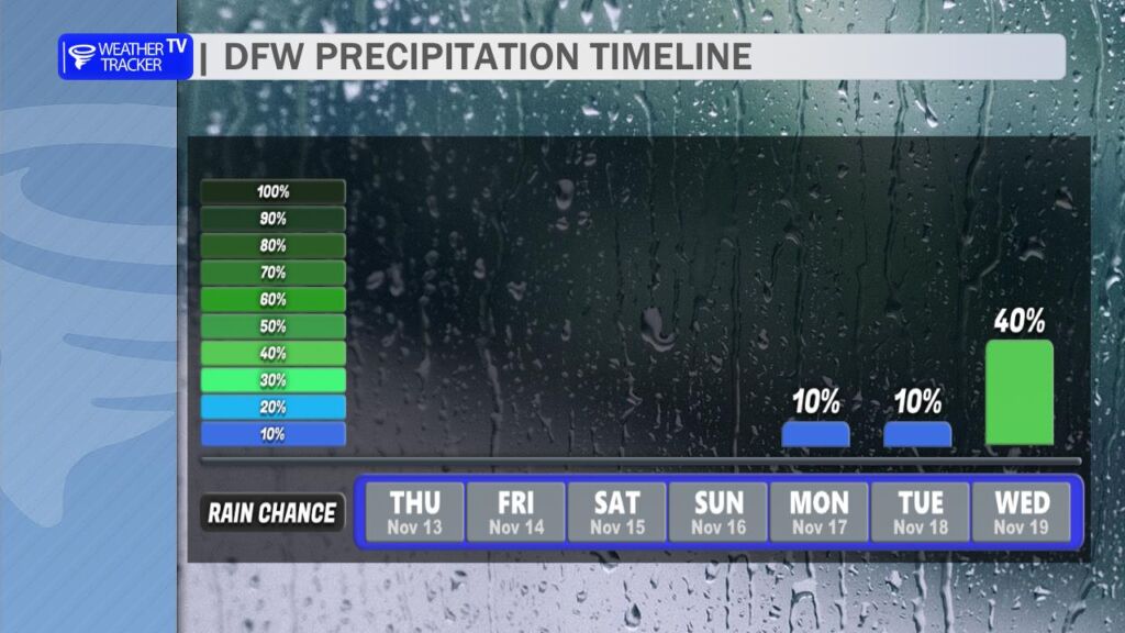
Thursday: Rain coverage increases significantly, especially from mid-morning onward. The Thursday morning commute across the DFW Metroplex will likely be wet, with periods of moderate to heavy rain at times. The evening commute looks even wetter – widespread rain and embedded heavy downpours are expected across North Texas during the afternoon and evening drive. Ponding on roadways, low-visibility, and hydroplaning will all be concerns.

Rain gradually tapers off from west to east late Thursday night into early Friday morning as the upper-level system finally pulls away.

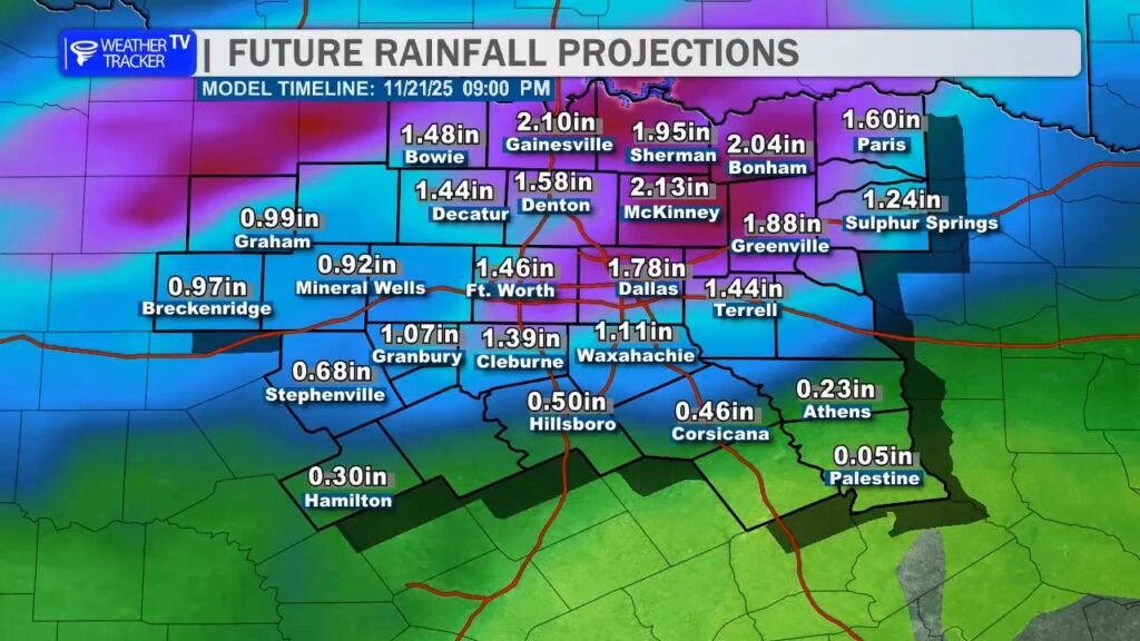
Rainfall Totals (through early Friday morning):

  • Most of the DFW Metroplex and areas east: 1.5–3 inches common
  • Isolated higher amounts of 3–5 inches possible, especially in areas that see repeated rounds of heavy rain or training storms

Bottom line: Keep the umbrella handy the next 36 hours, plan for extra travel time Thursday (especially the evening commute), and stay weather-aware this evening if you live in our far western counties. We’ll keep you updated hour-by-hour as this active pattern unfolds!

Dallas-Fort Worth Shatters 51 Year Old November Heat Record

The official weather station at Dallas-Fort Worth International Airport soared to 87° this afternoon, officially breaking the previous November 18 record high of 83° set way back in 1973 – that’s a full 51 years ago.

To put this in perspective:

  • The average high for mid-November in DFW is around 66°.
  • Today’s 87° is more typical of early September than late fall.
  • This is now the latest 85°+ day ever recorded in the DFW climate record (previous latest was November 15, 2016, at 88°).
  • It’s also only the fourth time on record that DFW has reached 85° or higher this late in the calendar year.

Remarkable warmth for so deep into November – a testament to the powerful upper ridge that has parked itself over Texas this week. Enjoy it while it lasts… cooler air finally arrives by the weekend.

North Texas Weather Update

Today (Tuesday): Get ready to break out the shorts and t-shirts one more time – it’s going to be HOT across North Texas!
We’re expecting a high around 87° in the Dallas-Fort Worth Metroplex this afternoon, which would easily smash the old record high of 83° set way back in 1973. Some spots west and northwest of DFW – especially out in the Big Country will flirt with or even touch the low 90s. Yes, you read that right… 90s in mid-November!

Enjoy it while it lasts, because this summer-like warmth is on borrowed time.

Big Changes Coming Mid-Week:

A strong upper-level storm system dives into the region late Wednesday into Thursday, bringing a dramatic pattern shift.

Severe weather possible in our western counites Wednesday evening with mainly a hail and wind threat.
A solid wave of rain and storms moves across the area Wednesday night. The Thursday morning commute looks wet in the DFW Metroplex.
  • Wednesday evening (mainly west of I-35): A narrow window exists for severe thunderstorms to develop across our western counties (think areas like Graham, Mineral Wells, Stephenville, and points westward). The main threats with any discrete supercells that form will be large hail and damaging wind gusts. These storms will be moving in quickly from West Texas.
  • Wednesday night into early Thursday: The individual storms are expected to merge into a larger complex/line of storms that sweeps east across the entire region overnight. Heavy rain and gusty winds will be possible with this line.
  • Thursday: Additional rounds of showers and thunderstorms are likely through the day as the main upper low moves overhead. Rainfall rates could be high at times, and localized flooding will become an increasing concern, especially in areas that pick up repeated rounds of heavy rain or where storms train over the same locations.

Rainfall totals through Thursday night look to range from 1–3 inches area-wide, with isolated higher amounts (4+ inches) possible where the heaviest bands set up.

Bottom line: Soak up the record heat today, stay weather-aware Wednesday evening (especially west), and prepare for a soggy, windy, and cooler Thursday. Fall is finally making a forceful comeback.

Very Warm Start to the North Texas Workweek

Get ready, North Texas – the next couple of days are going to feel a lot more like early October than mid-November.

Today (Monday, Nov 17)
We’re flirting with the all-time November 17 record high at DFW of 87° (set in 1938 & tied in 2013 and 2019). The official forecast high is 86°, which means we’ll either tie or come within 1 degree of the record. Morning lows only dipped into the upper 60s, so it’ll feel muggy and summer-like right from the start.

Tuesday (Nov 18)
We go for broke on the record books. The November 18 record stands at 83° (1973), but the forecast high is an eye-popping 87°. That would smash the daily record by 4 degrees and would be one of the warmest November days ever recorded in North Texas. Widespread mid-to-upper 80s are expected from Dallas-Fort Worth down through Waco and even into parts of Central Texas.

This ridiculous warmth is courtesy of a strong upper-level ridge parked over the southern Plains and a gusty south wind pumping in deep Gulf moisture and very mild air.

Mid-to-Late Week Pattern Flip
Enjoy the heat while it lasts – big changes arrive Wednesday night into Thursday as a potent upper-level trough and cold front sweep in from the west.

  • Rain chances ramp up quickly Wednesday night and continue into Friday
  • Some embedded thunderstorms are likely; a few could produce heavy downpours (1–3″+ possible in isolated spots)
  • The severe-weather threat still looks low (limited instability), but an isolated strong storm or two can’t be totally ruled out
  • Localized flooding will be the main concern, especially in poor-drainage and urban areas

This Weekend – Back to Reality
The same system ushers in a legit shot of chilly November air. Highs this weekend look to only reach the low-to-mid 60s with morning lows dropping into the 40s (maybe even upper 30s north of I-20 by Sunday morning). Feels like fall finally decided to show up!

Bottom line: Soak up the record-challenging warmth the next 48 hours because a much cooler and wetter pattern takes over by midweek. Stay weather-aware later this week for potential heavy rain and minor flooding risks.

The Week Ahead

Today’s Forecast (Sunday, November 16)

Expect another warm afternoon across North Texas, though we’ll dial back the intensity from yesterday’s record-breaking heat.

  • DFW Record Recap: Yesterday (Saturday, Nov 15), DFW Airport soared to 89°, shattering the previous daily record of 87° set way back in 1955. That’s a 70-year-old record now in the books!
  • Today’s Highs: A weak surface boundary slipping through the region this morning will ease winds and shave a few degrees off the mercury. Look for afternoon highs in the low to mid-80s (82–85°F) across the Metroplex, with upper 70s to low 80s along and north of I-20.
  • Winds: Lighter and more variable compared to yesterday’s gusty southwesterly flow. Expect 5–12 mph with occasional gusts to 15 mph, shifting from southwest to northwest behind the boundary.
  • Sky Cover: Mostly sunny to partly cloudy. A few fair-weather cumulus may bubble up this afternoon, but no rain is expected.

Short-Term Outlook

Monday (November 17)

The warm-up resumes! High pressure rebuilds, pushing temperatures back into the mid to upper 80s (85–88°F) under mostly sunny skies. Winds return from the south at 10–15 mph. It’ll feel more like early October than mid-November.

Tuesday (November 18)

Continued warm with highs in the mid-80s. Increasing clouds late as our next system approaches from the west. Overnight lows stay mild in the mid-60s.


Main Weather Maker: Wednesday–Thursday (November 19–20)

A potent upper-level trough and associated surface low will swing across the Southern Plains, bringing the first widespread rain chance in weeks. Multiple waves of showers and thunderstorms are likely, with the highest coverage Wednesday night into Thursday morning.

Key Impacts:

  1. Heavy Rainfall & Flooding Risk
  • Areal average rainfall: 2–3 inches
  • Localized higher amounts: up to 4 inches possible, especially along/east of I-35 where training storms may develop
  • Flash Flood Concern: Urban areas (Dallas, Fort Worth, Arlington) and low-lying spots will be most vulnerable. Creeks and streams may rise quickly.
  1. Severe Weather Potential (Low-End)
  • Primary Threats: Large hail (up to quarter-size) and damaging wind gusts (50–60 mph)
  • Tornado Risk: Low, but not zero – any discrete storms ahead of the main line could rotate
  • Greatest window: Wednesday afternoon/evening across Central TX, shifting east into North TX Wednesday night
  1. Timing Breakdown
  • Wednesday AM: Scattered showers possible, mainly west of I-35
  • Wednesday PM–Night: Main line of storms pushes in from the west; heaviest rain likely 6 PM Wednesday – 6 AM Thursday
  • Thursday: Lingering showers taper off by afternoon; much cooler with highs only in the 60s

Beyond Thursday

  • Friday–Saturday: Dry and cooler. Highs in the 60s, lows in the 40s.
  • Long-Range: Models hint at another system around Thanksgiving week, but confidence is low.

Bottom Line: Enjoy the warmth today and tomorrow, but prep for a soggy midweek. Secure loose outdoor items, clear gutters, and avoid flood-prone roads Wednesday night into Thursday. Stay weather-aware!

North Texas Weekend Forecast Update

Issued: Saturday, November 15, 2025 – 10:03 AM CST

Today: Late-Summer Heat Returns

Get ready for a very warm and quiet Saturday across North Texas. After a mild start, temperatures will climb quickly under mostly sunny skies.

  • DFW Metroplex: Highs in the mid 80s
  • Big Country & Western Counties (Mineral Wells, Graham, Breckenridge): Upper 80s to low 90s possible
  • Winds: South/southwest at 5–15 mph
  • Humidity: Moderate, but dew points in the 60s will make it feel a bit muggy by afternoon

Bottom line: Feels more like late September than mid-November. Perfect for outdoor plans.


Sunday: Slightly Less Warm

A weak wind shift line (essentially a subtle cold front) will drift into North Texas late Saturday night into Sunday morning.

What to expect:

  • Morning lows in the upper 50s to low 60s
  • Highs drop 3–6° from Saturday (upper 70s to low-mid 80s)
  • Winds shift to the north/northeast at 10–15 mph
  • Still dry and mostly sunny

Not an actual chilldown, but enough to take the edge off the heat.


Mid-Week Storm Threat Brewing

The quiet pattern won’t last forever. The latest model guidance (GFS, Euro, HRRR) continues to highlight a potent storm system arriving Wednesday into Thursday (Nov 19–20).

Key Concerns:

  • Severe Weather Potential: Instability + strong wind shear could support organized storms, including:
  • Large hail
  • Damaging wind gusts
  • Isolated tornadoes (still low confidence on coverage)
  • Heavy Rain & Flooding: Widespread 1–3 inches possible, with locally higher totals (4″+) in slow-moving cells
  • Timing: Main window looks Wednesday afternoon through Thursday

Confidence is increasing, but details (exact track, intensity) will sharpen over the next 48–72 hours.


Pro Tip: If you’ve got travel or outdoor plans mid-week, stay weather-aware. We’ll have hour-by-hour updates starting Monday as the threat evolves. Enjoy the bonus summer weekend while it lasts, North Texas! ☀️

North Texas Weekend Forecast: Warm, Sunny, and Breezy

North Texas Weekend Forecast: Warm, Sunny, and Breezy – With a Mid-Week Storm Watch

Get ready for a delightfully warm and breezy afternoon across North Texas today, with high temperatures climbing into the lower to mid 80s under mostly sunny skies. A gusty south breeze stays up through the daylight hours.

The warm and breezy conditions stick around all weekend long. Saturday and Sunday will both feature wall-to-wall sunshine with highs in the low to mid 80s – unusually warm for mid-November, but certainly welcome for anyone looking to enjoy the outdoors. Mornings will start mild in the upper 50s to low 60s, warming quickly after sunrise. Whether you’re doing some early holiday shopping, raking leaves, or just soaking up the sun, conditions will be near ideal.

Friday evening is shaping up beautifully for any after-work or weekend kickoff plans. As the sun sets, temperatures will ease through the 70s with clear skies and a gentle breeze – perfect for dinner on a patio, or a stroll on The Katy Trail.

Looking ahead, the dry and warm pattern holds through the early part of next week. However, a shift arrives by midweek – currently targeting Wednesday into Thursday – as a potent storm system approaches from the west. This system has the potential to bring the first widespread rain in weeks, with scattered strong to severe thunderstorms possible, especially across central and eastern parts of North Texas.

*Initial look at rainfall projections – these numbers will continue to change.

Along with gusty winds and hail in the stronger storms, heavy rainfall will be a concern. Some areas could see 1–3 inches of rain in a short time, raising the risk of localized flash flooding, particularly in low-lying spots, urban areas with poor drainage, and along creeks and streams.

For now, enjoy the sunshine and warmth while it lasts – North Texas is in for a gorgeous, late summer-like weekend before Mother Nature reminds us it’s still storm season.

Warm & Breezy Through the Weekend

Today’s Forecast (Thursday): Expect another day of above-normal temperatures across North Texas, with highs climbing back into the 80s – a solid 5-10° warmer than seasonal averages for mid-November. South winds will pick up, becoming breezier through the afternoon and evening, gusting 15-25 mph in many areas. These winds will feel warm and humid, carrying moisture from the Gulf, but conditions remain dry with plenty of sunshine.

Friday & Weekend Outlook: The warm-up continues. South winds stay gusty into Friday and linger through the weekend, keeping us in a stable, high-pressure pattern. Highs hold steady in the upper 70s to low 80s each day, with lows in the comfortable 60s overnight. Skies stay mostly clear to partly cloudy—perfect for outdoor plans, early holiday shopping, or yard work.

Extended Outlook (Next Week): The pattern shifts by mid-next week (Tuesday-Wednesday), as a frontal boundary approaches from the northwest. This brings our next chance of rain and thunderstorms, with models showing 20-40% odds of scattered showers or storms. Amounts look light (under 0.5 inches), but keep an eye on updates as it nears. Highs cool slightly to the 70s behind any activity.

Warm Up, Weekend Rain Chances Dry Up

Temperature Rebound Underway
After a brief dip into cooler conditions, North Texas is firmly back in a warm pattern this week. High temperatures will climb steadily, reaching the low-to-mid 80s by Thursday and holding there through the weekend. Daytime highs on Thursday and Friday should peak between 80–84° across the Dallas-Fort Worth Metroplex, with suburbs like Denton, Frisco, and Plano seeing similar values. Overnight lows will remain mild, bottoming out in the upper 50s to low 60s.

DFW high temperature trend over the next seven days.

Wind Gusts on the Horizon
Today features light and variable winds, with gusts generally below 10 mph. However, a subtle pattern shift begins Thursday as high pressure slides eastward. This will usher in a south-to-southwest breeze by late week, with sustained speeds of 10–15 mph and occasional gusts to 20–25 mph on Friday and Saturday. The returning southerly flow will not only reinforce the warm-up but also import slightly higher humidity, pushing dew points into the mid-60s by the weekend.

Weekend Forecast: Dry and Warm
Initial concerns about weekend rain have evaporated. An upper-level storm system previously progged to bring showers has lifted farther north, tracking across the Central Plains and Upper Midwest instead. As a result, rain chances for Saturday and Sunday have dropped to near zero. Expect mostly sunny to partly cloudy skies, with high temperatures 83–85° both days. The combination of warmth, breezy conditions, and low rain probability makes for ideal outdoor plans.

Next Weather Maker: Tuesday–Wednesday
The first legitimate rain chance in over a week arrives early next week. A slow-moving upper-level trough will dig into the Southern Plains, with its associated surface low taking a favorable track across Oklahoma and North Texas. Scattered showers and thunderstorms are likely Tuesday afternoon into Wednesday morning, with the best coverage along and east of I-35. Rainfall totals look modest for now – generally 0.25–0.75 inches across the region – but isolated higher amounts are possible where storms train. Severe weather risk appears low at this range, though a few stronger cells could produce gusty winds and small hail Tuesday evening.

North Texas Weather Update & Veteran’s Day Forecast

Issued: Tuesday, November 11, 2025 – 10:03 AM CST


Happy Veteran’s Day, North Texas!

To every veteran and active-duty service member in the DFW Metroplex and beyond – thank you. Your courage, sacrifice, and dedication keep our nation strong. Today, we honor you with gratitude that words alone can’t fully express.

Whether you’re marching in a parade, attending a ceremony, or simply spending the day with family, here’s what North Texas weather has in store.


🌞 Today’s Forecast (Tuesday, Nov 11)

High: 71° (DFW Metroplex)
Conditions: Sunny, dry, and seasonably mild
Winds: South-southwest 15–25 mph, gusts up to 30 mph
Humidity: Very low (20–30%)

Bottom Line: A gorgeous fall day for Veteran’s Day events. Just secure loose items (flags, tents, chairs).


🔥 Elevated Fire Danger Today

  • Peak gusts near 30 mph + low humidity = high wildfire risk
  • Outdoor burning is strongly discouraged across all of North Texas
  • Avoid sparks: no open flames, discard cigarettes properly, and park vehicles away from dry grass

Counties under heightened concern: Dallas, Tarrant, Collin, Denton, Parker, Wise, and points west toward the Big Country.


📈 Rest of the Work Week: Warming Trend Ahead

DayHighLowConditionsNotes
Wed77°50°Mostly sunnyLight wind
Thu82°57°Sunny, warmerFeels like early fall
Fri82°62°Partly cloudyWarmth Continues

A slow-moving ridge of high pressure will dominate, pushing temps 5–10° above normal by late week.


🌧️ Weekend Storm System: Rain Chances Returning

Confidence: Moderate (timing/track still uncertain)
Potential Impacts:

  • Scattered showers/storms possible Saturday night into Sunday
  • Rain totals: 0.25″–0.75″ (locally higher north/east of DFW)
  • Severe threat: Low, but gusty winds possible in stronger cells
  • Cooler air follows: Highs drop back into the 70s early next week

Timeline Jiggle Alert: Models do not agree on the storm’s speed and track. So the forecast will continue to change some as we get closer to the weekend.

  • Earlier arrival (Sat afternoon): More widespread rain
  • Later arrival (Sun Evening): Drier Saturday, wet Sunday Late

🎖️ Parade & Event Weather Highlights

  • Dallas Veterans Day Parade (Downtown): Sunny, near 60 at 11 AM, winds gusting 25–30 mph
  • Fort Worth Parade: 60s kickoff, gusty but dry
  • Arlington Ceremony (Veterans Park): Mild & sunny – perfect for photos