Perfect NYE Weather: Sunny 60s Today, Cozy 50s at Midnight in North Texas

Happy New Year’s Eve, North Texas! 🎉

The final day of 2025 is shaping up to be a real keeper across the Dallas-Fort Worth Metroplex and beyond. Expect mostly sunny skies, light winds, and comfortably mild temperatures that make it perfect for any last-minute outdoor plans or evening celebrations.

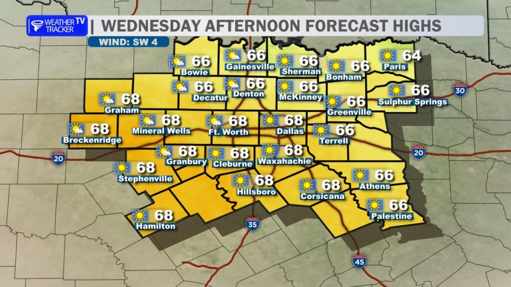
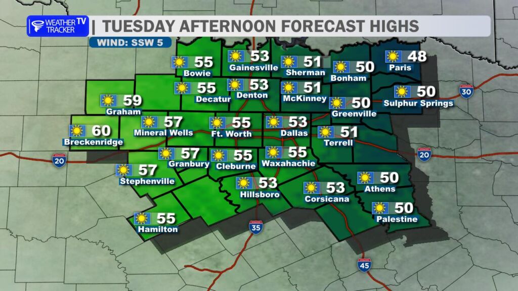
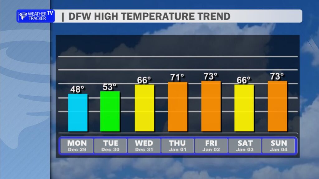
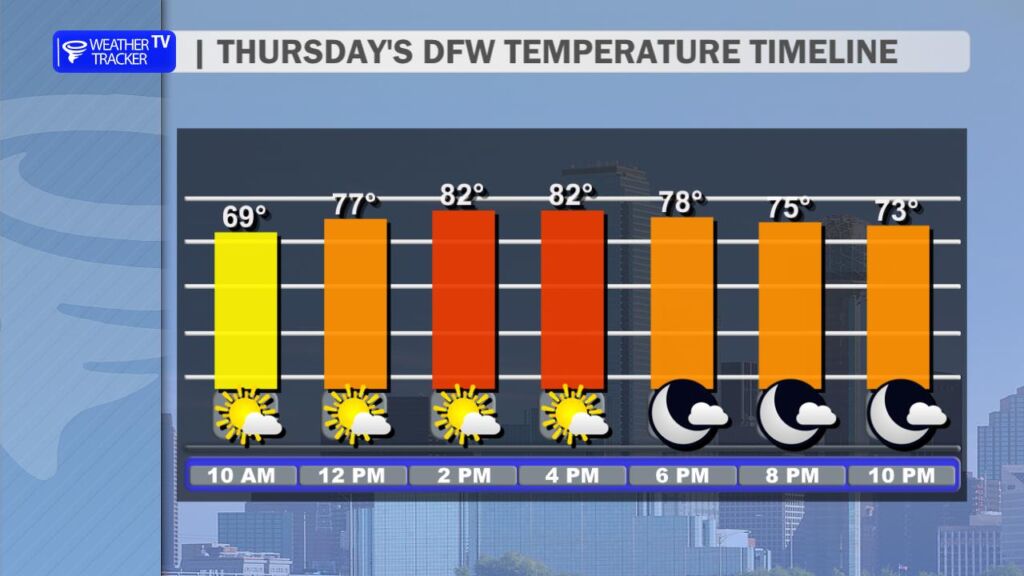
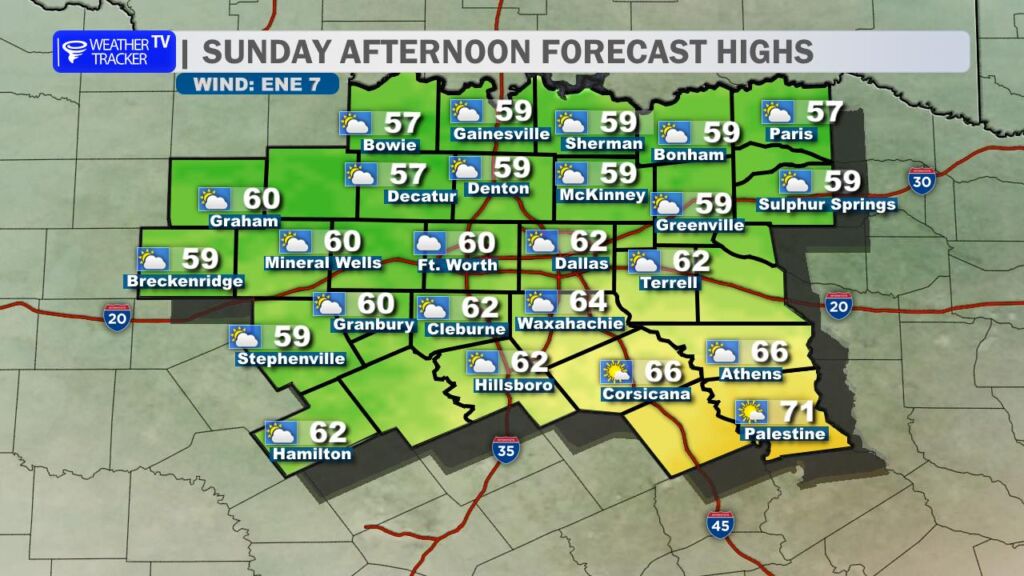
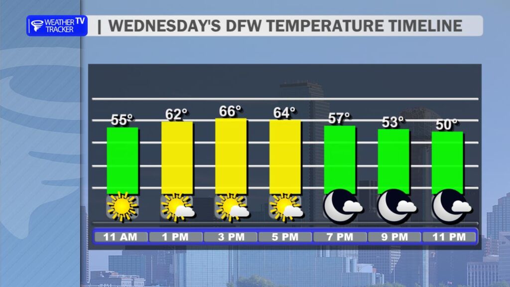
Highs today will climb into the mid to upper 60s, feeling even nicer under clear blue skies. It’s a beautiful winter day with plenty of sunshine to enjoy – whether you’re out for a walk, running errands, or prepping for tonight.

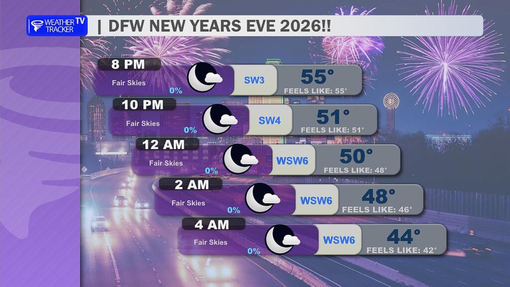
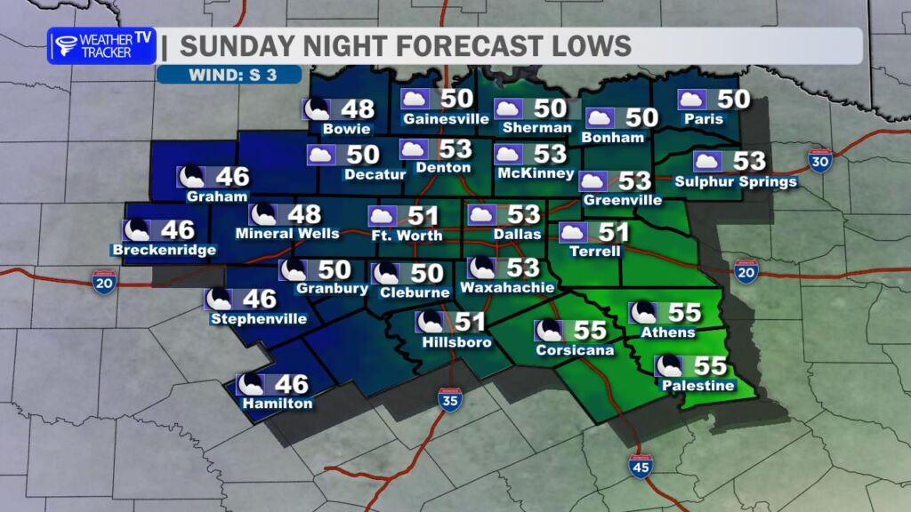
As we head into the evening and midnight countdown, temperatures will cool gradually into the low to mid 50s early evening, dropping to around 50° by the stroke of midnight. It’ll be chilly but not overly cold – a light jacket or sweater should do the trick for outdoor festivities, with light winds and fair, clear skies overhead. No rain or major weather worries to dampen the party.

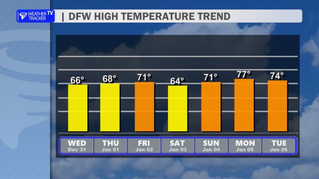
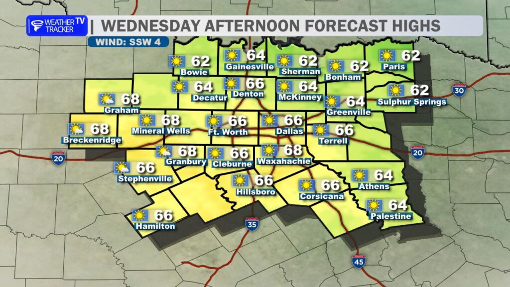
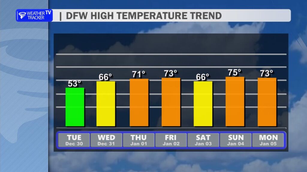
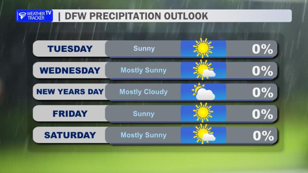
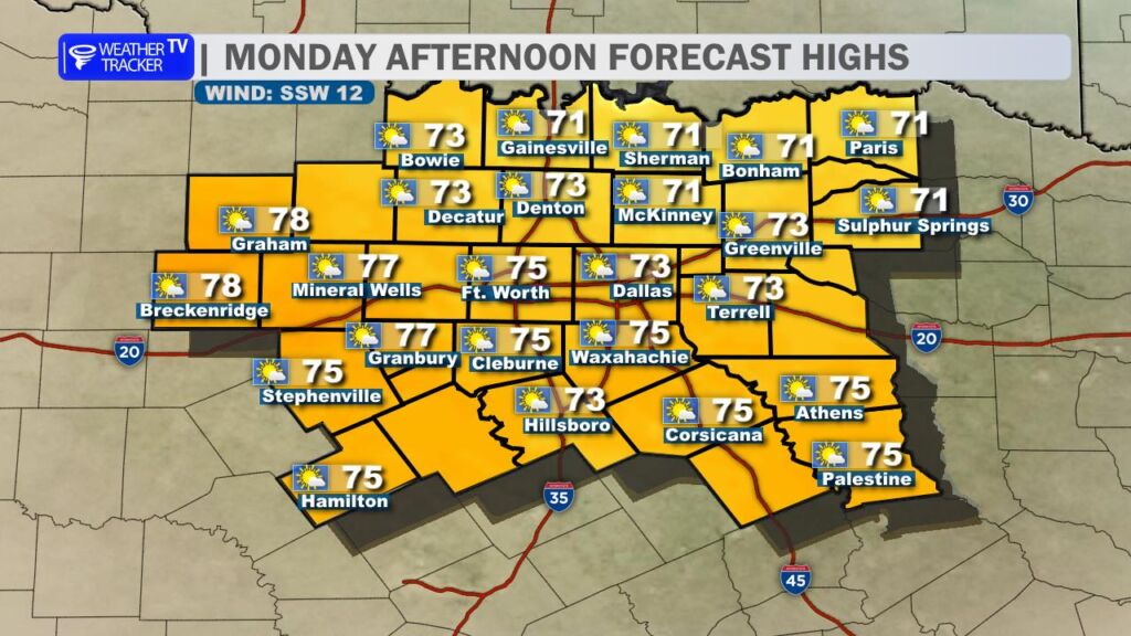
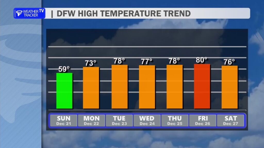
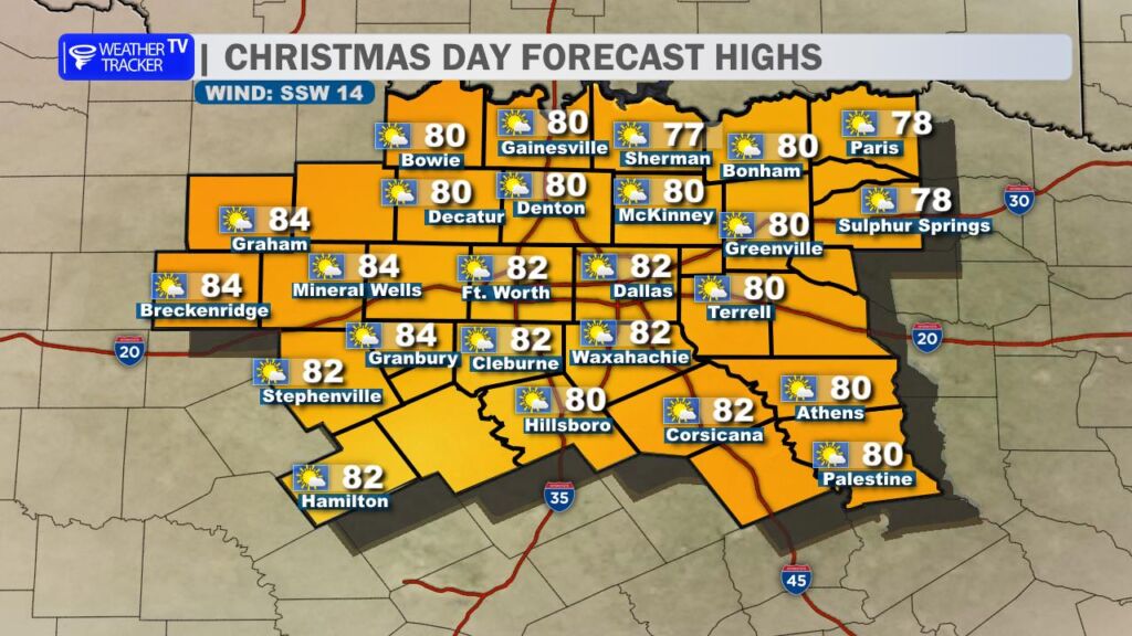
Looking ahead to the first week of 2026, the dry trend continues with above-normal temperatures taking hold. Expect highs trending into the 60s early in the week (upper 60s on New Year’s Day) and pushing into the lower 70s by the weekend. Mostly clear to partly cloudy skies, light winds, and no significant rain in sight.

Wishing everyone in North Texas a safe, joyful New Year’s Eve and a fantastic 2026! -William

Chilly Mornings Fade Fast: Sunny 50s Today, 70s by New Year’s Day

Good Tuesday morning, North Texas!

We kicked off the day with another chilly start, as morning lows dipped mostly into the 20s across the region around sunrise, bringing that classic crisp winter feel. But don’t bundle up too tightly just yet – the pattern is shifting in our favor.

Today (Tuesday, December 30): Expect a beautiful rebound this afternoon with crisp highs climbing into the low to mid-50s. Skies will stay mostly sunny to sunny, winds will remain light, and it’ll feel refreshing under that clear blue sky. Perfect for getting outside after the cold morning.

The warming trend really picks up steam tomorrow:

  • Wednesday (December 31 – New Year’s Eve): Highs bounce into the mid-60s (near 64–66° in the metroplex), with continued sunny conditions and light winds. It’ll be a gorgeous way to ring in the new year – clear skies and cool temperatures for evening festivities.

And it just keeps getting better as we head into 2026:

  • New Year’s Day (Thursday, January 1): Highs climb back into the upper 60s to near 70°, with partly sunny skies and a touch more breeze. We’re talking unseasonably warm and pleasant weather to kick off the new year – no winter chill in sight.

Looking ahead, the overall pattern stays quiet and dry through the first few days of January. No meaningful rain or precipitation chances are in the forecast for at least the next week, with the dry streak continuing. High pressure will keep things settled, and temperatures will trend well above normal for this time of year.

Chill is On: North Texas Bundles Up for a Frosty Start to the Week

Good Monday morning, North Texas!

Monday morning actual observed low temperatures.

What a sharp contrast after that unseasonably warm Christmas weekend – we’ve got a classic post-frontal chill in the air today, December 29, 2025. Most folks woke up to crisp temperatures in the 20s and low 30s.

Monday’s North Texas Forecast Map
Monday’s DFW Wind Chill Timeline

Temperatures will stay on the chilly side through the afternoon, topping out in the mid to upper 40s around Dallas-Fort Worth. A lingering north breeze (gusts still noticeable) will keep wind chills in the 30s for much of the day, so bundle up if you’re heading out. Expect increasing cloud cover as the day progresses, but no precipitation locally.

Monday’s North Texas Wildfire Danger

Speaking of dry… with low humidity, brisk winds, and all the winter-killed/dormant vegetation out there (think brittle grasses and brush), elevated grass and wildfire danger is in play across much of the region today. Outdoor burning is strongly discouraged until conditions improve – better safe than sorry with these tinder-dry fuels.

Monday Night’s Forecast Lows

Another cold night is on tap tonight, with lows dropping below freezing everywhere across North Texas. Expect the coldest spots north of DFW – especially along and near the Red River Valley – to dip into the low to mid 20s.

DFW High Temperature Trend

The pattern shifts quickly from here. A warm-up gets underway tomorrow (Tuesday), with highs rebounding nicely into the low to mid 50s. By New Year’s Day (Thursday), we’re looking at a much more comfortable climb to near 70 – perfect for ringing in 2026 without the heavy coats.

Stay warm out there today, North Texas – layers are your friend. -William

Winter’s Dramatic Return: Record Warmth Ends as Powerful Cold Front Sweeps North Texas

Sunday’s North Texas Forecast Map

After a stretch of record-setting holiday warmth that felt more like spring than late December, winter is making a dramatic return to North Texas today, December 28, 2025.

Temperatures begin to tick down quickly behind the front.

I’m tracking a strong cold front sweeping southward across the region this afternoon and evening, bringing a sharp and noticeable change. Before the front arrives, expect one last taste of unseasonable heat: temperatures will climb into the upper 70s to low 80s under mostly sunny to partly cloudy skies, with breezy conditions adding to the mild feel.

Winds snap to the north and become blustery behind the front.
Wind Advisory in effect through the overnight. Peak wind gusts of 45 mph possible.

You’ll know exactly when the front passes through – winds will abruptly shift to the north, strengthening rapidly with sustained speeds of 25-35 mph and gusts exceeding 35-45 mph in many spots. In the the Metroplex the cold front passage is expected between 2 pm and 4 pm. This has prompted a Wind Advisory for all of North Texas, in effect through the early morning hours (around 3 AM or later in some areas). Secure loose outdoor items, be cautious on the roads (especially high-profile vehicles), and watch for blowing dust or debris.

Future radar by late afternoon. A few showers or T-Storms possible – east.

A few isolated showers or thunderstorms are possible near and just ahead of the front, mainly confined to eastern and southeastern counties. The overall probability remains low (around 10-20%), and any rain would likely be light – only trace amounts expected.

Sunday Night North Texas Forecast Map

Behind the front, temperatures will plummet quickly. Tonight will turn sharply colder, with most of North Texas dropping into the mid-to-upper 30s by morning. Freezing temperatures are possible along the Red River Valley and in sheltered northern spots. Add in the gusty north winds, and wind chills could feel like the 20s by sunrise – bundle up if you’re heading out early!

Monday’s North Texas Forecast Map

Monday looks blustery and chilly, with highs struggling to reach the mid-to-upper 40s. The north wind will remain brisk (though lighter than tonight), making it feel even colder – plan for layers and a windproof jacket.

DFW High Temperature Trend

The deep chill won’t last long. Temperatures will gradually rebound through the week, climbing back into the 50s by midweek and reaching the 60s for highs around New Year’s Day. We’ll ease back toward more seasonable (but still mild) conditions to close out 2025 and welcome 2026.

From Shorts to Jackets in 24 Hours: DFW’s Wild Weather Ride to Close Out 2025

Good Saturday morning, North Texas! 🌤️

What a way to wrap up 2025 – we’re looking at another unseasonably warm day across the Dallas-Fort Worth area, with a legitimate shot at tying or breaking the daily record high – again.

Skies will be variably cloudy today, with generally more cloud cover building in areas southeast of DFW. Winds will be breezy out of the southwest at 15-20 mph, adding a touch of that classic Texas warmth to the air.

The big headline? Temperatures. My forecast high is around 84°, which would push us past the current record high of 82° set back on this date in 2005. We’re talking well above the typical December normal highs which usually hover in the upper 50s.

If you’re heading out for Saturday evening or night plans, it’ll stay pleasantly mild with fair to partly cloudy skies continuing. Overnight lows will only dip into the mid to upper 60s – no jacket required for most folks.

Sunday brings the turning point: a strong cold front will barrel through late in the day, ushering in a classic Blue Norther-style change. Highs will still manage to reach the upper 70s to low 80s early on, but expect blustery north winds gusting over 30 mph (possibly higher) as the front passes.

A thin line of showers and isolated thunderstorms could pop up near and ahead of the front, mainly in the late afternoon/evening. Rainfall totals should remain very light – we’re not expecting any widespread soaking, and severe weather isn’t on the table today.

Behind the front, temperatures will plummet quickly. Monday and Tuesday look chilly with highs likely in the 40s and lows dipping into the 30s (widespread freeze possible Monday night into Tuesday morning). Bundle up if you’re out early next week!

Then we get a nice rebound as we close out the year – temperatures climb back into the 60s by the end of next week, finishing 2025 on a milder note.

North Texas December Heat Wave: 80s Today, Arctic Blast Incoming

Good Friday morning, North Texas! I hope everyone had a wonderful Christmas. As we wrap up the holiday week, we’re still basking in an impressive December heat wave that’s made this feel more like spring than winter.

Friday’s North Texas Forecast Map
Record high possible this afternoon.

Today (December 26, 2025), expect partly cloudy skies with a light southwest breeze keeping things comfortable. Highs will climb into the mid-80s – my forecast calls for around 84° across much of the DFW Metroplex. That’s right on the edge of tying or breaking the daily record high of 83° set back in 2008.

Saturday’s North Texas Forecast Map

Saturday looks similar – more record heat possible with highs again pushing into the low to mid-80s under mostly sunny skies. However, increasing cloud cover could creep in from the east, potentially holding temperatures in the upper 70s for our eastern counties (think Sulphur Springs, Athens and Palestine).

Future Radar depiction of a few showers or T-Storms near a cold front Sunday evening.

The big change arrives late Sunday as a strong Arctic cold front sweeps through. Expect howling northerly winds gusting strong, along with a few scattered showers and possible thunderstorms, especially near and ahead of the front. Rain chances are highest southeast of the Metroplex.

Monday’s North Texas Forecast Map

This front will deliver a dramatic cooldown – Monday’s highs will struggle to reach the upper 40s with brisk northerly winds making it feel even chillier. Bundle up!

DFW High Temperature Trend

After that sharp drop, temperatures will gradually rebound as we head into the final days of 2025. Expect highs climbing back into the 50s and eventually the 60s by mid-next week, bringing us more typical late-December conditions.

Get ready for that winter wake-up call. Have a great Friday! -William

No White Christmas Here: DFW’s Balmy Bid for Warmest Holiday on Record

Merry Christmas, North Texas! 🎄

Christmas Day North Texas Forecast Map
DFW Christmas Day Hour by Hour Timeline

What a gift from Mother Nature today – a very warm Christmas that’s anything but traditional. Highs are climbing into the low to mid-80s across the DFW area under mostly sunny to partly cloudy skies, with a breezy southwest wind keeping things feeling even toastier.

My forecast has DFW flirting with the all-time warmest Christmas record of 82°, set in 2021. We’re on track to tie or come very close to that mark, with current forecast projections hovering around 80–84°. This makes it one of the top warmest Christmases on record, with temperatures running 20–25 degrees above the normal high of about 56°. No holiday coats or sweaters needed today.

The near-record warmth sticks around tomorrow (Friday) with highs still pushing into the low-to-mid 80s, south breezes, and partly cloudy skies – potentially setting new daily records. The balmy pattern holds through Saturday and into Sunday afternoon, so enjoy this extended holiday heatwave while it lasts.

But change is on the way. We’re closely tracking a strong arctic cold front arriving later Sunday. You’ll feel it clearly: shifting to a chilly northerly wind, with temperatures dropping rapidly. That sets up a sharply colder Monday, with highs struggling to reach the 40s and wind chills making it feel even cooler. Overnight lows could dip into the upper 20s or low 30s early next week – some real winter weather.

Rain and thunderstorm chances ramp up with the front late Sunday. A narrow line of storms could develop, bringing brief heavy rain and gusty winds as it moves through quickly just ahead of the front. At this point, no severe weather is expected, but stay weather-aware if you’re traveling.

Temperatures should slowly rebound toward the middle of next week, heading into New Year’s – likely back to more seasonal levels in the 50s and 60s.

Merry Christmas and Happy Holidays. -William

Christmas in Shorts? North Texas Braces for More Near-Record Warmth

Merry Christmas Eve, North Texas! 🎄

What a way to kick off the holiday – we’ve started the morning with plenty of clouds and even some patchy fog hanging around, especially west of the Dallas-Fort Worth metroplex area.

As we head through the afternoon, those clouds should gradually thin out, letting more sunshine break through. Get ready for some seriously toasty weather: highs are climbing back into the 80s across most of the region – well above our usual late-December norms (which typically hover in the mid-50s). Feels more like a warm spring day than Christmas Eve!

And the warmth isn’t going anywhere tomorrow – Christmas Day looks nearly identical. We’re tracking a forecast high right around 78–82° (depending on the exact spot in the metroplex), which puts us in striking distance of the all-time record high for December 25 at DFW (82° set back in 2021). If we hit or top that, it’ll go down as the warmest Christmas on record.

The mild, dry pattern holds strong through Saturday, with more highs in the low to mid-80s and plenty of sunshine – perfect for outdoor holiday activities, post Christmas shopping, or just enjoying the unseasonably beautiful weather.

Then comes the big change: a strong cold front barrels through on Sunday. Expect a few scattered showers and maybe even an isolated thunderstorm or two as it moves across North Texas. Behind it, much cooler air rushes in – highs will tumble into the 40s by Monday, with lows potentially dipping into the 30s. It’s a classic Texas temperature rollercoaster!

Merry Christmas and Happy Holidays to you and yours. -William

No White Christmas – Sunshine and 70s Dominate North Texas’ Holiday Week

Good Monday morning, North Texas!

We’re kicking off a remarkably warm Christmas week ahead, with a steady warming trend that will make this holiday feel more like early fall than winter.

Today (Monday):
The warm-up begins in earnest, with high temperatures climbing back into the mid to upper 70s across the region. We’ll start the day with some morning clouds, but those should gradually clear out, giving way to plenty of afternoon sunshine. A south to southwesterly wind will pick up during the afternoon, becoming breezy with gusts topping out around 25 mph.

Tuesday:
Temperatures continue their upward climb, with much of North Texas pushing toward or even reaching near 80 degrees. Like Monday, we’ll see some morning clouds that should scatter by the afternoon, leaving us with mostly sunny skies and continued breezy conditions.

Christmas Eve (Wednesday):
Expect a repeat performance – highs in the mid to upper 70s, a light south breeze, and mostly sunny skies throughout the day. Perfect weather for any last-minute shopping or outdoor holiday preparations.

Christmas Day (Thursday):
Santa might want to swap the sleigh for shorts this year. We’ll see very warm conditions once again, with forecast highs in the DFW area reaching 78 degrees – flirting with the record high of 82 degrees set back in 2021.

Looking further ahead, our next cold front is currently projected to arrive late Saturday, which should finally bring a cool-down. By Sunday, highs will drop back into the 60s – a more seasonable feel to close out the weekend. For now, the forecast remains dry through the extended period, with no significant rain chances in sight.

Enjoy the unseasonably warm holiday week, North Texas. -William

Cooler Today, Then a Toasty Texas Christmas Ahead

Good Sunday morning, North Texas!

Sunday’s North Texas Forecast Map

After yesterday’s record-breaking warmth at DFW Airport, we’re settling back into more seasonal conditions today. A cold front swept through overnight, bringing a noticeable change. High temperatures this afternoon will range from the mid-50s north of the Metroplex to the low to mid-60s farther south, a solid 15-20 degrees cooler than Saturday. Expect a brisk north wind at 10-20 mph with occasional gusts near 25 mph, which will make it feel even cooler.

Visible satellite imagery showing a low deck of cloud cover over North Texas.
Sunday Night North Texas Forecast Map

A thick deck of low clouds has spread across the region this morning, and those clouds aren’t going anywhere soon. We’ll see a mostly cloudy to overcast sky through the afternoon and into tonight. The cloud cover will act like a blanket, preventing temperatures from dropping too much overnight – look for lows mainly in the low to mid-50s by Monday morning.

Monday’s North Texas Forecast Map

The warmup returns quickly on Monday. A south wind will pick up through the day, helping to scour out the morning clouds and bring back afternoon sunshine. Highs will climb back into the low to mid-70s.

DFW Temperature Trend

That warmer pattern holds strong right through Christmas week. We’ll see highs in the 70s Tuesday and Wednesday, pushing toward 80° on Christmas Eve and Christmas Day itself. Christmas Day currently looks mostly sunny and unseasonably warm with a high near 80° – just a couple of degrees shy of the record high of 82° set back in 2021. A very Texas-style holiday forecast.

Christmas Day Forecast Map

As of now, the entire period through Christmas remains dry – no precipitation is expected to interrupt your holiday plans.

Signs of a pattern change around December 28 with possible low-end rain chances.

Looking ahead, there are some early signs of a pattern change around Sunday, December 28. That could open the door to our next chance for rain and possibly a few thunderstorms as we head toward the end of the month and into early 2026. We’ll keep a close eye on that and update you as the details become clearer.

Stay warm and cozy today, North Texas. -William