Happy Wednesday, North Texas!
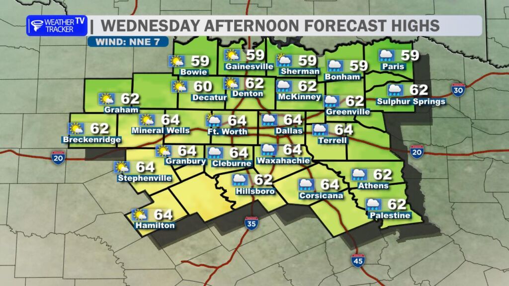
This morning kicked off damp for areas east of the DFW Metroplex, where light scattered showers were popping up. Those will gradually taper off as we head into the afternoon, giving way to clearing skies. Highs will reach around 60° across the region, accompanied by a light but brisk northeast breeze – perfect for a mild midweek day before things take a sharp turn.
The big story we’re watching is the major winter storm barreling in starting Friday and lingering through the weekend into early next week. The National Weather Service in Fort Worth has a Winter Storm Watch in effect for all of North and Central Texas from Friday afternoon through late Saturday night, with potential upgrade to a warning as details firm up.
Timing of the Arctic Front
The cold front’s arrival has shown signs of slowing slightly in recent model runs. Expect it to push into the Red River counties (far northern Texas) through the morning hours on Friday, reaching the DFW Metroplex by late afternoon/early evening. Chilly rain showers will already be underway across much of North Texas ahead of and with the front.

Once the front passes your location:
- Liquid rain quickly transitions to freezing rain as surface temperatures drop below freezing.
- Freezing rain looks to be the dominant type Friday night into Saturday morning, with potential for significant ice accumulation.
- By Saturday, it mixes with sleet, and precipitation may taper to light snow late Saturday into early Sunday morning in some spots.

This setup raises the risk of notable ice glazing across the area – potentially enough to cause tree damage, downed power lines, and localized power outages. Travel could become crippling, especially on bridges, overpasses, and untreated roads.
Dangerous Cold Ahead

Beyond the wintry mix, the real hazard is the prolonged dangerously cold air:
- Highs on both Saturday and Sunday will struggle to climb out of the 20s.
- Overnight lows will plunge into the teens, with DFW potentially bottoming out around 10° by Monday morning.
- Wind chills could feel even colder, dipping well below zero in some areas overnight Saturday into Sunday.

Temperatures are expected to stay below freezing from Friday evening through at least Monday (possibly into Tuesday in northern parts), increasing risks like frozen pipes, pet exposure, and vehicle issues.
Preparation Tips
Now’s the time to get ready – don’t wait until Friday!
- Stock up on essentials: food, water, medications, batteries, and blankets.
- Protect pipes: Insulate exposed ones, drip faucets if needed, and know how to shut off water if outages occur.
- Prepare for power bumps: Have flashlights, a charged phone, and backup heat sources (use safely!).
- Limit travel if possible during the heaviest precipitation and coldest periods.