Good Tuesday Morning, North Texas!

After a chilly start to the day with temperatures in the low to mid 30s across much of the region (and even some spots dipping into the upper 20s earlier), we’re looking at a pleasant, cool afternoon ahead. Highs will climb into the mid 50s for most areas, including the Dallas-Fort Worth metroplex, with a nice mix of sunshine and passing clouds. A light southerly wind will help moderate things and bring in just a bit of warmth – nothing dramatic, but it’ll feel better compared to the morning bite.


Overnight into Wednesday, we could see some light, scattered showers developing, mainly along and east of the I-35 corridor through the metroplex and into East Texas. These will be mostly spotty and produce very light rainfall totals – generally under a tenth of an inch in most spots, with perhaps slightly higher amounts farther east. Shower chances carry over into Wednesday, but they should taper off by early to mid-afternoon as drier air moves in. Expect partly cloudy skies Wednesday with highs rebounding into the low to mid 60s before another cooldown begins setting up.
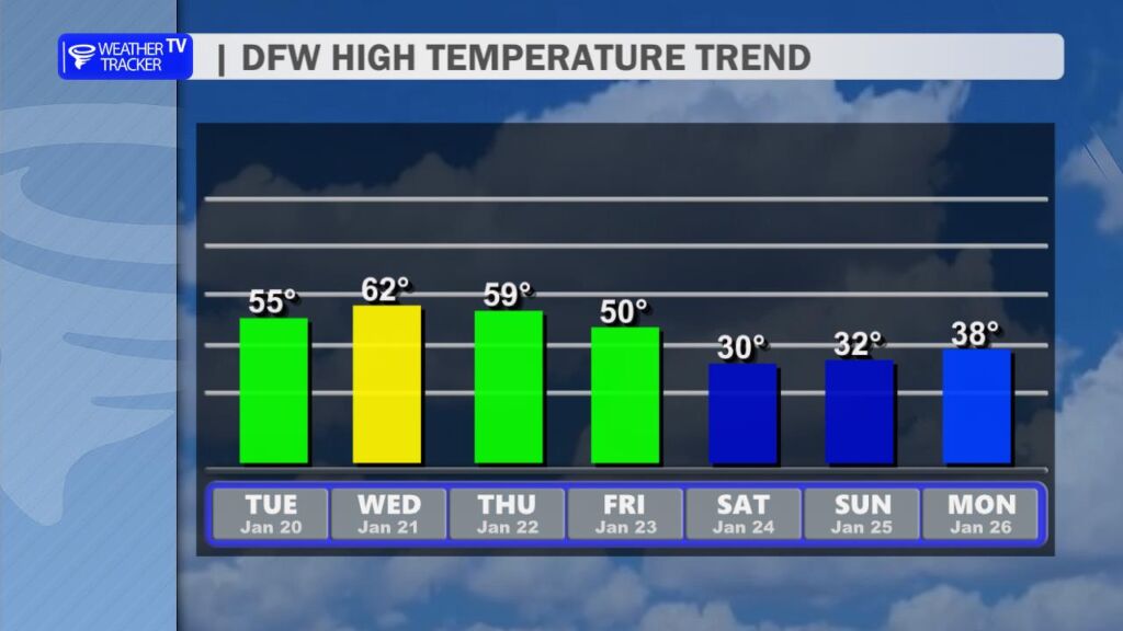
The big weather story this week is shaping up for Friday through the weekend, when the strongest Arctic cold front of the season so far barrels into North Texas. This isn’t your average cool-down – it’s a true Arctic intrusion combined with an upper-level storm system that will bring the potential for significant wintry precipitation.

The front is expected to push through early Friday, sending temperatures tumbling throughout the day. What starts as rain (or perhaps a cold rain) in many areas will transition to a wintry mix as colder air floods in from the north. Model data continues to highlight freezing rain as the predominant type in much of North Texas, along with possible sleet and even some snow accumulations, especially north and west of the metroplex.

This setup has all the ingredients for a potentially crippling winter storm: prolonged subfreezing temperatures (possibly 48+ hours below 32°F from late Friday into Sunday), ice accretion on roads, trees, and power lines, hazardous travel, and isolated power outages. While exact details on ice accumulation (e.g., tenths of an inch vs. more) and snowfall totals are still refining in the models this far out, confidence is increasing for impactful winter weather across North and Central Texas. The heaviest threats look to focus Friday night through Saturday, with lingering effects into Sunday morning.
It’s still early, and forecasts can shift, but this is the kind of event worth preparing for now:
- Stock up on essentials (food, water, medications, batteries).
- Ensure pipes, plants, and pets are protected from freezes.
- Have blankets, flashlights, and a backup heat source ready in case of outages.
- Monitor updates closely as we get closer to Friday.
Stay safe out there, and I’ll keep tracking this evolving story – updates coming as new data rolls in. -William