
From the National Hurricane Center:
For the North Atlantic Caribbean Sea and the Gulf of America:Tropical cyclone formation is not expected during the next 7 days.Forecaster Hagen
From the National Hurricane Center:
For the North Atlantic Caribbean Sea and the Gulf of America:Tropical cyclone formation is not expected during the next 7 days.Forecaster Hagen
North Texas Weather Alert: Big Changes Coming Today
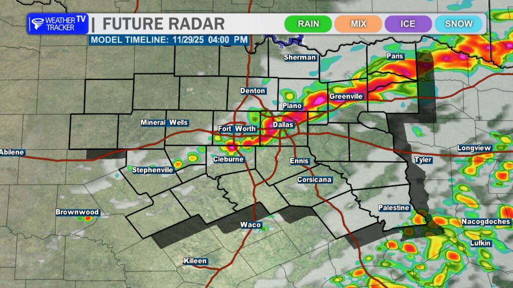
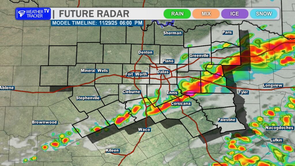
Buckle up, North Texas – a Blue Norther cold front is barreling into the Southern Plains and will push through North Texas late this afternoon and evening (Saturday, November 29, 2025). What starts as a mild, breezy day will flip dramatically once this cold front passes through.
This afternoon (before the front):
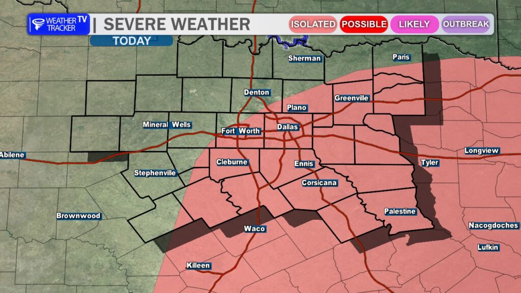
While most of the storms should stay sub-severe, an isolated severe thunderstorm cannot be ruled out. The primary threats from any stronger cell would be:
The bigger story, though, is what happens behind the front.
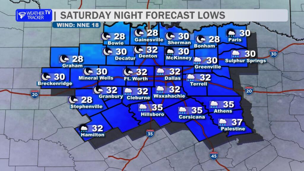
Tonight through Sunday morning:
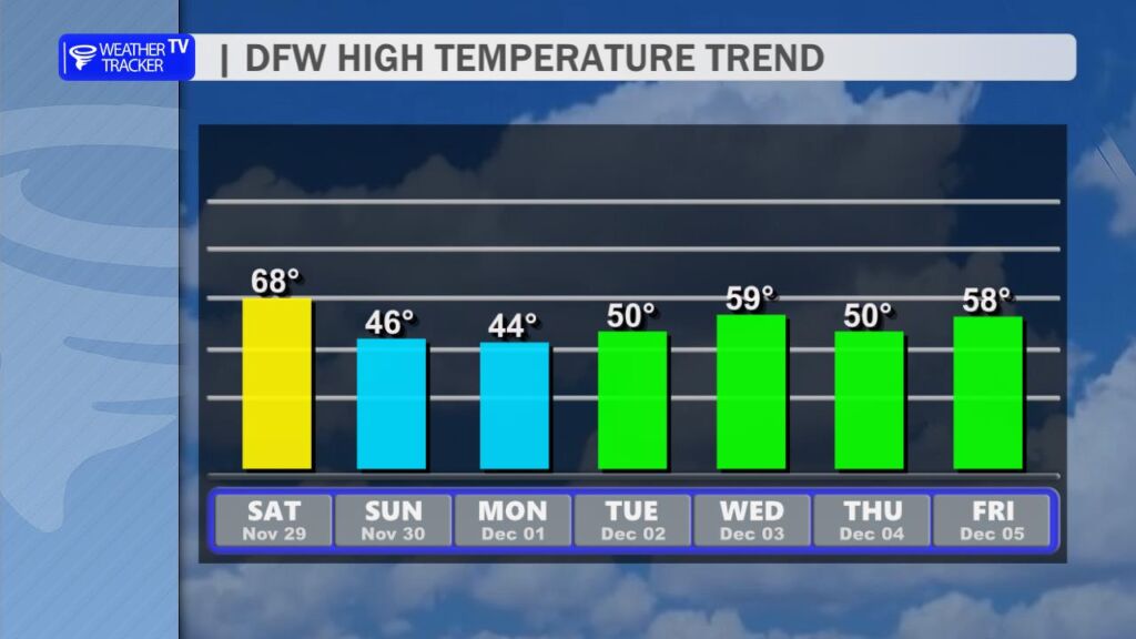
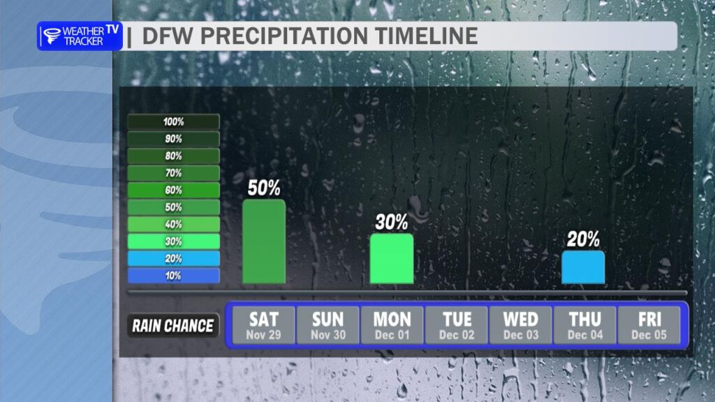
Looking forward:
Monday update:
Another quick-moving system brings a chance of light rain or drizzle Monday afternoon/evening. Right now, temperatures look marginal but should stay warm enough for plain rain across most of the area. The only exception may be far northeast counties near the Red River (Lamar, Fannin, Delta) where a few sleet pellets could briefly mix in. No travel impacts or accumulations are expected at this time.
Bottom line: Enjoy the mild air while it lasts this morning and early afternoon, because by tonight we’re flipping the switch to full-on winter mode for the next several days. Time to pull out the heavy coats, and bring in the sensitive plants.
Stay weather-aware and we’ll keep you updated if anything changes with the severe or wintry potential.
Here is a look at Actual Lows from around North Texas this morning.

Actual Lows from around the Dallas – Fort Worth Metroplex this morning.

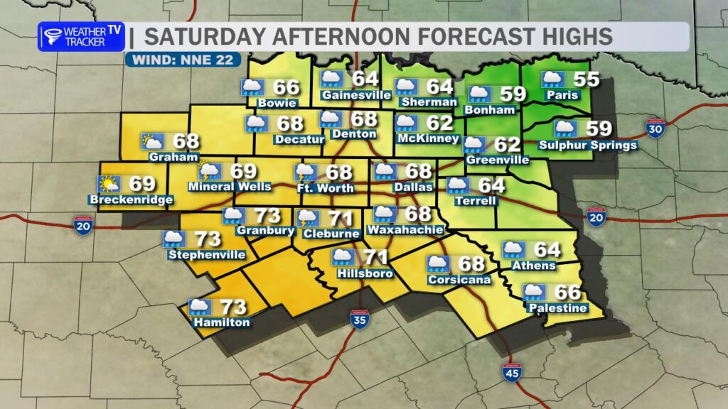
Here’s a look at our Saturday planner for the DFW Metroplex.


DFW TODAY…Cloudy with a chance of showers with a slight chance of thunderstorms this morning, then partly sunny with showers likely with a chance of thunderstorms this afternoon. Highs in the mid 60s. South winds 10 to 15 mph. Chance of rain 70 percent. -William


Here’s a look at our Saturday morning commute in the DFW Metroplex.


Here’s a look at MesoScan Radar and Live Temperatures across North Texas.
DFW TODAY Cloudy with a chance of showers with a slight chance of T-Storms this morning, then partly sunny with showers likely with a chance of T-Storms this afternoon. Highs in the mid 60s. South winds 10 to 15 mph. Chance of rain 70 percent.


From William Cole: A strong T-Storm will impact portions of northwestern Hunt and southeastern Collin Counties through MIDNIGHT
At 1123 PM , Live Radar was tracking a strong T-Storm near Farmersville, or 8 miles northeast of Wylie, moving northeast at 40 mph.
Winds In Excess Of 30 Mph And Penny Size Hail. Gusty Winds Could Knock Down Tree Limbs And Blow Around Unsecured Objects. Minor Damage To Outdoor Objects Is Possible.
Stay with William Cole and Weather Tracker TV Dallas – Fort Worth for continuing coverage, online, on our app and on TV. Let’s stay safe together.

From William Cole: A strong T-Storm will impact portions of east central Tarrant and northwestern Dallas Counties through 1030 PM
At 957 PM , Live Radar was tracking a strong T-Storm near Pantego, or near Forest Hill, moving northeast at 40 mph.
Winds In Excess Of 40 Mph And Nickel Size Hail. Gusty Winds Could Knock Down Tree Limbs And Blow Around Unsecured Objects. Minor Damage To Outdoor Objects Is Possible.
Stay with William Cole and Weather Tracker TV Dallas – Fort Worth for continuing coverage, online, on our app and on TV. Let’s stay safe together.
From William Cole: A strong T-Storm will impact portions of southern Tarrant County through 1000 PM
At 930 PM , Live Radar was tracking a strong T-Storm near Benbrook, moving east at 40 mph.
Winds In Excess Of 40 Mph And Nickel Size Hail. Gusty Winds Could Knock Down Tree Limbs And Blow Around Unsecured Objects. Minor Damage To Outdoor Objects Is Possible.
Stay with William Cole and Weather Tracker TV Dallas – Fort Worth for continuing coverage, online, on our app and on TV. Let’s stay safe together.