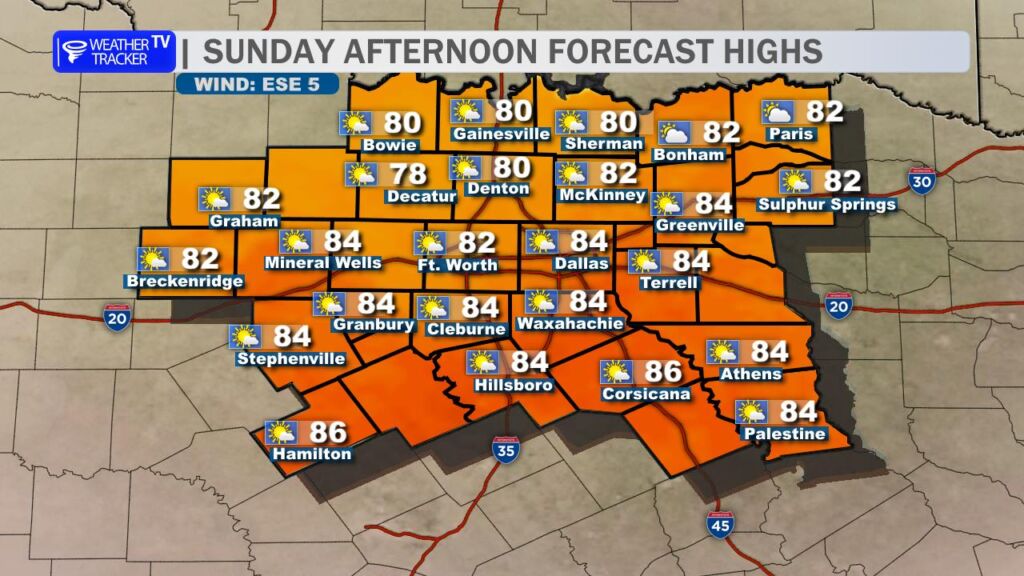
Today’s Forecast (Sunday, November 16)
Expect another warm afternoon across North Texas, though we’ll dial back the intensity from yesterday’s record-breaking heat.
- DFW Record Recap: Yesterday (Saturday, Nov 15), DFW Airport soared to 89°, shattering the previous daily record of 87° set way back in 1955. That’s a 70-year-old record now in the books!
- Today’s Highs: A weak surface boundary slipping through the region this morning will ease winds and shave a few degrees off the mercury. Look for afternoon highs in the low to mid-80s (82–85°F) across the Metroplex, with upper 70s to low 80s along and north of I-20.
- Winds: Lighter and more variable compared to yesterday’s gusty southwesterly flow. Expect 5–12 mph with occasional gusts to 15 mph, shifting from southwest to northwest behind the boundary.
- Sky Cover: Mostly sunny to partly cloudy. A few fair-weather cumulus may bubble up this afternoon, but no rain is expected.
Short-Term Outlook
Monday (November 17)
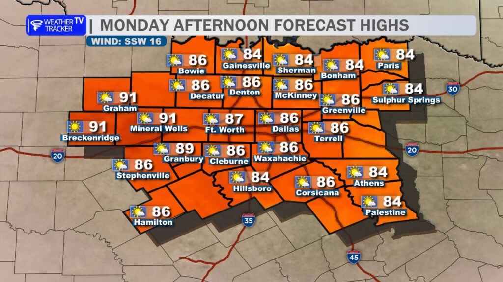
The warm-up resumes! High pressure rebuilds, pushing temperatures back into the mid to upper 80s (85–88°F) under mostly sunny skies. Winds return from the south at 10–15 mph. It’ll feel more like early October than mid-November.
Tuesday (November 18)
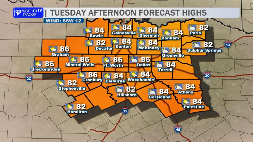
Continued warm with highs in the mid-80s. Increasing clouds late as our next system approaches from the west. Overnight lows stay mild in the mid-60s.
Main Weather Maker: Wednesday–Thursday (November 19–20)
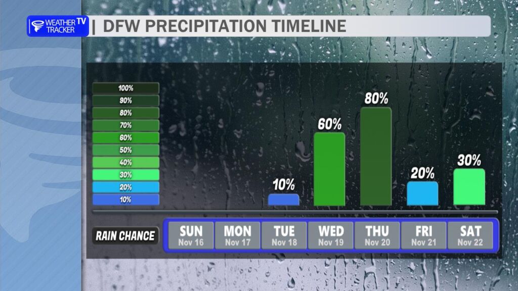
A potent upper-level trough and associated surface low will swing across the Southern Plains, bringing the first widespread rain chance in weeks. Multiple waves of showers and thunderstorms are likely, with the highest coverage Wednesday night into Thursday morning.
Key Impacts:
- Heavy Rainfall & Flooding Risk
- Areal average rainfall: 2–3 inches
- Localized higher amounts: up to 4 inches possible, especially along/east of I-35 where training storms may develop
- Flash Flood Concern: Urban areas (Dallas, Fort Worth, Arlington) and low-lying spots will be most vulnerable. Creeks and streams may rise quickly.
- Severe Weather Potential (Low-End)
- Primary Threats: Large hail (up to quarter-size) and damaging wind gusts (50–60 mph)
- Tornado Risk: Low, but not zero – any discrete storms ahead of the main line could rotate
- Greatest window: Wednesday afternoon/evening across Central TX, shifting east into North TX Wednesday night
- Timing Breakdown
- Wednesday AM: Scattered showers possible, mainly west of I-35
- Wednesday PM–Night: Main line of storms pushes in from the west; heaviest rain likely 6 PM Wednesday – 6 AM Thursday
- Thursday: Lingering showers taper off by afternoon; much cooler with highs only in the 60s
Beyond Thursday
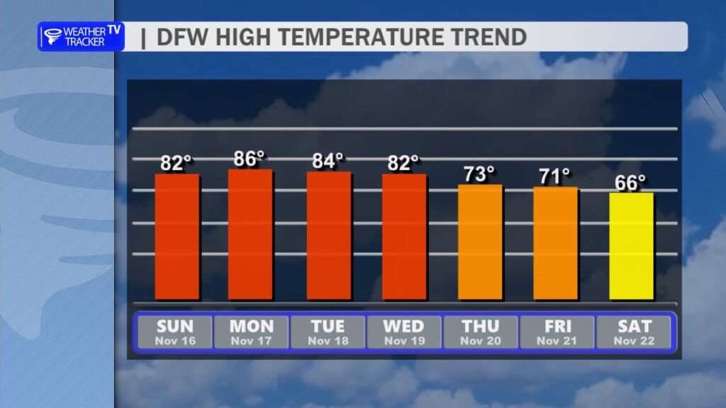
- Friday–Saturday: Dry and cooler. Highs in the 60s, lows in the 40s.
- Long-Range: Models hint at another system around Thanksgiving week, but confidence is low.
Bottom Line: Enjoy the warmth today and tomorrow, but prep for a soggy midweek. Secure loose outdoor items, clear gutters, and avoid flood-prone roads Wednesday night into Thursday. Stay weather-aware!
You must be logged in to post a comment.