The Week Ahead

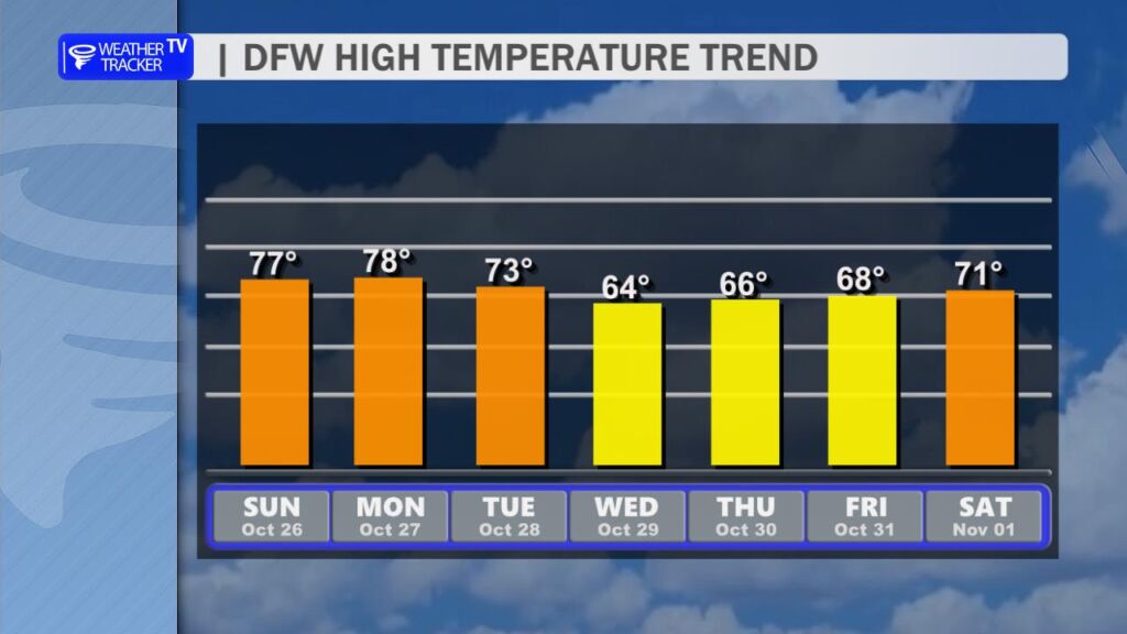
After a wet and stormy weekend across North Texas, we start the work week dry on Monday. Our next cold front arrives Tuesday morning, bringing brisk north winds and the chance for scattered showers or thunderstorms as it passes through – about a 30% probability in the DFW Metroplex. Highs will cool into the 60s behind the front, then rebound to the 70s by the upcoming weekend under mostly sunny skies.

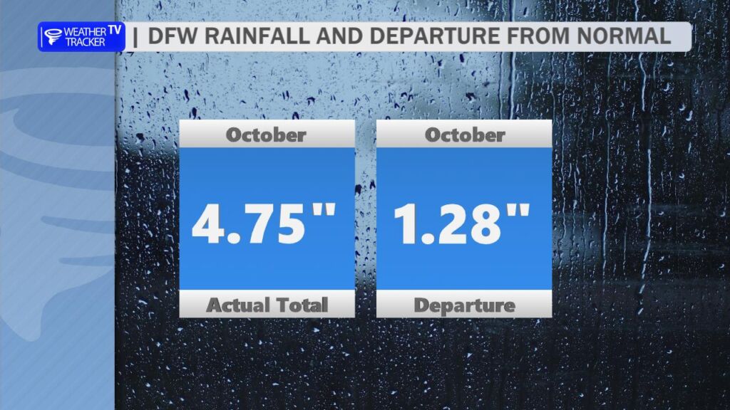
This past weekend delivered much-needed rainfall to the region. October is typically North Texas’ second-wettest month. Through last Thursday, DFW had officially recorded just 0.24″ for the month – well below normal. Thanks to the weekend storms, we added roughly 4.50″, putting us 1.28″ above normal for October so far.

7:34 AM | Dense Fog Advisory until 10:00 AM Sunday

Texas Weather Tracker TV Alert

From William Cole: A Dense Fog Advisory has been expanded in the Weather Tracker TV DFW coverage area from now until 10:00 AM Sunday for Bosque, Cooke, Erath, Grayson, Hamilton, Hood, Jack, Kaufman, Montague, Palo Pinto, Parker, Somervell, Wise & Young Counties in North Texas.

Patches of visibility one quarter mile or less in dense fog.

Stay with William Cole and Weather Tracker TV Dallas – Fort Worth for continuing coverage, online, on our app and on TV. Let’s stay safe together.

Your Support Helps

5:16 AM | Dense Fog Advisory until 10:00 AM Sunday

Texas Weather Tracker TV Alert

From William Cole: A Dense Fog Advisory has been issued in the Weather Tracker TV DFW coverage area from 5:16 AM Sunday until 10:00 AM Sunday for Collin, Dallas, Denton, Ellis, Hill, Johnson, Navarro, Rockwall & Tarrant Counties in North Texas.

Visibility one quarter mile or less in dense fog.

Stay with William Cole and Weather Tracker TV Dallas – Fort Worth for continuing coverage, online, on our app and on TV. Let’s stay safe together.

Your Support Helps

Overnight Update

Texas Weather Tracker TV Alert

Here’s a look at MesoScan Radar and Live Temperatures across North Texas.

DFW TONIGHT Mostly cloudy. A chance of showers and T-Storms this evening, then a slight chance of showers and T-Storms after midnight. Patchy fog after midnight. Lows around 60. South winds around 5 mph, becoming west after midnight. Chance of rain 50 percent.

Texas Weather Tracker TV Alert

NOW UPDATE | Saturday 6:29 PM Anderson County

Texas Weather Tracker TV Alert

From William Cole: A strong T-Storm will impact portions of central Anderson County through 700 PM

At 629 PM , Live Radar was tracking a strong T-Storm near Palestine, moving east at 45 mph.

Wind Gusts Up To 50 Mph. Gusty Winds Could Knock Down Tree Limbs And Blow Around Unsecured Objects.

Stay with William Cole and Weather Tracker TV Dallas – Fort Worth for continuing coverage, online, on our app and on TV. Let’s stay safe together.

Your Support Helps