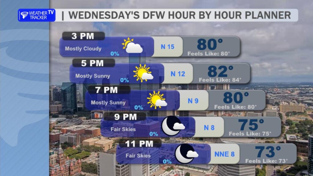
Here’s a look at our Wednesday evening commute in the DFW Metroplex.

Here’s a look at our Wednesday evening commute in the DFW Metroplex.
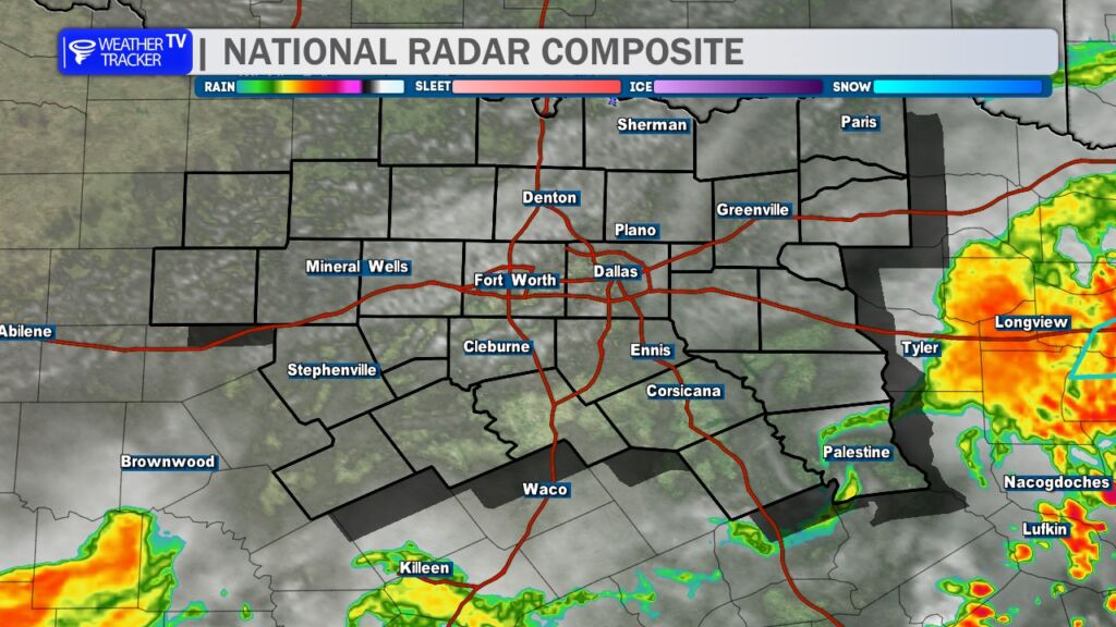
1PM: The morning rain and thunderstorm activity is now ending across North Texas with clearing skies. Enjoy Fall like temperatures this afternoon.

Here’s a look at Live Temperatures across North Texas, MesoScan Radar and the Updated Forecast Map.
DFW THIS AFTERNOON Partly sunny. Not as warm with highs in the lower 80s. Northwest winds 5 to 10 mph. -William


From the National Hurricane Center:
For the North Atlantic Caribbean Sea and the Gulf of America:Active Systems:The National Hurricane Center is issuing advisories on HurricaneGabrielle, located over the central subtropical Atlantic.Central and Western Tropical Atlantic (AL93):Shower and T-Storm activity associated with an elongated areaof low pressure located several hundred miles east of the LeewardIslands continues to show signs of organization. Environmentalconditions are forecast to be favorable for further development, anda tropical depression is likely to form later today or Thursdaywhile the system moves west-northwestward to northwestward into thewestern tropical Atlantic, well north of the Leeward Islands.Additional information on this system, including gale warnings, canbe found in High Seas Forecasts issued by the National WeatherService.* Formation chance through 48 hours high 90 percent.* Formation chance through 7 days high 90 percent.Eastern Caribbean Sea (AL94):A tropical wave over the northeastern Caribbean Sea is producingdisorganized showers and T-Storms. This wave is expected tomove west-northwestward at 15 to 20 mph, spreading heavy rainfalland gusty winds into Puerto Rico and the Virgin Islands today, andacross the Dominican Republic beginning tonight. The system is thenexpected to slow down and turn northwestward when it reaches thesouthwestern Atlantic late this week. Environmental conditions areforecast to be more conducive for development in a few days, and atropical depression is likely to form when the disturbance is in thevicinity of the Bahamas. Interests in the Virgin Islands, PuertoRico, the Dominican Republic, the Turks and Caicos Islands, and theBahamas should monitor the progress of this system. An Air ForceHurricane Hunter Aircraft is scheduled to perform a system surveythis afternoon to gather data from the surrounding environment, ifnecessary.* Formation chance through 48 hours low 30 percent.* Formation chance through 7 days high 80 percent.High Seas Forecasts issued by Weather Tracker TVcan be found under AWIPS header NFDHSFAT1, WMO header FZNT01KWBC, and online at ocean.weather.gov/shtml/NFDHSFAT1.phpForecaster Kelly

From William Cole: A strong T-Storm will impact portions of east central Hunt, Hopkins, north central Rains and southwestern Delta Counties through 945 AM
At 910 AM , Live Radar was tracking a strong T-Storm near Cumby, or 9 miles south of Commerce, moving east at 40 mph.
Winds In Excess Of 40 Mph And Half Inch Hail. Gusty Winds Could Knock Down Tree Limbs And Blow Around Unsecured Objects. Minor Damage To Outdoor Objects Is Possible.
Stay with William Cole and Weather Tracker TV Dallas – Fort Worth for continuing coverage, online, on our app and on TV. Let’s stay safe together.

Here is a look at Actual Lows from around North Texas this morning.

Actual Lows from around the Dallas – Fort Worth Metroplex this morning.

Here’s a look at our Wednesday planner for the DFW Metroplex.

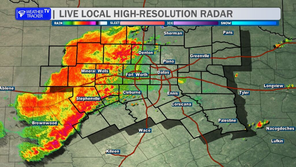
7:15 AM Update for the DFW Metroplex: It’s been relatively quiet in the DFW Metroplex this morning, but that will change over the next hour as a complex of rain and storms quickly moves in from the west. Expect heavy rainfall, frequent lightning, and wind gusts up to 50 MPH, which will impact the morning commute. Watch for ponding on roadways and potential localized street flooding. Fortunately, the storm activity is expected to remain below severe levels.

DFW TODAY…Mostly cloudy with a chance of showers and thunderstorms this morning, then partly sunny with a slight chance of showers this afternoon. Not as warm with highs in the lower 80s. Northwest winds 5 to 10 mph. Chance of rain 50 percent. -William


Here’s a look at our Wednesday morning commute in the DFW Metroplex.
