NOW UPDATE | Sunday 9:22 PM Hamilton County

Texas Weather Tracker TV Alert

From William Cole: A strong T-Storm will impact portions of south central Hamilton and northwestern Coryell Counties through 1000 PM

At 922 PM , Live Radar was tracking a strong T-Storm 7 miles south of Hamilton, moving southeast at 25 mph.

Winds In Excess Of 40 Mph And Nickel Size Hail. Gusty Winds Could Knock Down Tree Limbs And Blow Around Unsecured Objects. Minor Damage To Outdoor Objects Is Possible.

Stay with William Cole and Weather Tracker TV Dallas – Fort Worth for continuing coverage, online, on our app and on TV. Let’s stay safe together.
Your Support Helps

NOW UPDATE | Sunday 8:52 PM Erath County

Texas Weather Tracker TV Alert

From William Cole: A strong T-Storm will impact portions of central Erath County through 930 PM

At 852 PM , Live Radar was tracking a strong T-Storm over Huckabay, or 11 miles northwest of Stephenville, moving southeast at 15 mph.

Winds In Excess Of 40 Mph And Nickel Size Hail. Gusty Winds Could Knock Down Tree Limbs And Blow Around Unsecured Objects. Minor Damage To Outdoor Objects Is Possible.

Stay with William Cole and Weather Tracker TV Dallas – Fort Worth for continuing coverage, online, on our app and on TV. Let’s stay safe together.

Your Support Helps

Severe Weather Update 7:59 PM Erath & Palo Pinto Counties

Texas Weather Tracker TV Alert

From William Cole: A T-Storm Warning continues for for Erath & Palo Pinto Counties in North Texas until 8:45 PM.

At 759 PM , a severe T-Storm was located over Gordon, or 18 miles east of Ranger, moving southeast at 20 mph.

Primary Threats: 60 Mph Wind Gusts And Quarter Size Hail.

Stay with William Cole and Weather Tracker TV Dallas – Fort Worth for continuing coverage, online, on our app and on TV. Let’s stay safe together.

Your Support Helps

7:42 PM | T-Storm Warning Erath & Palo Pinto Counties until 8:45 PM Sunday

Texas Weather Tracker TV Alert

From William Cole: A T-Storm Warning has been issued in the Weather Tracker TV DFW coverage area for Erath & Palo Pinto Counties in North Texas until 8:45 PM.

At 742 PM , a severe T-Storm was located near Gordon, or 16 miles northeast of Ranger, moving southeast at 20 mph.

Hometowns Impacted: Gordon Around 745 Pm . Morgan Mill Around 830 Pm .

Primary Threats: 60 Mph Wind Gusts And Half Dollar Size Hail.

Stay with William Cole and Weather Tracker TV Dallas – Fort Worth for continuing coverage, online, on our app and on TV. Let’s stay safe together.

Your Support Helps

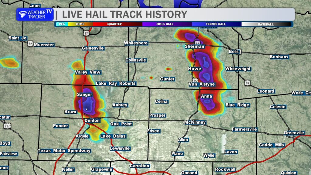
Two Large Hail Swaths this Evening

Large hail pummeled parts of North Texas this evening. Radar hail track history showed long swaths of purple and blue, indicating golf ball-sized hail across Grayson, northern Collin, and northern Denton counties.

Storm Timeline

  • Setup: Morning storms in Oklahoma left a boundary that triggered new thunderstorms by mid-afternoon. A Severe Thunderstorm Watch (4 PM) covered Grayson, northern Collin, northern Denton, and 12+ other counties, flagging hail and strong winds as primary threats.
  • Peak Impact (5-6:30 PM): Two supercells—one near Sanger/Luebbering (northern Denton) and another around Sherman (Grayson)—tracked southeast at 15-25 mph, hitting northern Collin (near Anna/Melissa) hard. Radar showed hail cores up to 2 inches (hen egg-sized), with ground reports confirming quarter- to golf ball-sized stones.
  • Fizzle Out: Storms weakened by 7:45 PM as they moved into eastern Collin and Hunt counties. No tornadoes reported, but some gusts reached 60-70 mph.

Hail Breakdown by County

From NWS warnings, radar estimates, and spotter reports:

CountyHail Size (Reported)Key Locations Affected
Grayson1-1.75 inchesSherman, Denison
Northern Collin1-1.5 inchesAnna, Melissa
Northern Denton1-1.75 inchesSanger, Luebbering

NOW UPDATE | Sunday 7:37 PM Erath & Hamilton Counties

Texas Weather Tracker TV Alert

From William Cole: A strong T-Storm will impact portions of northwestern Hamilton, southwestern Erath and southeastern Comanche Counties through 830 PM

At 737 PM , Live Radar was tracking a strong T-Storm 8 miles south of Dublin, moving southeast at 20 mph.

Winds In Excess Of 40 Mph And Nickel Size Hail. Gusty Winds Could Knock Down Tree Limbs And Blow Around Unsecured Objects. Minor Damage To Outdoor Objects Is Possible.

Stay with William Cole and Weather Tracker TV Dallas – Fort Worth for continuing coverage, online, on our app and on TV. Let’s stay safe together.

Your Support Helps

NOW UPDATE | Sunday 7:36 PM Erath & Palo Pinto Counties

Texas Weather Tracker TV Alert

From William Cole: A strong T-Storm will impact portions of northwestern Erath, northeastern Eastland and southwestern Palo Pinto Counties through 815 PM

At 735 PM , Live Radar was tracking a strong T-Storm near Gordon, or 16 miles northeast of Ranger, moving southeast at 25 mph.

Winds In Excess Of 40 Mph And Nickel Size Hail. Gusty Winds Could Knock Down Tree Limbs And Blow Around Unsecured Objects. Minor Damage To Outdoor Objects Is Possible.

Stay with William Cole and Weather Tracker TV Dallas – Fort Worth for continuing coverage, online, on our app and on TV. Let’s stay safe together.

Your Support Helps

Severe Weather Update 7:02 PM Dallas, Denton & Tarrant Counties

Texas Weather Tracker TV Alert

From William Cole: A T-Storm Warning continues for for Dallas, Denton & Tarrant Counties in North Texas until 7:45 PM.

At 702 PM , a severe T-Storm was located over Highland Village, moving south at 20 mph.

Primary Threats: 60 Mph Wind Gusts And Penny Size Hail.

Stay with William Cole and Weather Tracker TV Dallas – Fort Worth for continuing coverage, online, on our app and on TV. Let’s stay safe together.

Your Support Helps