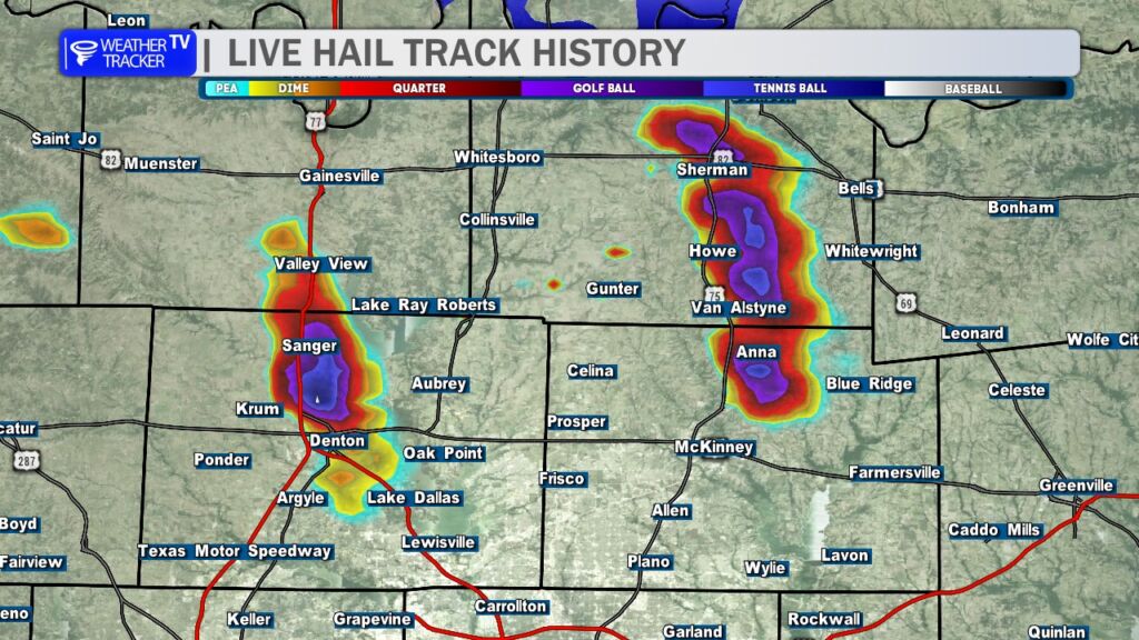
Large hail pummeled parts of North Texas this evening. Radar hail track history showed long swaths of purple and blue, indicating golf ball-sized hail across Grayson, northern Collin, and northern Denton counties.
Storm Timeline
- Setup: Morning storms in Oklahoma left a boundary that triggered new thunderstorms by mid-afternoon. A Severe Thunderstorm Watch (4 PM) covered Grayson, northern Collin, northern Denton, and 12+ other counties, flagging hail and strong winds as primary threats.
- Peak Impact (5-6:30 PM): Two supercells—one near Sanger/Luebbering (northern Denton) and another around Sherman (Grayson)—tracked southeast at 15-25 mph, hitting northern Collin (near Anna/Melissa) hard. Radar showed hail cores up to 2 inches (hen egg-sized), with ground reports confirming quarter- to golf ball-sized stones.
- Fizzle Out: Storms weakened by 7:45 PM as they moved into eastern Collin and Hunt counties. No tornadoes reported, but some gusts reached 60-70 mph.
Hail Breakdown by County
From NWS warnings, radar estimates, and spotter reports:
| County | Hail Size (Reported) | Key Locations Affected |
|---|---|---|
| Grayson | 1-1.75 inches | Sherman, Denison |
| Northern Collin | 1-1.5 inches | Anna, Melissa |
| Northern Denton | 1-1.75 inches | Sanger, Luebbering |
You must be logged in to post a comment.